Did Typhoon Wipha Make Its Second Landfall in Guangdong?
Click to start listening
Synopsis
Typhoon Wipha strikes Guangdong twice, bringing intense winds and heavy rain. As authorities respond with emergency measures, the storm raises concerns for coastal areas. What does this mean for the region's safety and future weather events? Find out more about Typhoon Wipha's impact.
Key Takeaways
- Typhoon Wipha made a second landfall in Guangdong Province.
- Wind speeds reached up to 33 meters per second during its first landfall.
- Emergency responses have been escalated across southern China.
- Heavy rains and gales are expected until July 22.
- Guangdong has deployed rescue resources to prepare for potential casualties.
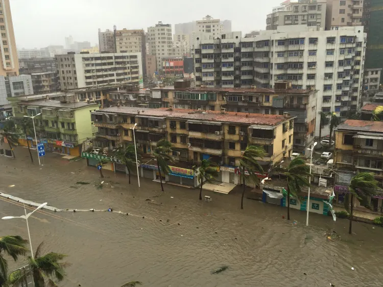
Guangzhou, July 20 (NationPress) - Typhoon Wipha, marking the sixth typhoon of this year, has made its second landfall near Hailing Island in Yangjiang, located in southern China's Guangdong Province, on Sunday as a powerful tropical storm. According to the provincial meteorological observatory, the storm recorded a maximum wind speed of 25 meters per second near its core.
Wipha is predicted to travel west-southwest at approximately 20 kilometers per hour, gradually diminishing in strength.
Earlier on Sunday, around 5:50 PM, Wipha initially made landfall near Haiyan Town in Jiangmen City, Guangdong, boasting a maximum wind speed of 33 meters per second.
As Wipha approached the South China Sea, high alert was declared in southern China's Hainan and Guangdong provinces, accompanied by intense gales and torrential rains.
Hainan activated a Level IV emergency response, while Guangdong escalated its response from Level IV to Level II at 11 AM.
The Hainan Meteorological Service noted that Typhoon Wipha intensified from a tropical storm to a strong tropical storm early Saturday. By 8 AM, its center was located in the northeastern region of the South China Sea, approximately 930 kilometers east of Wenchang City in Hainan.
Yesterday, it was estimated that Wipha was advancing northwest at a speed of about 20 kilometers per hour, strengthening as it neared the coastal regions from Shenzhen in Guangdong to Wenchang in Hainan, with a likelihood of making landfall between Sunday afternoon and evening, as reported by Xinhua news agency.
Due to the storm's effects, from Saturday to July 22, vast sea regions and land areas in Hainan are expected to experience heavy rainfall and strong winds. Furthermore, the Qiongzhou Strait between Guangdong and Hainan may face extended shipping suspensions from Sunday until July 22.
Guangdong has also prepared specialized rescue vessels, helicopters, high-powered tugboats, and cleanup vessels on standby.
China's emergency response system for typhoons operates on a four-tier scale, with Level I being the most critical.
Point of View
I emphasize the importance of reporting on Typhoon Wipha not just as a weather event but as a critical issue affecting the lives and safety of countless individuals in southern China. The nation's preparedness and responsiveness to such natural disasters showcase its commitment to protecting its citizens.
NationPress
20/07/2025
Frequently Asked Questions
What is the current status of Typhoon Wipha?
Typhoon Wipha has made its second landfall in Guangdong, with maximum wind speeds of 25 meters per second and is expected to weaken moving forward.
How are authorities responding to Typhoon Wipha?
Emergency responses have been activated in Hainan and Guangdong, with measures including rescue vessels and helicopters on standby.
What areas are expected to be affected by the storm?
Coastal regions from Shenzhen in Guangdong to Wenchang in Hainan are predicted to be impacted with rainstorms and strong winds.