Is a Cyclonic System Set to Impact the Odisha-Andhra Coast by October 3?

Synopsis
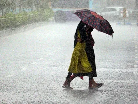
A significant cyclonic system is brewing in the Bay of Bengal, raising concerns for Odisha and Andhra Pradesh. With heavy rainfall and thunderstorms expected, residents are urged to stay alert. As the system intensifies, the potential impact on local communities could be severe. Stay informed with the latest updates.
Key Takeaways
Cyclonic system over Odisha and Andhra Pradesh.
Heavy rainfall forecasted with potential for severe thunderstorms.
Orange Warning issued for extreme rain in specific districts.
Residents urged to prepare for possible impacts.
Historical context highlights the region's cyclone vulnerability.
Bhubaneswar, Sep 30 (NationPress) A cyclonic system is currently situated over Odisha and the nearby north Andhra Pradesh coast in the west-central Bay of Bengal, according to Sanjeev Dwivedi, Scientist-D at IMD Bhubaneswar, on Tuesday. As a result of this system, an additional cyclonic circulation is anticipated to form over the north Andaman Sea on September 30.
This occurrence may lead to the establishment of a low-pressure area over the central Bay of Bengal on October 1.
In a statement to IANS, Sanjeev Dwivedi indicated, “The system is projected to advance west-northwest and intensify into a depression over the west-central and adjacent northwest Bay of Bengal around October 2. It is expected to make landfall on the south Odisha-north Andhra Pradesh coast by the morning of October 3. Rainfall activity is likely to persist over the next four days.”
For September 30, heavy rainfall (Yellow Alert) has been predicted at isolated locations in Ganjam, Gajapati, Rayagada, Kalahandi, and Kandhamal districts. Thunderstorms accompanied by lightning and wind speeds of 30-40 kmph are expected in coastal, adjoining, and northern districts, including Sundargarh, Jharsuguda, and Sambalpur.
The intensity of rainfall is forecasted to escalate in the upcoming days, with significant precipitation (Yellow Alert) likely in Ganjam, Gajapati, Rayagada, Koraput, Malkangiri, Nabarangpur, Kalahandi, and Kandhamal, with wind speeds reaching 40-50 kmph in at-risk districts.
An Orange Warning for extremely heavy rainfall (7-20 cm) has been issued for select areas in Gajapati, Rayagada, Koraput, Malkangiri, and Kandhamal. In addition, 12 districts—including Mayurbhanj, Keonjhar, Balasore, Nabarangpur, Kalahandi, Ganjam, Puri, Khurda, Nayagarh, and Cuttack—are expected to experience heavy rainfall (Yellow Alert).
Thunderstorms with lightning are predicted across most of Odisha, while coastal and alert districts may see wind speeds of up to 50 kmph.
Odisha has a history of being one of the most cyclone-prone states in India. In 1999, the state faced one of the most catastrophic cyclonic events in history known as the Super Cyclone, which struck with wind speeds nearing 300 kmph, wreaking havoc in 14 coastal districts, 28 towns, and significant cities such as Bhubaneswar and Cuttack. Almost 10,000 people lost their lives, and over 13 million were impacted.
Point of View
It's imperative that we recognize the ongoing threat posed by the cyclonic system over Odisha and Andhra Pradesh. Our commitment to providing accurate and timely updates ensures that communities can prepare effectively. The history of cyclones in this region underscores the need for vigilance and preparedness as we navigate this weather event.
NationPress
3 Jul 2026
Frequently Asked Questions
What areas are expected to be affected by the cyclonic system?
The cyclonic system is expected to impact regions in Odisha and north Andhra Pradesh, particularly coastal areas.
What kind of rainfall can we expect?
Heavy rainfall and thunderstorms are forecasted, with an Orange Warning for extreme rain in specific districts.
How fast are the winds expected to be?
Wind speeds could reach up to 50 kmph in affected districts.
Is there a history of severe cyclones in this region?
Yes, Odisha is known for its vulnerability to cyclones, with the Super Cyclone of 1999 being one of the deadliest.
What should residents do to prepare?
Residents are advised to stay informed, secure their homes, and follow local authorities' guidance.