How is Geospatial Technology Essential for Evidence-Based Governance in Arunachal Pradesh?
Click to start listening
Synopsis
In a recent address, Arunachal Pradesh's Governor, Lt. General K.T. Parnaik (Retd.), underscored the pivotal role of geospatial technology in fostering evidence-based governance. Discover how these technologies can transform planning, disaster management, and sustainable development in the region.
Key Takeaways
- Geospatial technology is essential for evidence-based governance.
- It enhances planning and resource allocation through accurate data.
- Supports disaster management with real-time monitoring capabilities.
- Boosts agricultural productivity by identifying optimal farming areas.
- Promotes sustainable tourism through precise mapping.
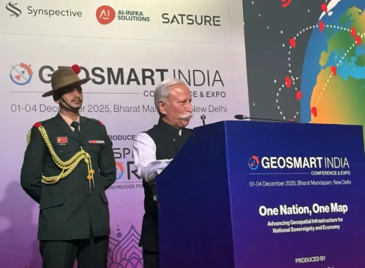
Itanagar, Dec 2 (NationPress) The Governor of Arunachal Pradesh, Lt. General K.T. Parnaik (Retd.), emphasized on Tuesday the critical role of geospatial technology—including GIS, GPS, drones, satellite imagery, and digital mapping—in fostering smart and evidence-based governance.
While addressing the GeoSmart India 2025 conclave at Bharat Mandapam in New Delhi, he stated that this technology enhances the development process by accurately mapping terrains, resources, and infrastructure gaps. This enables planners to identify optimal locations for roads, bridges, and public services, thereby minimizing guesswork and aligning with the actual needs of communities and the environment.
The four-day conference-cum-expo, centered around the theme ‘One Nation, One Map — Advancing Geospatial Infrastructure for National Sovereignty and Economy’, is organized by Geospatial Media and Communications.
While participating in the Northeast segment of the conclave, the Governor mentioned that geospatial tools make monitoring land use, forests, water resources, crop patterns, and project progress more transparent and efficient. This allows for timely interventions based on real-time data. He noted that these technologies support a scientific assessment of natural resources, climate trends, biodiversity, and socio-economic patterns, equipping policymakers with the data needed for informed decision-making.
Lt. General Parnaik (Retd.) highlighted that prior to launching major projects, geospatial analysis can assess feasibility, risks, and environmental sensitivities, which helps in minimizing disputes and over-expenditure.
He recommended the creation of a state-level geospatial policy, forming a central data repository, training government personnel in GIS, utilizing dashboards for public initiatives, integrating drone-based mapping, and enhancing inter-departmental collaboration. This would generate cohesive geospatial datasets that promote better decision-making.
The Governor asserted that geospatial technology will serve as a transformative catalyst for Arunachal Pradesh, facilitating wise planning and growth. These tools are crucial for disaster preparedness, enabling early detection of landslide-prone areas, flood pathways, and at-risk communities, thus expediting targeted responses. Additionally, geospatial monitoring will fortify environmental safeguards by overseeing forests, wildlife corridors, and river systems. It will also boost agriculture by pinpointing optimal regions for crops such as kiwi, orange, and apple, and support precision farming techniques.
Furthermore, it will enhance both urban and rural development through improved land records, drainage strategies, and asset management; aid in border management along remote areas; and promote sustainable tourism with accurate mapping of trekking routes, cultural landmarks, and eco-tourism zones.
Recently, the Governor reviewed the implementation of PM GatiShakti in Arunachal Pradesh, stating that while this platform is invaluable for monitoring welfare schemes and infrastructure projects, the state needs to advance further.
He stressed the importance of developing a state-specific AI application tailored to local needs and geographical realities. This would enable the government to create an integrated, user-friendly dashboard accessible to all departments, enhancing coordination, minimizing redundant efforts, and ensuring quicker decision-making, greater transparency, and more responsive governance for the residents of Arunachal Pradesh.
Point of View
Integrating such technologies will be crucial for sustainable development and effective resource management.
NationPress
02/12/2025
Frequently Asked Questions
What is geospatial technology?
Geospatial technology encompasses various tools like GIS, GPS, drones, and satellite imagery that collect, analyze, and manage spatial data.
Why is geospatial technology important for governance?
It enhances decision-making by providing accurate data on resources, infrastructure, and environmental factors, thus supporting evidence-based governance.
How can geospatial technology aid in disaster management?
It allows for early identification of high-risk areas, facilitating timely responses and effective resource allocation during disasters.
What are the applications of geospatial technology in agriculture?
Geospatial tools help identify suitable farming zones, monitor crop health, and implement precision farming techniques.
How does geospatial technology contribute to sustainable tourism?
It enables accurate mapping of trekking routes and cultural sites, promoting eco-tourism and protecting natural resources.