Is Work on Hyderabad's Old City Metro Rail Corridor Accelerating?
Click to start listening
Synopsis
The Metro Rail connectivity project for Hyderabad's Old City is progressing rapidly, with crucial land acquisition and demolition efforts reaching pivotal milestones. With innovative engineering solutions in play, the dream of a Metro Rail system for the Old City is closer to realization. Discover the ongoing challenges and advancements in this significant urban development.
Key Takeaways
- Metro Rail connectivity is advancing rapidly in Hyderabad's Old City.
- Innovative engineering has reduced the number of affected properties.
- Compensation of Rs 433 crore has been disbursed to property owners.
- Advanced technologies like DGPS and GPR are being employed for precision.
- Collaboration among agencies ensures smooth utility relocation.
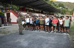
Hyderabad, Sep 7 (NationPress) The preparatory activities aimed at establishing Metro Rail connectivity to the Old City of Hyderabad are advancing significantly, as announced by Hyderabad Airport Metro Limited (HAML) Managing Director N.V.S. Reddy on Sunday.
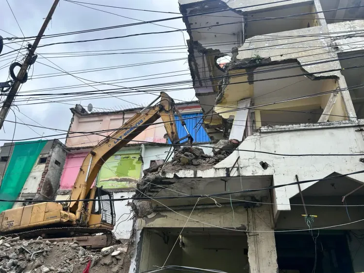
He indicated that the processes of land acquisition and the demolition of affected structures within the 7.5 km Old City Metro Corridor have reached a pivotal point, with nearly all required Right of Way (RoW) now secured.
Following directives from Chief Minister A. Revanth Reddy, the expansion efforts are being executed swiftly. The MD assured that every possible measure is being taken to fulfill the long-awaiting aspiration of Metro Rail connectivity for the residents of the Old City.
Initially, it was estimated that approximately 1,100 properties would be affected; however, through innovative engineering strategies, this number has been reduced to 886. More than 550 demolitions have been completed, with ongoing efforts to clear the remaining structures.
He disclosed that compensation totaling Rs 433 crore has already been distributed to property owners.
Despite facing challenges such as rainfall, festivals, and Muharram, the works have progressed without causing disruption to local residents. Complicated electrical cable removals presented obstacles, but these have been effectively managed, the MD noted.
Reddy stated that preparatory tasks for the construction of Metro pillars and stations are proceeding rapidly. Key focus areas include differential GPS (DGPS) surveys for precise mapping, identification and relocation of underground utilities, soil testing and geotechnical analysis, and safeguarding sensitive heritage structures along the route.
Unlike conventional surveys, DGPS provides high-accuracy digital mapping. Data gathered from DGPS has been combined with earlier drone surveys to expedite implementation. The corridor has been segmented, with control points established for precise positioning using high-accuracy GNSS (Global Navigation Satellite System) receivers. These satellite-based signals are crucial for survey and mapping endeavors, the MD explained.
Reddy highlighted the necessity of identifying and diverting underground obstacles at pillar sites. Due to the age of the roads, numerous water, sewage, stormwater, electricity, and telecom lines are present beneath the surface. According to the master plan, the road is being expanded to 100 feet, which requires the demolition of affected properties.
Agencies such as the Hyderabad Water Board, GHMC, TGSPDCL, and BSNL are collaborating to relocate utilities. Ground Penetrating Radar (GPR) surveys are being executed to detect underground structures and materials.
Geotechnical assessments are being conducted to evaluate soil strength and groundwater conditions to ensure that the Metro foundations are robust enough to support the load. These evaluations are essential prior to commencing construction.
The alignment traverses several sensitive structures, which have been identified, and adjustments have been made accordingly. Pillar locations are being marked based on this refined alignment, with milestone markers installed every 100 meters to guide construction, the MD concluded.
Point of View
I believe the ongoing Metro Rail project in Hyderabad's Old City exemplifies the city's commitment to modern infrastructure while balancing heritage preservation. The collaborative efforts of various agencies and the innovative solutions being implemented are commendable. This project holds promise for enhancing connectivity and urban development, fostering growth for the region.
NationPress
07/09/2025
Frequently Asked Questions
What is the current status of the Metro Rail project in Hyderabad's Old City?
The preparatory work for the Metro Rail connectivity to the Old City is progressing well, with land acquisition and demolition at critical stages.
How many properties are affected by the Metro Rail project?
Initially, around 1,100 properties were estimated to be affected, but innovative solutions have reduced this number to 886.
What measures are being taken to ensure minimal disruption during construction?
Despite challenges from weather and festivals, construction has proceeded without major inconveniences to local residents.
What kind of technologies are being utilized in the survey process?
Differential GPS (DGPS) and Ground Penetrating Radar (GPR) are being used for accurate mapping and detection of subsurface structures.
What is the expected outcome of this Metro Rail project?
The project aims to provide efficient Metro Rail connectivity, enhancing transportation options for the residents of Hyderabad's Old City.