India inland waterways cargo hits 218 MMT, beats Maritime Vision 2030 target
Synopsis
India's inland waterways carried 218 MMT of cargo in 2025–26 — beating the Maritime India Vision 2030 target of 200 MMT more than four years early, at a CAGR of 20.13% since 2014–15. With NW-2 expanding along the Brahmaputra and digital navigation tools rolling out across 22 waterways, India's river network is quietly becoming a serious logistics force multiplier.
Key Takeaways
India's inland waterways cargo reached 218 MMT in 2025–26 , up from 29 MMT in 2014–15 , at a CAGR of 20.13% .
The 200 MMT target under Maritime India Vision 2030 has been surpassed more than four years ahead of schedule.
National Waterway-2 (Dhubri–Sadiya, 891 km ) saw cargo rise from 0.90 MMT in FY25 to 1.29 MMT in FY26.
Water freight costs roughly one-third of road and half of rail transport per tonne, with lower carbon emissions.
Thalweg surveys covered 22 National Waterways as of September 2026 ; 32 of 111 national waterways are currently operational.
The Indo-Bangladesh Protocol route is also integrated into the national waterway monitoring framework.
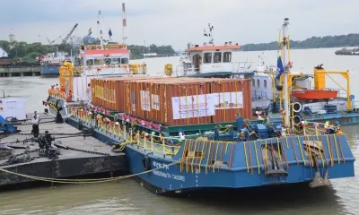
India's inland waterways have crossed a landmark milestone, with cargo movement rising from 29 million metric tonnes (MMT) in 2014–15 to 218 MMT in 2025–26 — a compound annual growth rate (CAGR) of 20.13% that has already surpassed the 200 MMT target set under Maritime India Vision 2030, according to an official factsheet released on Friday, 16 October 2026. The achievement, more than four years ahead of the deadline, marks a decisive shift from waterways potential to measurable performance.
National Waterway-2 Leads the Charge
National Waterway-2 (NW-2), connecting Dhubri to Sadiya along an 891-kilometre navigable stretch — the longest in the country — has emerged as a key growth corridor. Cargo on NW-2 climbed from 0.90 MMT in FY25 to 1.29 MMT in FY26, signalling rising commercial activity along the Brahmaputra river basin. New riverine lighthouses are being added along the waterway to enable round-the-clock vessel movement, according to the factsheet.
Why Inland Waterways Matter for the Economy
Moving a tonne of freight by water costs roughly one-third of road transport and approximately half of rail, while generating a fraction of carbon emissions. This cost and emissions advantage makes waterways a strategic tool for decarbonising freight logistics and relieving congestion on national highways, reserving road capacity for passengers and time-sensitive cargo. Officials noted that India's rivers are increasingly being positioned as a 'force multiplier' for the broader economy.
Digital and Infrastructure Upgrades Underway
Hydrographic surveys and fairway maintenance are being carried out to help vessels navigate shifting river conditions. Digital platforms now provide real-time information on depths, routes, vessel positions, and weather. Regular thalweg surveys covered 22 National Waterways as of September 2026, conducted weekly, fortnightly, or monthly depending on the specific waterway. The Indo-Bangladesh Protocol (IBP) route — an inland water transit network enabling cross-border cargo movement through designated river corridors — is also covered under this monitoring framework.
Scale of the National Waterways Network
India has 111 National Waterways, spanning a combined length of 20,187 km across 23 states and 4 Union Territories. Of these, 32 are currently operational. New projects along the Brahmaputra corridor are combining navigation safety, technological support, and tourism development, signalling a broader strategic vision beyond freight alone.
What Comes Next
With the 200 MMT threshold already breached, attention is likely to shift toward expanding the number of operational waterways beyond the current 32 and deepening infrastructure investment on high-potential corridors like NW-2. Sustained survey coverage and digital integration will be critical to maintaining safe navigability as cargo volumes continue to grow.
Point of View
But the more telling metric is how thin the operational base remains — just 32 of 111 declared National Waterways are active. The 20% CAGR reflects a low starting point as much as genuine momentum. NW-2's growth along the Brahmaputra is encouraging, yet the corridor still carries barely 1.29 MMT against a 218 MMT national aggregate, suggesting concentration risk and infrastructure gaps. The real challenge now is distributing growth across the remaining 79 non-operational waterways, which will require sustained capital commitment and state-level coordination — neither of which can be declared complete from a factsheet.
NationPress
16 Oct 2026
Frequently Asked Questions
How much cargo did India's inland waterways carry in 2025–26?
India's inland waterways carried 218 MMT of cargo in 2025–26, up from 29 MMT in 2014–15, representing a CAGR of 20.13%. This figure has already surpassed the 200 MMT target set under Maritime India Vision 2030.
What is Maritime India Vision 2030 and what was the waterways target?
Maritime India Vision 2030 is a long-term blueprint for developing India's maritime sector, including ports, shipping, and inland waterways. One of its key targets was moving 200 MMT of cargo via inland waterways by 2030 — a goal that has now been achieved ahead of schedule.
What is National Waterway-2 and why is it significant?
National Waterway-2 connects Dhubri to Sadiya along the Brahmaputra river in Assam over an 891-kilometre navigable stretch, making it the longest National Waterway in India. Cargo on NW-2 grew from 0.90 MMT in FY25 to 1.29 MMT in FY26, and new riverine lighthouses are being added to enable round-the-clock navigation.
Why is water freight considered cheaper and greener than road or rail?
Transporting one tonne of freight by water costs roughly one-third of road transport and about half of rail, while generating significantly lower carbon emissions. This makes inland waterways a cost-efficient and environmentally preferable option, reducing stress on national highways and rail networks.
How many National Waterways are currently operational in India?
Of India's 111 designated National Waterways spanning 20,187 km across 23 states and 4 Union Territories, 32 are currently operational. The government is investing in hydrographic surveys, digital navigation platforms, and new lighthouse infrastructure to expand capacity.