What Happened During the Recent Eruption of Indonesia's Mount Lewotobi Laki-laki?
Click to start listening
Synopsis
Discover the latest eruption of Mount Lewotobi Laki-laki, a powerful volcano in Indonesia, which has raised significant concerns for aviation and local communities. With its ash plume reaching 5 km and the highest alert issued, this event underscores Indonesia's ongoing volcanic activity and the risks involved.
Key Takeaways
- Mount Lewotobi Laki-laki has erupted, spewing ash 5 km high.
- A red level aviation alert has been issued, restricting flights.
- Communities are advised to avoid a 6 km radius from the crater.
- Residents should wear masks during ash fallout.
- This is part of Indonesia's ongoing volcanic activity.
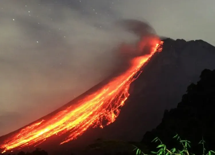
Jakarta, Oct 1 (NationPress) Mount Lewotobi Laki-laki volcano, situated in East Nusa Tenggara province of Indonesia, erupted once again on Wednesday, releasing an impressive ash plume that reached heights of up to 5 km. This significant event has triggered the highest level of aviation alert, as reported by the country's Volcanology and Geological Disaster Mitigation Center.
The volcano, found on Flores Island, produced thick gray clouds of ash that drifted towards the west and northwest of the crater.
A Volcano Observatory Notice for Aviation was issued, categorized at the red level—the most severe warning—which prohibits flights operating below 6,000 meters within the vicinity of the volcano, according to Xinhua News Agency. Airlines have been cautioned to prepare for possible disruptions due to volcanic ash.
Local authorities have advised communities living on the slopes of the volcano, alongside tourists and visitors, to refrain from activities within a 6-km radius of the crater. They also warned of the risk of potential lava flows along rivers that originate from the peak during periods of heavy rainfall.
Residents in areas impacted by ash fallout are encouraged to wear masks or cover their mouths and noses to mitigate respiratory issues.
Previously, Mount Lewotobi Laki-laki experienced two eruptions in August, with ash clouds rising as high as 18,000 meters, according to local officials.
The recent eruption was marked by rumbling noises and loud explosions reported by the volcano observation post, with seismographic data indicating a maximum amplitude of 47.3 mm and a duration of about 14 minutes and 5 seconds for the larger eruption.
At a height of 1,584 meters, Mount Lewotobi ranks among Indonesia's 127 active volcanoes. Indonesia, home to 270 million residents, frequently experiences seismic activity and has 120 active volcanoes, situated along the 'Ring of Fire'—a series of seismic fault lines encircling the Pacific Basin.
Located at the convergence of several major tectonic plates, including the Eurasian, Australian, and Pacific plates, Indonesia has endured some of the most catastrophic and powerful eruptions globally, such as the infamous Mount Tambora eruption in 1815, underscoring the country's susceptibility to volcanic dangers.
Point of View
I believe it is crucial to remain informed about such significant geological events. Mount Lewotobi Laki-laki's recent eruption not only highlights the ongoing volcanic activity in Indonesia but also serves as a reminder of the natural hazards that can affect communities and aviation. Our role is to ensure that accurate and timely information is disseminated to help keep the public safe.
NationPress
01/10/2025
Frequently Asked Questions
What is the height of Mount Lewotobi Laki-laki?
Mount Lewotobi Laki-laki stands at 1,584 meters.
How high did the ash plume reach during the recent eruption?
The ash plume reached heights of up to 5 km.
What precautions have been taken for aviation safety?
A red level alert has been issued, banning flights below 6,000 meters near the volcano.
What should residents do during ash fallout?
Residents are advised to wear masks or cover their mouths and noses to protect against respiratory hazards.
How many active volcanoes are there in Indonesia?
Indonesia has 127 active volcanoes.