Israel Unveils Controversial Buffer Zone Map in Southern Lebanon Amid Ongoing Military Operations
Synopsis
Israel's military has introduced a map revealing a proposed buffer zone in southern Lebanon, indicating a significant military presence despite a ceasefire. This area extends deep into Lebanese territory, raising tensions amid ongoing conflicts with Hezbollah.
Key Takeaways
Israel's military has released a map of a proposed buffer zone in southern Lebanon.
The zone extends several kilometers into Lebanese territory.
Israeli officials have stated troops will remain despite a ceasefire.
Military operations have intensified, including home demolitions.
Lebanon and Syria have rejected the buffer zone initiative.
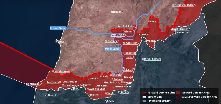
Jerusalem, April 20 (NationPress) The Israeli military has unveiled a detailed map outlining a proposed "buffer zone" intended to be established in southern Lebanon. This zone stretches several kilometers into Lebanese territory, creating a continuous barrier from the Mediterranean waters of Lebanon to the Mount Hermon region bordering Syria.
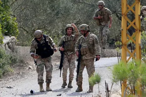
Prime Minister Benjamin Netanyahu and Defence Minister Israel Katz affirmed that Israeli troops will remain in the area, notwithstanding a temporary ceasefire that commenced at midnight between Thursday and Friday local time (2100 GMT). Katz also indicated that Israel would demolish homes and structures within this zone, drawing parallels to actions taken in the Gaza Strip, and issued a warning that anyone identified as a Hezbollah member would face lethal force, as reported by Xinhua news agency.
The military is currently deploying five divisions, complemented by naval forces, in Lebanese territory to create what they refer to as a "Forward Defense Line," which aims to "neutralize direct threats to the communities in northern Israel," according to an official military statement.
The map features a maritime section off the Naqoura-Ras al-Bayada coastline, highlighting a naval aspect of the operation.
This buffer zone extends beyond critical towns and cities such as Bint Jbeil, Aita al-Shaab, and Khiam, reaching toward the Litani River in certain areas, thereby encompassing numerous villages and ridge lines. Both Lebanon and Syria have rejected this initiative.
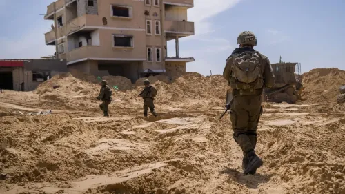
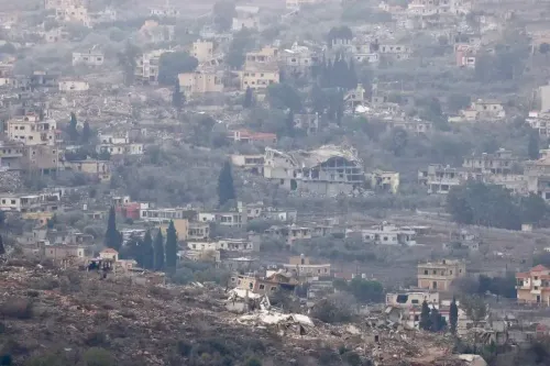
In spite of the ceasefire, Israeli military activities intensified in southern Lebanon on Sunday, as reported by Lebanon's National News Agency (NNA).
In Bint Jbeil, forces have continued the demolition of homes to "clear the security zone," with tanks patrolling the heavily affected city. Troops also detonated buildings in al-Bayada and al-Naqoura, obstructed roads using earth mounds, and shelled the town of Kounine.
There has been no immediate response from Israeli officials.
The map was released just three days after the United States announced a 10-day ceasefire between Israel and Hezbollah, who have been engaged in fierce clashes since early March. During a previous ceasefire initiated in November 2024, Israel persisted with near-daily strikes in southern and eastern Lebanon.
Point of View
We observe that Israel's strategic maneuvers in southern Lebanon reflect an urgent response to perceived threats. The announcement of a buffer zone, juxtaposed with ongoing military actions, underscores the complex dynamics at play in this volatile region.
NationPress
20 Jun 2026
Frequently Asked Questions
What is the purpose of the buffer zone?
The buffer zone aims to create a defensive line to thwart threats against northern Israeli communities.
How has Lebanon reacted to the buffer zone?
Lebanon has rejected the establishment of the buffer zone, indicating ongoing tensions.
What military operations are currently taking place?
Israeli forces are intensifying operations, including the demolition of structures and patrolling with tanks in southern Lebanon.
What led to the announcement of the 10-day ceasefire?
The ceasefire was announced by the United States following escalating violence between Israel and Hezbollah.
What areas does the buffer zone cover?
The buffer zone spans several kilometers into Lebanon, including areas around Bint Jbeil and the Litani River.