NISAR satellite data reveals Mexico City sinking over 2 cm per month

Synopsis
A joint NASA-ISRO radar satellite has caught Mexico City sinking at more than 2 cm per month — and scientists say this is just the beginning. NISAR's dual-frequency radar, the first of its kind, can see through clouds and vegetation, promising a global wave of subsidence discoveries that could reshape how cities plan for ground collapse and sea level rise.
Key Takeaways
The NISAR satellite recorded parts of Mexico City sinking at more than 2 cm per month between October 2025 and January 2026 .
Historical data show some areas subsided by about 35 cm per year in the late 20th century, damaging roads, buildings, and the Metro system.
The Angel of Independence monument, built in 1910 , has had 14 steps added at its base due to surrounding land sinking.
NISAR uses a dual-frequency radar — the first of its kind — capable of observing Earth's surface twice every 12 days , regardless of weather.
The satellite was launched in July 2025 from Satish Dhawan Space Centre , India, as part of a joint NASA-ISRO collaboration.
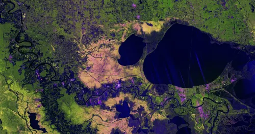
The joint NASA-ISRO satellite mission NISAR (NASA-ISRO Synthetic Aperture Radar) has captured fresh evidence of accelerating land subsidence in Mexico City, with certain parts of the metropolitan region sinking by more than 2 centimetres per month, according to new data released by NASA and ISRO on 30 April 2025. The findings, drawn from observations collected between October 2025 and January 2026, highlight both the severity of the capital's long-running subsidence crisis and the expanding capability of space-based radar systems to monitor ground movement in near real time.
What the NISAR Data Shows
The satellite's advanced dual-frequency radar system — the first of its kind — can penetrate cloud cover and dense vegetation, enabling scientists to track subtle surface changes irrespective of weather or lighting conditions. Data collected over the three-month observation window reveal that certain zones within Mexico City are sinking at a rate exceeding 2 cm per month, a figure that, if sustained, would translate to nearly 24 cm of subsidence annually in the worst-affected areas. The satellite is capable of observing Earth's land and ice surfaces twice every 12 days, providing an unprecedented frequency of ground-movement data.
A Century-Old Crisis, Now Monitored From Space
Mexico City, home to nearly 20 million people, has been sinking for more than a century. The primary drivers are intensive groundwater extraction and the compressive weight of urban development bearing down on its ancient lakebed foundation. Historical records show that some areas subsided by approximately 35 centimetres per year in the late 20th century, causing widespread damage to roads, buildings, and the city's extensive Metro system. One enduring physical marker of this long-term sinking is the Angel of Independence monument, built in 1910, which has required the addition of 14 steps at its base over the decades as surrounding ground levels dropped.
What Scientists and Officials Said
Craig Ferguson, deputy project manager at NASA Headquarters, said the early results validated the mission's design. "Images like this confirm that NISAR's measurements align with expectations," Ferguson said. "NISAR's long wavelength L-band radar will make it possible to detect and track land subsidence in more challenging and densely vegetated regions such as coastal communities where they may have the compounding effects of both land subsidence and sea level rise." David Bekaert, a project manager at the Flemish Institute for Technological Research and a member of the NISAR science team, described Mexico City as "a well-known hot spot when it comes to subsidence" and said the current images are "just the beginning for NISAR." He added: "We're going to see an influx of new discoveries from all over the world, given the unique sensing capabilities of NISAR and its consistent global coverage."
The India-US Space Partnership Behind NISAR
The NISAR mission represents one of the most significant space collaborations between India and the United States. NASA's Jet Propulsion Laboratory (JPL) led the American contribution, while ISRO provided key spacecraft components. The satellite was launched in July 2025 from India's Satish Dhawan Space Centre. Beyond subsidence monitoring, the mission is designed to track a broad range of geophysical processes — including shifting glaciers, agricultural changes, and ecosystem dynamics — delivering consistent global coverage that no previous radar satellite has matched.
What Comes Next
Scientists expect NISAR's consistent observation cadence to unlock a wave of new findings across multiple regions globally, particularly in coastal and densely vegetated areas where subsidence risk compounds with sea level rise. For Mexico City, the data could inform urgent infrastructure decisions, groundwater policy, and urban resilience planning. The mission's full science output is expected to grow substantially as the satellite completes more observation cycles in the months ahead.
Point of View
Globally comparable one. The real significance here is not a single data release but the cadence: twice every 12 days, cloud-penetrating, vegetation-piercing radar coverage that will make it nearly impossible for governments to claim ignorance of accelerating ground collapse. The harder question is whether data alone drives policy. Mexico City has had subsidence data for decades; what it has lacked is the political will to curb groundwater extraction. NISAR can sharpen the alarm — but it cannot pull the lever.
NationPress
2 Aug 2026
Frequently Asked Questions
What is the NISAR satellite and who built it?
NISAR (NASA-ISRO Synthetic Aperture Radar) is a joint Earth-observation satellite built by NASA's Jet Propulsion Laboratory and India's ISRO. It was launched in July 2025 from Satish Dhawan Space Centre in India and uses a dual-frequency radar system — the first of its kind — to monitor ground movement, glaciers, and other geophysical changes.
How fast is Mexico City sinking according to NISAR data?
NISAR data collected between October 2025 and January 2026 show that certain areas of Mexico City are sinking by more than 2 centimetres per month. Historically, some zones subsided by around 35 centimetres per year in the late 20th century.
Why is Mexico City sinking?
Mexico City has been sinking for over a century primarily due to intensive groundwater extraction and the weight of urban development compressing its ancient lakebed foundation. The city of nearly 20 million people sits on a drained lake, making it especially vulnerable to subsidence.
What makes NISAR different from previous Earth-observation satellites?
NISAR carries the first dual-frequency synthetic aperture radar system of its kind, capable of penetrating cloud cover and dense vegetation. It can observe Earth's land and ice surfaces twice every 12 days, enabling near-real-time tracking of subtle ground movements globally.
What are the broader implications of NISAR's subsidence findings?
Scientists say Mexico City is just the beginning, with NISAR expected to reveal subsidence patterns in coastal communities, densely vegetated regions, and areas where land sinking compounds with sea level rise. The data could inform infrastructure planning, groundwater policy, and urban resilience strategies worldwide.