How Are Blizzards and Extreme Cold Affecting Transport in Japan?

Synopsis
Severe winter weather is wreaking havoc on transportation in northern Japan. Blizzards and extreme cold are causing flight cancellations and rail service disruptions, raising concerns about ongoing weather conditions. Stay informed as we delve into how these harsh conditions are affecting everyday life in Japan.
Key Takeaways
Severe blizzards are disrupting rail services in northern Japan.
Flight cancellations at New Chitose Airport have reached 82.
Forecasts predict high winds and significant snowfall.
Precautions are advised for agriculture and livestock.
Weather conditions may impact daily life and travel.
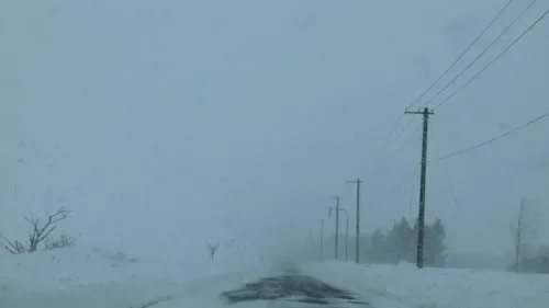
Tokyo, Jan 14 (NationPress) - Severe blizzards, powerful winds, and frigid temperatures have caused significant disruptions to rail services throughout northern Japan on Wednesday, as harsh winter conditions escalated around Hokkaido and regions along the Sea of Japan coast.
JR Hokkaido reported that 50 train services have been halted since Tuesday due to intense winds, drifting snow, and low temperatures. At New Chitose Airport, 82 flights departing and arriving have been canceled, with many others facing delays since Tuesday.
Officials have cautioned that whiteout conditions and significant snowdrifts might continue to disrupt transportation into the early hours of Thursday, as reported by the Xinhua news agency. Forecasts for Thursday predict maximum instantaneous wind speeds reaching up to 35 meters per second in southern regions along the Sea of Japan coast, with winds of up to 30 meters per second in northern areas and along the Pacific coast.
Over coastal waters, winds could reach 35 meters per second in eastern Pacific regions and the southern Okhotsk Sea, while surrounding seas may experience gusts of around 30 meters per second.
In the 24 hours leading up to Thursday morning, snowfall is expected to accumulate up to 40 centimeters in certain parts of both northern and southern regions along the Sea of Japan coast.
Meanwhile, China's national observatory forecasted significant temperature drops, strong winds, and snowfall in parts of Inner Mongolia and northeastern China provinces over the next 10 days, urging preparedness measures to mitigate potential adverse effects on local agriculture and livestock.
The National Meteorological Centre (NMC) indicated that during this period, temperatures in the affected areas are likely to be 2 to 5 degrees Celsius lower than the average levels of prior years, driven by recurring cold air waves.
The NMC also predicted sandy weather in Inner Mongolia and Gansu over the next week, necessitating precautionary measures against wind, cold, and sandstorms.
Meteorological experts have recommended that winter wheat-growing regions in the north implement structured management to ensure crop security. They also advised reinforcing greenhouse structures and livestock enclosures in advance to protect against the chilling effects in the northeastern provinces and Inner Mongolia.
Point of View
It's crucial to keep our audience informed about significant weather events that affect transportation and daily life. The severe winter conditions in Japan not only disrupt travel but also pose risks to local agriculture and livestock. Our commitment is to deliver timely and accurate information, ensuring that our readers are prepared and aware.
NationPress
24 Jun 2026
Frequently Asked Questions
What areas in Japan are most affected by the blizzards?
Northern Japan, particularly Hokkaido and regions along the Sea of Japan coast, are experiencing the most severe impacts from the blizzard conditions.
How many train services have been suspended?
Approximately 50 train services have been suspended across Hokkaido due to strong winds and snow.
What precautions should be taken during this weather?
Authorities advise travelers to stay updated on weather forecasts, avoid unnecessary travel, and ensure that agricultural and livestock facilities are prepared for the extreme cold.
What is the forecast for the coming days?
Continued blizzard conditions are expected, with significant snowfall and high winds predicted through Thursday.
What other areas are experiencing severe weather?
Parts of Inner Mongolia and northeastern China are also facing harsh weather, including significant temperature drops and strong winds.