Did a Massive 7.6 Magnitude Earthquake Strike the Philippines' Mindanao Region?

Synopsis
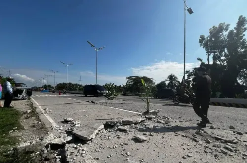
A powerful earthquake measuring 7.6 on the Richter scale rocked the Davao Oriental province in the Philippines. Experts warn of potential tsunami threats and aftershocks. Residents are urged to evacuate to safer areas. Read on for the latest updates and safety measures following this significant seismic event.
Key Takeaways
Magnitude: 7.6 earthquake in Mindanao.
Location: Davao Oriental province, Philippines.
Tsunami Threat: Potential hazardous waves within 300 km.
Precautions: Evacuate coastal areas.
Seismic Activity: Frequent due to the Pacific 'Ring of Fire'.
Manila, Oct 10 (NationPress) An offshore earthquake with a preliminary magnitude of 7.6 struck the Davao Oriental province in the Mindanao region of the Philippines on Friday morning, as reported by the Philippine Institute of Volcanology and Seismology. The earthquake occurred at 9:43 a.m. local time (0143 GMT) at a depth of 10 kilometers, approximately 62 kilometers east of Manay.
Initial assessments from the United States Geological Survey (USGS) and the European-Mediterranean Seismological Centre (EMSC) noted the quake's magnitude as 7.4, which was subsequently updated to 7.6 by the Philippine Institute of Volcanology and Seismology.
The institute indicated that tsunami waves could be possible for several hours, and the tectonic activity will likely trigger aftershocks. The US Tsunami Warning System has issued a tsunami threat, indicating that hazardous waves may impact coasts within 300 km (186 miles) of the earthquake's epicenter.
Teresito Bacolcol, the head of Philippine seismology, stated that a tsunami warning would be issued following the quake, which hit about 20 kilometers away from Manay at 9:43 a.m. local time (11:43 a.m. AEST). The forecast predicts one-meter waves along the Pacific coast in the next two hours, urging coastal residents in the affected area to evacuate to higher grounds or move inland. There are currently no reports of damage.
The Philippines experiences frequent seismic activity due to its position along the Pacific 'Ring of Fire'.
Point of View
It's critical to emphasize the importance of precautionary measures in the wake of natural disasters. The Philippine authorities are responding swiftly to ensure public safety, and we encourage residents to heed official warnings while remaining calm during this unpredictable situation.
NationPress
11 Jul 2026
Frequently Asked Questions
What was the magnitude of the earthquake?
The earthquake had a preliminary magnitude of 7.6 .
Where did the earthquake strike?
The earthquake struck in the Davao Oriental province, located in the Mindanao region of the Philippines .
Is there a tsunami warning?
Yes, the US Tsunami Warning System has issued a tsunami threat due to the earthquake.
What should residents do?
Residents in coastal areas are urged to evacuate to higher grounds or move farther inland.
When did the earthquake occur?
The earthquake occurred at 9:43 a.m. local time on October 10.