Mount Qomolangma Tourist Area Temporarily Closed Following 7.1 Magnitude Earthquake in Tibet
Lhasa, Jan 7 (NationPress) The Mount Qomolangma scenic area has been temporarily closed, ensuring that tourists and staff remain in a safe condition after a significant 7.1-magnitude earthquake struck Dingri County in the Xizang (Autonomous Region) on Tuesday morning, as stated by local Chinese authorities.
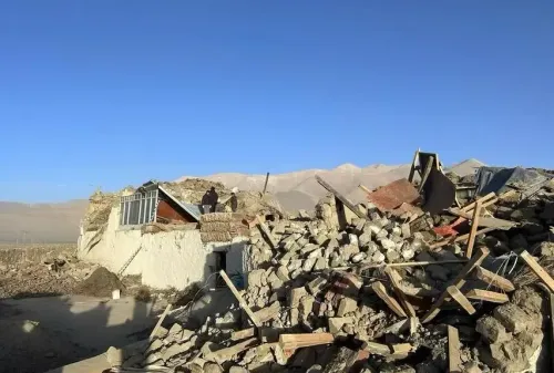
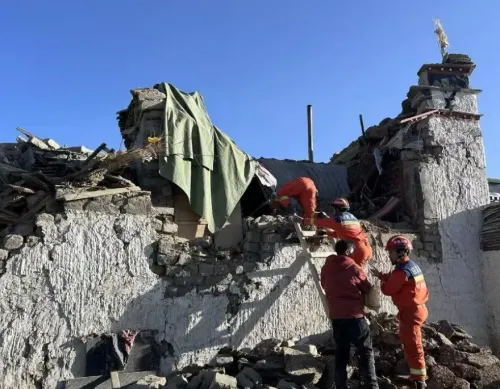
Dingri is recognized as the gateway to the base camp of the world’s tallest mountain. Reports indicate that 95 individuals have lost their lives and 130 have sustained injuries due to the earthquake, according to the regional disaster relief headquarters.
The hotel structures and nearby regions within the scenic area have remained unscathed, and both tourists and staff are confirmed to be safe, according to the Dingri Culture and Tourism Bureau.
The Qomolangma Station for Atmospheric and Environmental Research, operated by the Chinese Academy of Sciences and located in Dingri, is currently experiencing a power outage; however, the facilities are reported to be in good condition.
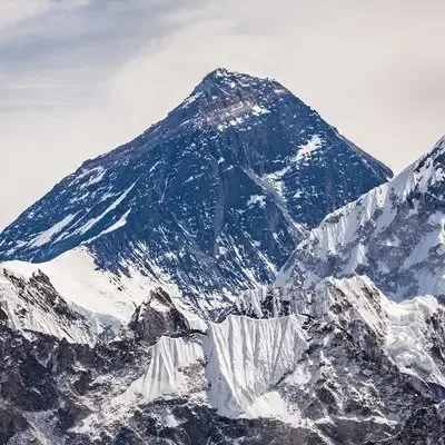
Positioned at the China-Nepal border, Mount Qomolangma rises to an elevation exceeding 8,840 meters, with its northern section situated in Xizang.
Recent weather forecasts indicate that Dingri's temperature is fluctuating between -18 degrees Celsius and 0 degrees Celsius.
In 2024, the Chinese side of Mount Qomolangma welcomed 13,764 overseas tourists, which is more than double the number recorded in 2023. This surge is a clear indicator of the revitalization of international tourism following China's easing of visa regulations.
As reported by the County Bureau of Culture and Tourism, tourists primarily hail from countries including Singapore, Malaysia, Germany, and France, according to Xinhua news agency.
The National Centre for Seismology (NCS) confirmed that the earthquake occurred at 6:35 a.m. (IST), with its epicenter located at latitude 28.86°N and longitude 87.51°E, at a depth of 10 km. The location was identified as Xizang (Tibet Autonomous Region), close to the Nepal border.
Reports indicate that fatalities were predominantly in the city of Xizang, with numerous injuries and structural damage also reported.
In Tonglai Village, Changsuo Township of Dingri in Xigaze (Shigatse), several homes have reportedly collapsed.
The earthquake also generated tremors across northern India, affecting regions such as Bihar, West Bengal, Sikkim, and Delhi-NCR, causing panic as residents evacuated their homes. Fortunately, no casualties or property damage have been reported in India to date.
Two aftershocks followed the initial quake: a 4.7-magnitude tremor was recorded at 7:02 a.m. (IST), with an epicenter at latitude 28.60°N and longitude 87.68°E, at a depth of 10 km, and another 4.9-magnitude quake struck at 7:07 a.m. (IST), with an epicenter at latitude 28.68°N and longitude 87.54°E, at a depth of 30 km.
The United States Geological Survey (USGS) identified the earthquake’s location as 93 km northeast of Lobuche, near the Nepal-Tibet border. Lobuche is situated close to the Khumbu Glacier, approximately 150 km east of Kathmandu and 8.5 km southwest of Everest Base Camp.
Nepal, which is located in a highly seismically active region where the Indian and Eurasian tectonic plates converge, frequently experiences earthquakes. This tectonic activity, responsible for creating the Himalayan region, often results in seismic occurrences of varying magnitudes.