What Are the Implications of Typhoon Tapah's Level-IV Warning in China's Hainan?
Synopsis
As Typhoon Tapah intensifies, Hainan's Level-IV warning highlights the seriousness of this natural disaster. The approaching storm, with winds of up to 23 m/s, could significantly impact the coastal regions. Stay informed about the latest developments and safety measures as this situation unfolds.
Key Takeaways
Typhoon Tapah is the 16th typhoon of the year.
Hainan has issued a Level IV warning .
The typhoon is expected to make landfall in Guangdong.
Winds may reach up to 23 meters per second .
Emergency response teams are deployed for relief efforts.
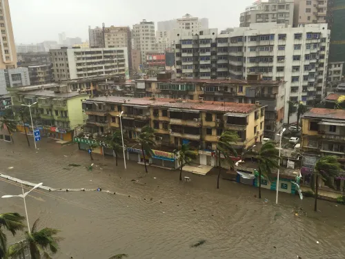
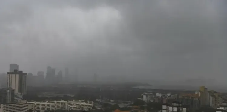
Beijing, Sep 7 (NationPress) As Typhoon Tapah, the 16th typhoon of the season, has developed, the island province of Hainan in China issued a Level IV typhoon warning at 8 a.m. on Sunday.
At 7 a.m. on that day, the eye of Typhoon Tapah was situated over the South China Sea, roughly 445 kilometres southeast of Dianbai District in Maoming City, located in southern Guangdong Province, with maximum wind speeds reaching 23 meters per second near its center, as reported by the Hainan provincial meteorological observatory.
Forecasts indicate that Typhoon Tapah will progress northwestward at a pace of 10 to 15 kilometres per hour while gradually intensifying, according to Xinhua news agency.
The typhoon is anticipated to near the coastal regions of central and western Guangdong, making landfall between Zhuhai and Zhanjiang from early Sunday morning to noon as either a severe tropical storm or typhoon. After landfall, its intensity is expected to diminish, according to weather authorities.
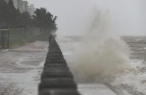
Due to the typhoon's influence, the Qiongzhou Strait and Beibu Gulf will experience easterly winds of force five, with gusts surging to force seven to eight amid thunderstorms.
Wind strengths in the eastern waters of Hainan Island will gradually rise to force seven to nine, with gusts potentially reaching force 10 to 11. The sea areas surrounding the Xisha and Zhongsha Islands will also see escalating wind forces, reaching force six to eight with gusts of force eight to ten.
China employs a four-tier emergency response framework, with Level I indicating the most critical response.
On Saturday, the nation also initiated a Level-IV emergency response to address flooding and typhoon impacts in both Guangdong and Hainan provinces.
The State Flood Control and Drought Relief Headquarters has dispatched teams to Guangdong to bolster local flood and typhoon relief operations.
A tropical depression that emerged on the South China Sea on Friday evening is on track to strengthen into this year's 16th typhoon by Saturday. It is predicted to make landfall between Sunday night and Monday morning along the central and western coasts of Guangdong, bringing heavy rainfall and strong winds in the upcoming days.
Point of View
It is crucial to convey the urgency of Typhoon Tapah's impact on Hainan. Our responsibility is to ensure that citizens receive timely and accurate information, allowing them to respond effectively to this natural threat. We stand with the nation in prioritizing safety and preparedness during this challenging time.
NationPress
30 Jun 2026
Frequently Asked Questions
What is Typhoon Tapah?
Typhoon Tapah is the 16th typhoon of the year, currently forming over the South China Sea with significant wind speeds.
What areas are affected by the Level-IV warning?
The Level-IV warning affects the island province of Hainan and parts of Guangdong Province.
What safety measures should residents take?
Residents should secure loose items, prepare emergency kits, and stay updated on local weather reports.
How does China's emergency response system work?
China has a four-tier emergency response system, with Level I being the most severe, implemented during critical situations.
When is Typhoon Tapah expected to make landfall?
Typhoon Tapah is forecasted to make landfall between Sunday night and Monday morning.