Gujarat digital crop survey 2026: 95 lakh plots mapped from Aug 15
Synopsis
Gujarat is mapping over 95 lakh agricultural plots in 45 days — the most ambitious digital crop exercise the state has run. Launched on Independence Day under the Centre's AgriStack framework, the survey lets farmers geo-tag their own fields via a mobile app, potentially transforming how crop insurance, subsidies, and credit reach India's farmers.
Key Takeaways
Gujarat's 45-day digital crop survey begins on 15 August 2026 and runs until 30 September 2026 .
The survey covers more than 95 lakh agricultural plots across 18,197 villages in all districts of the state.
It is part of the Centre's AgriStack initiative, which Gujarat has been implementing since 2024-25 .
Designated government surveyors will upload geo-tagged photographs of crops through a digital application.
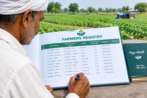
Farmers registered in the Farmer Registry can self-survey using the Digital Crop Survey mobile app .
The Directorate of Agriculture has urged all farmers to complete registration by 30 September 2026 .
Gujarat will launch a 45-day statewide digital crop survey on 15 August 2026, covering more than 95 lakh agricultural plots across 18,197 villages under the Centre's AgriStack initiative, the state government announced on Monday. The Kharif-2026 survey will run continuously until 30 September 2026, digitally recording crop details across all districts of the state.
Scope and Coverage
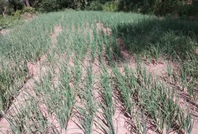
The exercise spans every eligible cultivable plot identified for the Kharif season across Gujarat's districts. Designated government surveyors will visit each field or survey number, uploading crop information — including geo-tagged photographs — through a dedicated digital application. This ensures cultivation details are recorded with locational precision at the individual plot level.
How Farmers Can Participate
Farmers registered in the Farmer Registry are not required to wait for a designated surveyor. They can download the Digital Crop Survey application on their mobile phones and self-register details of crops cultivated on their land. The Directorate of Agriculture has appealed to all farmers to ensure that every survey number under their ownership is covered by 30 September 2026 — either through the village-level surveyor or through self-submission via the app.
Background: AgriStack and Gujarat's Digital Push
Gujarat has been conducting digital crop surveys since 2024-25 as part of the Centre's broader AgriStack project, which aims to build a unified digital infrastructure for Indian agriculture. AgriStack is designed to link farmer identities, land records, and crop data into a single interoperable system — enabling more targeted subsidy delivery, crop insurance processing, and agricultural credit access. The current Kharif-2026 exercise is the latest and most expansive iteration of this effort in the state.
Why This Survey Matters
Accurate, real-time crop data at the plot level has long been a gap in Indian agricultural administration. Historically, crop assessments relied on manual patwari records, which were prone to delays and inaccuracies. A geo-tagged digital record of 95 lakh-plus plots could significantly improve the speed and accuracy of crop loss assessments during natural calamities, streamline PM Fasal Bima Yojana claims, and reduce leakages in input subsidy distribution. Notably, this is the second consecutive Kharif season for which Gujarat is conducting the survey at this scale.
Next Steps
With the survey window closing on 30 September 2026, farmers and surveyors have a firm 45-day deadline. The government has urged maximum farmer participation to ensure complete coverage. Data collected is expected to feed into the national AgriStack database, with downstream benefits for credit, insurance, and welfare scheme targeting anticipated in the subsequent Rabi season.
Point of View
But the harder question is what happens to the data after 30 September. AgriStack's promise — faster insurance settlements, targeted subsidies, reduced leakage — depends entirely on back-end integration that the Centre has yet to demonstrate at scale. Two Kharif seasons in, the data is being collected; the downstream pipeline that should convert geo-tagged photographs into farmer benefits remains largely unproven. The real test of this exercise is not coverage — it is whether a farmer in Saurashtra sees a faster crop-loss claim the next time a cyclone hits.
NationPress
25 Sept 2026
Frequently Asked Questions
What is the Gujarat digital crop survey 2026?
It is a 45-day statewide exercise beginning 15 August 2026, in which government surveyors and farmers digitally record crop details — including geo-tagged photographs — for more than 95 lakh agricultural plots across 18,197 villages. The survey covers the Kharif-2026 season and runs until 30 September 2026.
What is the AgriStack initiative and how does Gujarat fit in?
AgriStack is a central government project to build a unified digital infrastructure linking farmer identities, land records, and crop data across India. Gujarat has been participating since 2024-25, and the Kharif-2026 survey is its most expansive implementation to date.
How can farmers participate in the digital crop survey?
Farmers registered in the Farmer Registry can download the Digital Crop Survey application on their mobile phones and self-register their crop details without waiting for a government surveyor. They must complete this by 30 September 2026.
Why does accurate digital crop data matter for farmers?
A geo-tagged plot-level record can speed up crop loss assessments after natural calamities, streamline PM Fasal Bima Yojana insurance claims, and reduce leakages in subsidy distribution — benefits that historically suffered due to delays in manual patwari records.
What is the deadline for the Kharif-2026 crop survey in Gujarat?
The survey window closes on 30 September 2026. The Directorate of Agriculture has urged farmers to ensure all their survey numbers are covered by that date, either through the designated village surveyor or via the self-survey mobile app.