Haryana geo-references 96% villages under AgriStack, 1.75 crore plots mapped
Synopsis
Haryana has geo-referenced 1.75 crore agricultural plots covering 96% of its villages under AgriStack — and with a 6,500-surveyor Kharif 2026 digital crop survey launching in August, the state is racing to build India's most comprehensive state-level farmer data backbone before the next cropping season begins.
Key Takeaways
Haryana has geo-referenced 1.75 crore agricultural plots across 6,808 of 7,100 villages — 95.89% coverage — under the AgriStack programme.
More than 11.58 lakh farmers enrolled; 8.32 lakh farmer identity documents generated to date.
Remaining villages to be covered within the next two months , according to Chief Secretary Anurag Rastogi .
Kharif 2026 Digital Crop Survey to cover all geo-referenced plots in 23 districts , with 6,500 surveyors set to begin in August 2026 .
1.75 crore Revenue Department farmer records will be used to expand registry coverage beyond PM-KISAN beneficiaries.
Haryana has geo-referenced 1.75 crore agricultural plots across 6,808 of its 7,100 villages — achieving 95.89% coverage — under the AgriStack digital agriculture programme, state officials confirmed on Thursday, 18 June. More than 11.58 lakh farmers have been enrolled in the farmer registry, and 8.32 lakh farmer identity documents have been generated so far. The remaining villages are expected to be covered within the next two months.
Key Developments
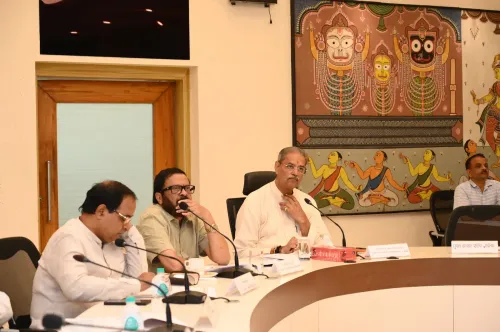
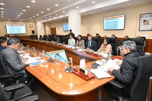
The progress was reviewed at a steering committee meeting chaired by Chief Secretary Anurag Rastogi in Chandigarh. Rastogi described the AgriStack initiative as laying the foundation for a transparent, data-driven agricultural administration by integrating farmer records, land ownership details, and crop information onto a single digital platform. Once fully operational, the system is expected to enable faster delivery of government benefits, reduce duplication, and sharpen the targeting of welfare schemes.
Financial Commissioner (Revenue) Sumita Misra informed the committee that enrolment under the farmer registry is being accelerated through a network of common service centres across the state. With these centres now actively undertaking registrations, the pace of enrolment is expected to increase substantially in the coming weeks.
Digital Crop Survey Preparations
The meeting also reviewed preparations for the Kharif 2026 Digital Crop Survey, which will cover all geo-referenced plots across 23 districts. Approximately 6,500 surveyors are expected to participate in the exercise, which is scheduled to commence in August 2026. The digital mapping exercise is considered a key prerequisite for this survey and for the creation of a verified farmer registry.
Officials noted that nearly 1.75 crore farmer records available in the Revenue Department database will be leveraged to broaden coverage of the registry — including farmers who are not beneficiaries under the PM-KISAN scheme, ensuring wider inclusion.
What the Government Said
Chief Secretary Rastogi directed officers to ensure expeditious disposal of pending verification cases and to achieve saturation of the farmer registry by linking all land parcels to existing and newly generated farmer identity documents in mission mode. He also emphasised the need for robust district-level monitoring and directed officials to hold regular review meetings to meet the set targets.
Rastogi underlined that the integration of land records, crop data, and farmer databases would create a reliable digital backbone for agriculture and strengthen evidence-based decision-making in the sector.
Impact on Farmers and Administration
The AgriStack framework is designed to eliminate duplicate beneficiary records and plug leakages in subsidy delivery — a persistent challenge in large-scale agrarian welfare programmes. By tying farmer identity documents directly to geo-referenced land parcels, the state aims to make benefit transfers faster and more verifiable. This comes amid a broader national push to digitise agricultural data, with several states piloting similar land-record integration models under central guidance.
With the Kharif survey approaching and enrolment being scaled up, the next two months will be critical in determining whether Haryana achieves full saturation ahead of the cropping season.
Point of View
But the harder test lies ahead: linking all land parcels to verified farmer identities before the Kharif survey in August. Past digitisation drives in Indian agriculture have stalled at exactly this last-mile verification stage, where disputed land records and absentee landowners create bottlenecks. The state's decision to loop in farmers outside PM-KISAN is the right instinct — welfare schemes that exclude non-beneficiary smallholders routinely undercount the actual farming population. Whether the common service centre network can absorb the enrolment surge without quality loss will determine if this becomes a genuine data backbone or another incomplete registry.
NationPress
19 Sept 2026
Frequently Asked Questions
What is the AgriStack programme in Haryana?
AgriStack is a digital agriculture initiative that integrates farmer records, land ownership details, and crop data on a single platform. In Haryana, it involves geo-referencing agricultural plots and creating a verified farmer registry to enable faster, more accurate delivery of government welfare schemes.
How many villages has Haryana covered under AgriStack so far?
As of 18 June, Haryana has geo-referenced 6,808 of its 7,100 villages, achieving 95.89% coverage. The remaining villages are expected to be covered within the next two months.
What is the Kharif 2026 Digital Crop Survey?
The Kharif 2026 Digital Crop Survey is a state-wide exercise set to begin in August 2026, covering all geo-referenced plots across 23 districts of Haryana. Around 6,500 surveyors are expected to participate, and the survey depends on the completion of the ongoing village geo-referencing exercise.
Who is eligible for enrolment in the Haryana farmer registry?
The registry covers all farmers in Haryana, not just PM-KISAN beneficiaries. Officials plan to use 1.75 crore farmer records from the Revenue Department database to ensure broader inclusion of smallholders and other farmers currently outside central scheme coverage.
How will AgriStack benefit farmers?
Once fully operational, AgriStack is expected to reduce duplication in beneficiary records, speed up subsidy and welfare transfers, and improve targeting of government schemes. By linking land parcels to verified farmer identities, it aims to eliminate leakages and enable evidence-based agricultural policy.