
IMD issues heavy rain alert for 10 Tamil Nadu districts on May 15-16

Synopsis
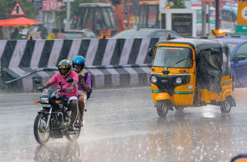
A low-pressure system brewing over the southwest Bay of Bengal is set to bring heavy rain and thunderstorms to 10 Tamil Nadu districts on May 15 and 16. With interior and western districts in the crosshairs and fishermen advised to stay alert, this is the most significant pre-monsoon weather event to hit the state this season.
Key Takeaways
The IMD has issued a heavy rainfall warning for 10 Tamil Nadu districts on 15 and 16 May .
Affected districts include Nilgiris, Coimbatore, Erode, Tiruppur, Thanjavur, Tiruvarur, Nagapattinam, Pudukkottai, Ramanathapuram , and Sivaganga .
A low-pressure area over the southwest Bay of Bengal near Sri Lanka is expected to intensify over the next 48 hours .
Fishermen have been advised to monitor weather updates before venturing into the sea.
Chennai temperatures are likely to stay below 37°C over the next two days, offering partial relief from summer heat.
The India Meteorological Department (IMD) has warned that a low-pressure area formed over the southwest Bay of Bengal near the Sri Lankan coast is likely to intensify over the next 48 hours, raising the prospect of heightened rainfall activity across several parts of Tamil Nadu in the coming days. The alert was issued on Tuesday, 12 May, by the Regional Meteorological Centre (RMC).
Heavy Rainfall Warning for 10 Districts
The IMD has issued a heavy rainfall warning for 10 Tamil Nadu districts on 15 and 16 May. Thunderstorms accompanied by heavy rain are forecast in Nilgiris, Coimbatore, Erode, Tiruppur, Thanjavur, Tiruvarur, Nagapattinam, Pudukkottai, Ramanathapuram, and Sivaganga during this period. Weather officials noted that rainfall activity could intensify particularly in interior and western districts due to localised convection and moisture incursion triggered by the evolving low-pressure system.
System Likely to Strengthen Gradually
The RMC stated that the weather system, which developed over the southwest Bay of Bengal adjoining Sri Lanka, is expected to strengthen gradually into a more active weather system over the next two days. However, officials clarified that there is currently no immediate threat of severe weather conditions over Tamil Nadu. The department has forecast moderate rainfall at isolated places in the southern coastal districts and delta regions of Tamil Nadu over the next four days under the influence of the evolving system.
Advisory for Fishermen and Coastal Areas
Fishermen have been advised to closely follow weather updates before venturing into the sea, as conditions may turn rough in parts of the Bay of Bengal adjoining the Tamil Nadu coast. The prevailing atmospheric conditions are expected to enhance moisture inflow from the Bay, leading to intermittent rain and cloudy skies across several regions.
Chennai Weather and Broader Context
Chennai is expected to witness partly cloudy to generally cloudy skies over the next two days, with maximum temperatures likely to remain below 37 degrees Celsius, offering slight relief from the prevailing summer heat. This latest development comes amid increasing pre-monsoon weather activity across south India, with several regions already experiencing scattered showers, gusty winds, and thunderstorms over the past week. Meteorologists are continuing to closely monitor the movement and intensity of the low-pressure system as it evolves over the Bay of Bengal.
Point of View
Yet the 10-district alert for May 15-16 signals that this low-pressure system carries real disruption potential for Tamil Nadu's agricultural heartland. Districts like Nagapattinam and Thanjavur, which lie in the Cauvery delta, are particularly vulnerable to waterlogging even from moderate heavy-rain events. The fishermen advisory is a telling detail: rough Bay conditions often precede a system's intensification faster than forecast models project. Authorities and district administrations would do well to pre-position relief infrastructure rather than wait for an upgrade in the system's classification.
NationPress
12 May 2026
Frequently Asked Questions
Which Tamil Nadu districts are under IMD heavy rain alert on May 15 and 16?
The IMD has issued a heavy rainfall warning for Nilgiris, Coimbatore, Erode, Tiruppur, Thanjavur, Tiruvarur, Nagapattinam, Pudukkottai, Ramanathapuram, and Sivaganga for May 15 and 16. Thunderstorms are expected alongside heavy rain in these districts.
What is the low-pressure system over the Bay of Bengal?
It is a weather system that has formed over the southwest Bay of Bengal near the Sri Lankan coast. According to the IMD, it is likely to intensify further over the next 48 hours, enhancing rainfall activity across Tamil Nadu.
Is there a cyclone threat to Tamil Nadu?
No. IMD officials have clarified that there is currently no immediate threat of severe weather conditions over Tamil Nadu. The low-pressure area may strengthen gradually, but no cyclone warning has been issued as of 12 May.
What is the weather forecast for Chennai?
Chennai is expected to see partly cloudy to generally cloudy skies over the next two days, with maximum temperatures likely to stay below 37 degrees Celsius, providing some relief from the summer heat.
What advisory has been issued for fishermen?
Fishermen have been advised to closely monitor weather updates before venturing into the Bay of Bengal, as sea conditions may turn rough along the Tamil Nadu coast due to the evolving low-pressure system.