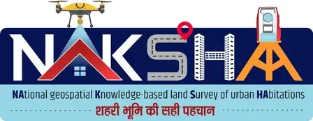
How Will NAKSHA Transform Urban Land Governance?
Click to start listening
Synopsis
A groundbreaking initiative in urban land governance is underway with the launch of the NAKSHA Programme. This two-day workshop aims to prepare District Magistrates and Collectors for a transformative shift powered by geospatial mapping and data analytics. Explore how this program will bring transparency and efficiency to land management.
Key Takeaways
- NAKSHA Programme aims to enhance urban land governance.
- Focus on geospatial mapping and data analytics.
- Workshop prepares officials for effective implementation.
- Goals include resolving ownership issues and streamlining taxation.
- Initiative promotes ‘One Nation, One Land Record’.
New Delhi, Oct 6 (NationPress) The government has initiated a two-day training workshop aimed at District Magistrates and Collectors, equipping them for the nationwide launch of the NAKSHA Programme. This initiative seeks to revolutionize urban land governance by integrating advanced geospatial mapping and data analytics.
NAKSHA is a year-long pilot project under the Digital India Land Records Modernisation Programme, designed to enhance transparency, efficiency, and accessibility in urban land governance, as stated by the Ministry of Rural Development.
The workshop, co-hosted by the Lal Bahadur Shastri National Academy of Administration and the Department of Land Resources, aims to prepare participants for the programme’s comprehensive rollout across the country.
The NAKSHA Programme intends to resolve ownership ambiguities, optimize property taxation, and lay a solid groundwork for future urban planning and governance by utilizing state-of-the-art geospatial mapping, GNSS (Global Navigation Satellite System), and Web-GIS technologies.
This initiative represents a significant leap towards the concept of ‘One Nation, One Land Record’, ensuring that every urban land parcel is digitally mapped and verified, according to the ministry’s announcement.
The workshop will delve into the technical, legal, and administrative aspects of the NAKSHA initiative, promoting an exchange of knowledge between field officers and industry experts.
Participants will receive a comprehensive overview of the NAKSHA Programme, including its workflow, deliverables, and verification processes, as per the ministry’s communication.
In addition, the technical training will encompass an introduction to GIS and Web-GIS tools, with hands-on demonstrations of modern surveying methods like GNSS/ETS for land parcel assessments.
Experts will also provide practical insights into aerial data collection and address challenges encountered in the field, as informed by the ministry.
Sessions will further address the necessary administrative and legal frameworks for implementing NAKSHA, along with best practices for awareness initiatives.
Point of View
I believe that the NAKSHA Programme aligns with our national vision of digital empowerment and efficient governance. By leveraging technology, we can ensure a transparent land management system, crucial for urban development and sustainable growth.
NationPress
07/10/2025
Frequently Asked Questions
What is the NAKSHA Programme?
The NAKSHA Programme is a pilot initiative under the Digital India Land Records Modernisation Programme, aimed at enhancing urban land governance through geospatial mapping and data analytics.
Who is involved in the training workshop for NAKSHA?
The training workshop is designed for District Magistrates and Collectors, co-organized by the Lal Bahadur Shastri National Academy of Administration and the Department of Land Resources.
What are the main objectives of NAKSHA?
The main objectives of NAKSHA include resolving ownership ambiguities, optimizing property taxation, and establishing a foundation for future urban planning and governance.
How will technology be utilized in NAKSHA?
NAKSHA will utilize advanced geospatial mapping, GNSS, and Web-GIS tools to digitally map and authenticate urban land parcels.
What is the significance of 'One Nation, One Land Record'?
This concept aims to create a unified digital record for every parcel of urban land, ensuring transparency and accessibility in land governance.