How Will NISAR Benefit the World According to Jitendra Singh?

Synopsis
The NISAR satellite, a joint project of NASA and ISRO, represents a major breakthrough in disaster management and environmental monitoring. Jitendra Singh's remarks emphasize its global impact and technological capabilities.
Key Takeaways
NISAR is a collaboration between NASA and ISRO.
The satellite weighs 2,392 kilograms .
It will monitor the Earth every 12 days .
Utilizes SweepSAR technology for high-resolution imagery.
Expected to enhance global disaster management efforts.
New Delhi, July 30 (NationPress) Union Minister of State for Science and Technology, Jitendra Singh, referred to the NASA-ISRO Synthetic Aperture Radar (NISAR) satellite as a transformative advancement in the effective management of natural disasters. Singh made this statement on Wednesday.
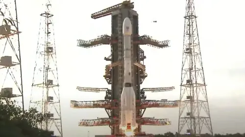
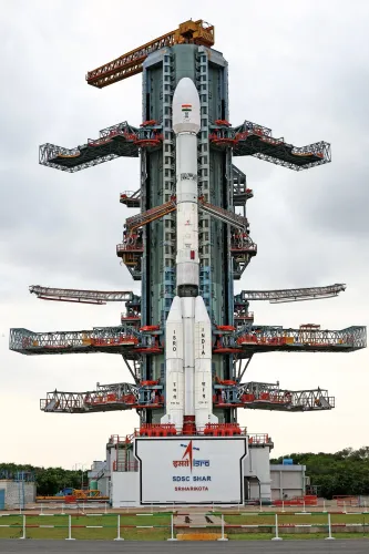
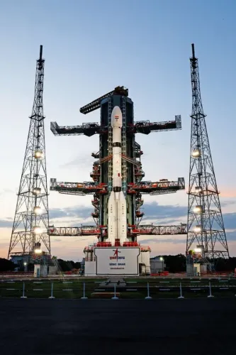
NISAR represents the inaugural collaborative Earth observation initiative between ISRO and NASA, harnessing the strengths and capabilities of both organizations. It was successfully launched aboard the GSLV-F16 rocket from the Satish Dhawan Space Centre, located in Sriharikota, Andhra Pradesh, at 5:40 PM.
“Kudos to India! The successful launch of #GSLV-F16 carrying the world’s pioneering dual-band radar satellite #NISAR is a revolutionary tool in the precise management of disasters including cyclones and floods,” Singh shared via social media platform X.
Approximately 19 minutes post-launch, the GSLV-F16 rocket deployed the NISAR satellite into a 743-km sun-synchronous orbit, marking the GSLV’s first mission into a Sun-Synchronous Orbit (SSO).
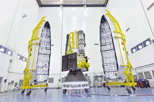
Weighing 2,392 kilograms, this satellite will survey the Earth’s landmass and ice-covered regions every 12 days, providing high-resolution imagery across a 242-kilometre path, utilizing SweepSAR technology for the first time.
“NISAR’s ability to penetrate through fog, dense clouds, and ice layers establishes it as a groundbreaking asset for the aviation and shipping industries. The data generated by NISAR will serve the global community in the true spirit of 'Vishwabandhu’,” Singh remarked.
He also expressed his pride in being “part of the Department of Space during a time when ISRO is achieving significant global milestones.”
NISAR will facilitate ongoing monitoring of environmental disturbances and assist in evaluating natural hazards such as earthquakes, tsunamis, volcanic eruptions, and landslides. It will also track subtle shifts in the Earth’s crust and surface movement.
The satellite's data will be leveraged for applications like sea ice classification, ship detection, shoreline monitoring, storm tracking, crop mapping, and assessing changes in soil moisture.
Anil Prakash, Director General of SIA-India, commended the NISAR mission and the collaboration between ISRO and NASA.
“The successful partnership on the $1.5 billion NISAR mission signifies a pivotal moment in global space diplomacy, merging advanced American L-band SAR systems with India’s engineering, integration, and cost-effective launch capabilities using GSLV-F16,” Prakash stated.
“ISRO’s contributions—including the S-band radar, satellite bus, launch services, and mission operations—once more highlight India’s capacity to develop and deliver intricate systems with exceptional reliability. With a legacy of over 400 international satellite launches, ISRO has positioned itself not merely as a partner, but as a co-architect of next-generation Earth science initiatives,” he added.
Point of View
The successful launch of NISAR showcases India's growing prowess in space exploration and technological innovation. This collaborative effort between ISRO and NASA not only enhances India's global standing but also demonstrates the importance of international partnerships in addressing pressing global challenges such as natural disaster management.
NationPress
20 Jun 2026
Frequently Asked Questions
What is the NISAR satellite?
The NISAR satellite is a joint Earth observation mission between NASA and ISRO designed to monitor the Earth's landmass and ice-covered surfaces.
What are the primary functions of NISAR?
NISAR will assist in monitoring natural disasters, assessing ecosystem disturbances, and providing high-resolution imagery for various applications.
How does NISAR contribute to disaster management?
NISAR's ability to penetrate through fog and dense clouds allows for better tracking and management of disasters such as cyclones and floods.
What is the significance of the NISAR mission?
The NISAR mission represents a significant milestone in global space diplomacy and showcases India's engineering capabilities.
How will NISAR impact global communities?
The data from NISAR will be utilized globally for various purposes including environmental monitoring and disaster response.