Maharashtra CM Fadnavis warns of 90 kmph winds, cloudburst threat in Nashik

Synopsis
A Bay of Bengal deep depression is battering Maharashtra with record-breaking fury — Mumbai has matched its entire monthly rainfall in just four days, six people have died in a Mankhurd collapse, and Nashik now faces a 300 mm cloudburst threat. With 90 kmph winds, eight landslide points on the Mumbai-Goa Highway, and trains suspended in Palghar, the next 48 hours are the state's most critical this monsoon.
Key Takeaways
Maharashtra CM Devendra Fadnavis warned of winds peaking at 90 kmph in Mumbai and surrounding areas on 7 July 2025 .
The IMD upgraded Mumbai's alert to a 'Red Alert' ; similar alerts are active for Pune , Raigad , Thane , and Palghar .
Nashik faces a 300 mm cloudburst threat on Tuesday; state-wide high alert remains in force until 8 July .
A structural collapse in Mankhurd slum claimed six lives ; the Savitri River and four others have breached danger marks.
Landslides at eight spots on the Mumbai-Goa Highway and 100 tonnes of debris on the Mumbai-Pune Expressway are disrupting key transport corridors.
Trains from Gujarat into Palghar have been suspended due to severe waterlogging.
Maharashtra Chief Minister Devendra Fadnavis on Monday, 7 July 2025, cautioned residents of Mumbai and surrounding districts of extremely high-velocity winds peaking at nearly 90 kmph, while also flagging a serious cloudburst risk in Nashik ahead of what forecasters say could be the region's most intense rainfall event this monsoon season. The warning came after large parts of Maharashtra entered their fifth consecutive day of torrential downpours.
Red Alert Across Multiple Districts
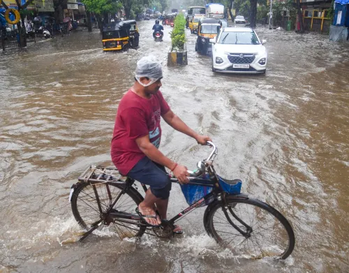
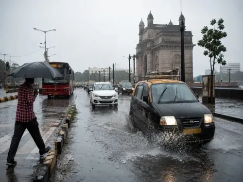
The India Meteorological Department (IMD) upgraded Mumbai's weather alert from an 'Orange Alert' to a 'Red Alert' on Monday following a sharp deterioration in conditions. Red Alerts have also been issued for Pune, Raigad, Thane, and Palghar districts. Heavy rains have lashed Mumbai for five consecutive days, with the city recording rainfall equivalent to its entire monthly average in just four days, according to the Chief Minister.
Bay of Bengal Depression Driving the Fury
Speaking to reporters after a comprehensive emergency review alongside Disaster Management Minister Girish Mahajan, Chief Minister Fadnavis attributed the sudden escalation to a low-pressure system over the Bay of Bengal that has since intensified into a deep depression. Because the system's primary impact zone heavily blankets the Konkan coast, the region is bearing the brunt of ferocious gusts. A scheduled high tide on the Mumbai coast compounded concerns, with officials warning that simultaneous heavy rainfall during the high-tide window could trigger severe waterlogging in low-lying areas.
Cloudburst Warning for Nashik, High Alert Until July 8
The IMD has predicted 300 mm of rainfall in Nashik on Tuesday, primarily driven by a cloudburst event. In response, the district administration has escalated preparedness across Nashik city, the wider district, and rural zones. 'High-alert status remains active across the state until 8 July,' Fadnavis said. He urged citizens — particularly youngsters — to avoid waterfalls and trekking spots during the hazardous period, and appealed to all residents to refrain from non-essential travel.
Landslides, Floods, and Infrastructure Damage
The severe weather has triggered multiple landslides on key transport corridors. On the Mumbai-Goa Highway, a major landslide at Kashedi Ghat blocked traffic; debris clearance is underway. The highway has reportedly witnessed landslides at eight distinct spots — a scale described as unprecedented. On the Mumbai-Pune Expressway, emergency crews are clearing nearly 100 tonnes of debris, with three lanes toward Pune kept operational. In Palghar, severe waterlogging has forced the suspension of trains arriving from Gujarat, while water accumulation has also been reported along the under-construction Ahmedabad-Mumbai highway.
Mankhurd Tragedy and Broader Relief Operations
The Chief Minister referenced the tragedy at Mankhurd, where a structural collapse in a slum claimed six lives, underscoring the human cost of the ongoing crisis. 'We have issued alerts across all sectors,' Fadnavis said. He confirmed that the state administration has comprehensively reviewed mitigation and relief plans deployed by the disaster management cell, district collectors, and divisional administrations. In Raigad, heavy downpours have brought life to a standstill, while Mahabaleshwar and Lonavala have registered rainfall far exceeding seasonal averages. The Savitri River and four other major rivers have breached their danger marks, though authorities say immediate flooding has been contained.
With the deep depression over the Bay of Bengal showing no signs of rapid weakening, Maharashtra's administration faces a critical 48-hour window as the state braces for further escalation before conditions are expected to ease after 8 July.
Point of View
Landslides at eight highway points simultaneously, and a deep depression still active — points to a systemic stress test for Maharashtra's disaster infrastructure that annual monsoon drills have not fully prepared it for. The Mankhurd collapse is a reminder that informal settlements remain the most exposed and the least served by early-warning systems. Fadnavis's public appeal to avoid waterfalls is necessary, but the harder accountability question is whether the under-construction Ahmedabad-Mumbai highway and the Mumbai-Goa Highway's chronic landslide-prone stretches had adequate pre-monsoon safeguards in place. A 48-hour window before conditions ease is not just a weather forecast — it is a deadline for the administration.
NationPress
5 Oct 2026
Frequently Asked Questions
Why has the IMD issued a Red Alert for Mumbai on 7 July 2025?
The IMD upgraded Mumbai's alert to a Red Alert on Monday after conditions deteriorated sharply, with heavy rain lashing the city for five consecutive days and wind speeds expected to touch 90 kmph. A deep depression over the Bay of Bengal, whose primary impact zone covers the Konkan coast, is driving the extreme weather.
What is the cloudburst warning for Nashik?
The IMD has predicted 300 mm of rainfall in Nashik on Tuesday, primarily due to a cloudburst event. The district administration has put comprehensive countermeasures in place across Nashik city, the wider district, and rural zones, and the state remains on high alert until 8 July.
Which districts are under Red Alert in Maharashtra?
As of Monday, 7 July 2025, Red Alerts have been issued for Mumbai, Pune, Raigad, Thane, and Palghar districts. Palghar has also seen train services from Gujarat suspended due to severe waterlogging.
What damage has the monsoon caused in Maharashtra so far?
Six people died in a structural collapse in Mankhurd, Mumbai. Landslides have struck eight spots on the Mumbai-Goa Highway and deposited nearly 100 tonnes of debris on the Mumbai-Pune Expressway. The Savitri River and four other major rivers have breached danger marks, and life has come to a standstill in Raigad.
What precautions has CM Fadnavis asked citizens to take?
Chief Minister Fadnavis has urged all residents to avoid non-essential travel and has specifically warned youngsters against visiting waterfalls or trekking spots. He also cautioned citizens about the risk of falling trees due to gale-force winds expected to persist from afternoon until late night.