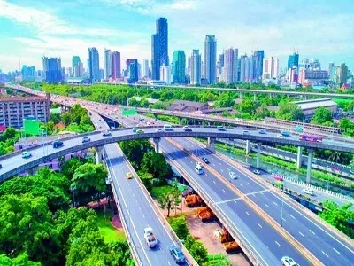
PM GatiShakti master plan tracks 396 projects worth ₹18.66 lakh crore
Synopsis
Five years after its October 2021 launch, PM GatiShakti is no longer just a planning tool — it is the nerve centre of India's infrastructure ambition. With ₹18.66 lakh crore worth of projects under its watch, 198 already in implementation, and 23,493 data layers on its GIS platform, the plan's true test is whether its coordination muscle can translate into on-time, on-budget delivery at the ground level.
Key Takeaways
396 major infrastructure projects worth ₹18.66 lakh crore are being tracked under the PM GatiShakti National Master Plan as of 11 August 2026 .
256 projects have been sanctioned; 198 are currently under implementation.
The GIS-based platform hosts 23,493 data layers and provides access to 230 approved datasets .
The plan covers 58 Central Ministries and Departments and all 36 states and Union Territories .
Seven infrastructure engines — roads, railways, ports, waterways, airports, mass transport, and logistics — anchor the plan's sectoral scope.
The Khagaria–Purnea corridor in Bihar exemplifies the plan's integrated approach, linking five economic nodes and 11 logistics nodes .
As many as 396 major infrastructure projects with a combined investment of ₹18.66 lakh crore are being tracked under the PM GatiShakti National Master Plan (NMP), according to a government factsheet released on Monday, 12 October 2026. The data, current as of 11 August 2026, underscores the scale at which India is coordinating multimodal infrastructure development through a single digital planning framework.
Project Status at a Glance
Of the 396 projects under the plan, 256 have been sanctioned, and 198 of those are currently under implementation. The institutional framework is backed by a digital platform that equips planners with geospatial data, satellite imagery, and advanced analytical tools. The platform also hosts 23,493 data layers as of 12 October 2026, drawing infrastructure and contextual information onto a single GIS-based interface.
The PM GatiShakti Public Platform provides access to 230 approved datasets, enabling site suitability analysis, connectivity mapping, alignment planning, and regulatory compliance checks across sectors.
What the Plan Maps and Why It Matters
The NMP integrates economic, social, and logistics nodes with multimodal connectivity infrastructure — bringing development context directly into the planning process. Economic zones such as textile clusters, pharmaceutical parks, defence corridors, electronic parks, industrial corridors, fishing clusters, and agri zones are all mapped to support coordinated infrastructure planning.
A concrete example is the Khagaria–Purnea corridor in Bihar, where the upgraded route is planned to connect five PM GatiShakti Economic Nodes — including a textile cluster, mega food parks, and fishing and seafood parks — along with 11 logistics nodes. The planned connectivity aims to accelerate the movement of both goods and passengers across the region.
This comes amid India's broader infrastructure push, where roads, railways, ports, airports, waterways, and utilities frequently converge within the same geographic zones. Planning these networks in isolation has historically led to cost overruns, duplication, and missed linkages. The GatiShakti framework attempts to address precisely that.
Six Principles, Seven Engines
PM GatiShakti is guided by six core principles: integrated development, multimodal infrastructure, last-mile connectivity, expedited land acquisition, minimised clearances, and reduced ecological impact. The plan's seven infrastructure engines — roads, railways, ports, waterways, airports, mass transport, and logistics infrastructure — form the backbone of its sectoral coverage.
The plan spans 58 Central Ministries and Departments and all 36 states and Union Territories, making it one of the most comprehensive spatial planning frameworks in India's administrative history.
Five Years On: The Platform's Growth
Launched on 13 October 2021, the PM GatiShakti NMP brought data from multiple ministries, states, and Union Territories onto a common Geographic Information System (GIS)-based platform for the first time. Five years on, the framework has evolved from a coordination tool into a nationwide planning standard, with its data layers and approved datasets growing substantially since inception.
Notably, this is one of the few infrastructure planning initiatives in India to explicitly incorporate missing connectivity gap analysis — identifying where the absence of a link could disrupt the seamless movement of people, goods, and services. As the plan approaches the halfway mark of its implementation cycle, the focus will increasingly shift from project sanctioning to on-ground delivery.
Point of View
396 projects, 23,493 data layers — but the headline numbers obscure a quieter question: are sanctioned projects translating into completed assets on time? With 256 projects sanctioned but only 198 under active implementation, the gap between green-lit and genuinely moving is worth scrutiny. India has a long history of infrastructure initiatives that were strong on vision and weak on last-mile execution. The real value of GatiShakti will be measured not by how many projects it tracks, but by how many it helps finish faster and cheaper than the pre-GatiShakti baseline.
NationPress
12 Oct 2026
Frequently Asked Questions
What is the PM GatiShakti National Master Plan?
The PM GatiShakti National Master Plan is a GIS-based digital infrastructure planning framework launched on 13 October 2021. It integrates data from 58 Central Ministries and Departments and all 36 states and Union Territories to enable coordinated, multimodal infrastructure planning across India.
How many projects are currently under PM GatiShakti, and what is their total value?
As of 11 August 2026, a total of 396 large-scale infrastructure projects worth ₹18.66 lakh crore are being tracked under the plan. Of these, 256 have been sanctioned and 198 are currently under implementation.
Which sectors are covered under the PM GatiShakti plan?
The plan's seven infrastructure engines cover roads, railways, ports, waterways, airports, mass transport, and logistics infrastructure. Economic zones including textile clusters, pharmaceutical parks, defence corridors, electronic parks, and agri zones are also mapped on the platform.
What is the PM GatiShakti digital platform and what does it offer?
The PM GatiShakti Public Platform is a GIS-based tool that hosts 23,493 data layers and 230 approved datasets as of October 2026. It enables site suitability analysis, connectivity mapping, alignment planning, and compliance checks, giving planners geospatial data and satellite imagery in a single interface.
How does the Khagaria–Purnea corridor illustrate the GatiShakti approach?
The Khagaria–Purnea corridor in Bihar is planned to connect five PM GatiShakti Economic Nodes — including a textile cluster, mega food parks, and fishing and seafood parks — along with 11 logistics nodes. It is a model case of the plan's integrated approach to linking economic zones with multimodal transport networks.