Kolkata Experiences a 6°C Drop in Temperature After Overnight Rain

Synopsis
Kolkata faced a dramatic drop in temperature following overnight rain, with a decrease of 6 degrees Celsius reported. The Met department anticipates ongoing rainfall and turbulent weather conditions across the region, including warnings for heavy rainfall in northern Bengal.
Key Takeaways
The temperature in Kolkata fell by 6 degrees Celsius due to overnight rain.
The Met department predicts ongoing scattered rain throughout the day.
A heavy rainfall warning is in effect for northern Bengal.
Wind speeds could reach up to 70 kilometers per hour in certain districts.
Fishermen are advised against venturing into the sea until conditions improve.
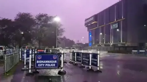
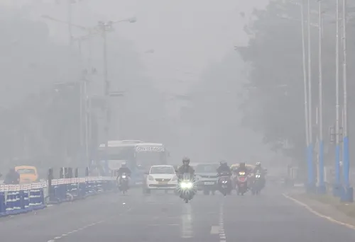
Kolkata, March 21 (NationPress) In the aftermath of overnight rain, the minimum temperature in Kolkata experienced a significant drop of 6 degrees Celsius on Saturday. The Meteorological Department predicts that scattered to moderate rain will persist throughout the day.
The Regional Meteorological Centre, located in Alipore, Kolkata, indicates that this weather pattern is expected to remain in place for several more days, affecting Kolkata and various districts in south Bengal.
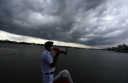
Additionally, a warnings for heavy to very heavy rainfall has been issued for the northern regions of Bengal, with the Bay of Bengal also anticipated to remain turbulent for the next two days.
Since Friday evening, Kolkata has been lashed by rain, thunderstorms, and squally winds reaching speeds of 50 to 60 kilometers per hour. The intensity of the rainfall increased overnight, leading to severe downpours in multiple areas of Kolkata, along with lightning and strong winds.
The temperature in Kolkata has dipped sharply by 6 degrees Celsius due to the rain. It was recorded at 25 degrees Celsius on Friday morning, but plummeted to 19.2 degrees Celsius on Saturday morning, which is 4.4 degrees below the seasonal average.
The Meteorological Department forecasts a potential rise in temperature by three to five degrees after two days of falling temperatures.
Beyond Kolkata, several districts in South Bengal also faced storms and rainfall on Saturday night. In the Malda district, the roof of a wholesale market at the Netaji Municipal Market in English Bazar collapsed due to the storm, resulting in injuries to two individuals.
North Bengal is also experiencing adverse weather conditions. The Meteorological Department has issued a heavy rainfall alert for the districts of Darjeeling, Kalimpong, Jalpaiguri, Alipurduar, and Cooch Behar. Storms and rain are expected to persist across north Bengal until next Wednesday or Thursday.
A warning remains active for Kolkata on Saturday, predicting scattered rainfall accompanied by gusty winds of 50 to 60 kilometers per hour.
In districts such as Howrah, Hooghly, Bankura, Murshidabad, Nadia, and East Burdwan, wind speeds could escalate to 60 to 70 kilometers per hour.
The severity of the adverse weather is anticipated to diminish somewhat starting Sunday evening, with warnings primarily focused on the districts of South 24 Parganas, East Midnapore, West Midnapore, and Jhargram.
Due to the ongoing cyclonic circulation, the Met Office has advised fishermen to refrain from venturing into the sea until Sunday, as turbulent waters are expected in the Bay of Bengal adjacent to Odisha.
The Meteorological Department reports a cyclonic circulation over northwest Madhya Pradesh and adjacent southern Uttar Pradesh, extending into a surface trough across Madhya Pradesh and Uttar Pradesh to Nagaland. This trough extends over Jharkhand, Gangetic West Bengal, and South Assam, positioned at an altitude of 0.9 kilometers above sea level. This system is facilitating a significant influx of moisture from the Bay of Bengal, resulting in favorable conditions for continued rainfall throughout the state.
Point of View
The drastic weather changes in Kolkata highlight the impact of seasonal fluctuations. The authorities' proactive measures in issuing warnings reflect a commitment to public safety amidst the challenges posed by unpredictable weather patterns.
NationPress
23 Jun 2026
Frequently Asked Questions
What caused the temperature drop in Kolkata?
The temperature in Kolkata dropped due to overnight rain accompanied by thunderstorms, causing a significant decrease in the minimum temperature.
How long is the rain expected to continue?
The Met department forecasts that scattered to moderate rain will continue throughout the day and possibly for several more days.
Are there any warnings for heavy rainfall?
Yes, a warning for heavy to very heavy rainfall has been issued for the north Bengal region.
What are the expected wind speeds during this weather?
Wind speeds are anticipated to reach 50 to 60 kilometers per hour, with some districts possibly experiencing speeds up to 70 kilometers per hour.
Is it safe for fishermen to go to sea?
No, the Met Office has advised fishermen to stay out of the sea until Sunday due to turbulent conditions in the Bay of Bengal.