What happened after a 6.3-magnitude earthquake hit Afghanistan?
Synopsis
A 6.3-magnitude earthquake has wreaked havoc in northern Afghanistan, claiming at least eight lives and injuring nearly 200. As rescue teams assess the damage, the true toll may yet rise. Discover the impact of this disaster on a region already grappling with humanitarian challenges.
Key Takeaways
At least eight fatalities reported from the earthquake.
Nearly 200 injuries recorded, with many requiring medical attention.
Rescue operations are ongoing to assess damage in remote areas.
The earthquake struck near Mazar-e Sharif at a depth of 28 km .
Afghanistan's geographical location makes it prone to seismic activity.
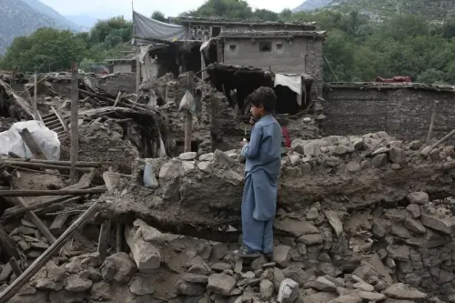
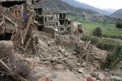
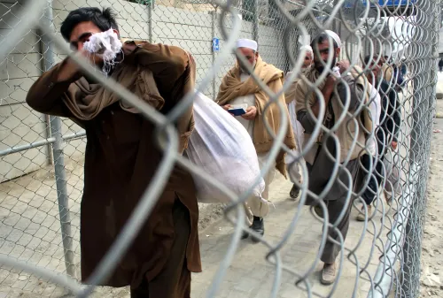
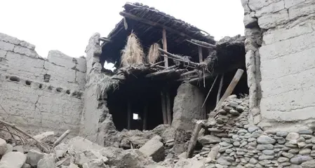
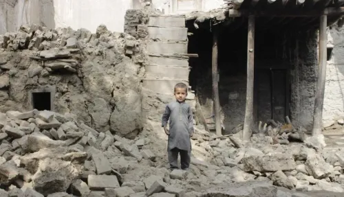
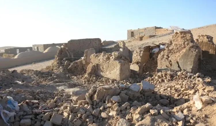
Kabul, Nov 3 (NationPress) At least eight individuals lost their lives and close to 200 others sustained injuries after a powerful 6.3-magnitude earthquake hit northern Afghanistan in the early hours of Monday, according to local media reports from Afghan government officials.
Qari Lutfullah Habibi, who heads the Public Health Department in Samangan province, reported that in the provincial capital, Aybak, one death occurred alongside more than 100 injuries. In the Hazrat Sultan district of Samangan, one fatality and 15 injuries were recorded. Additionally, in the bordering Balkh province, six deaths and over 70 injuries were reported in the Khulm district.
The Afghan government has indicated that rescue operations are underway to evaluate damage in remote regions affected by the earthquake, cautioning that the number of casualties may increase as communication systems are restored. Medical and emergency personnel have been deployed to the impacted areas, where local hospitals are struggling to manage the rising influx of injured individuals, as reported by Xinhua news agency.
Due to its mountainous terrain and inadequate infrastructure, Afghanistan is frequently subjected to devastating earthquakes that result in substantial casualties. The nation is grappling with a persistent humanitarian crisis, severely hampering its capacity to respond to such disasters effectively. Geographically, Afghanistan is situated in a collision zone between the Eurasian and Indian tectonic plates, with additional seismic influence from the Arabian plate to the south, making it one of the most seismically active regions globally.
The US Geological Survey (USGS) issued an orange alert through its PAGER system—an automated tool that evaluates potential earthquake impacts—warning that “significant casualties are likely and the disaster could be widespread.”
The tremor struck at a depth of 28 km (17.4 miles) near Mazar-e Sharif, a city with a population of approximately 523,000, as reported by the USGS.
Videos depicting rescue efforts to save trapped individuals alongside images of collapsed structures and scattered debris have gone viral on the social media platform X.
Previously, on September 23, a 4.9-magnitude earthquake shook southeastern Afghanistan, as noted by the GFZ German Research Centre for Geosciences. The epicenter was identified at a shallow depth of 10 km, with coordinates at 34.48 degrees north latitude and 70.71 degrees east longitude.
Since the Taliban assumed power in 2021, the government has dealt with multiple devastating earthquakes, including one in 2023 in the western Herat region near the Iranian border, which claimed over 1,500 lives and destroyed more than 63,000 homes.
Seismologist Brian Baptie from the British Geological Survey stated that northeastern Afghanistan has experienced 12 earthquakes with a magnitude exceeding 7 since 1900. Further research indicates that more than 355 earthquakes surpassing a magnitude of 5.0 have occurred across the nation since 1990.
Point of View
It is imperative for the Afghan government and international community to prioritize disaster preparedness and response. With the ongoing humanitarian crisis, the need for a robust infrastructure and emergency response systems becomes even more critical. The safety and well-being of the Afghan people must come first in these challenging times.
NationPress
20 Jun 2026
Frequently Asked Questions
What was the magnitude of the earthquake in Afghanistan?
The earthquake that struck northern Afghanistan had a magnitude of 6.3.
How many casualties were reported from the earthquake?
At least eight people were killed, and nearly 200 others were injured.
What areas were most affected by the earthquake?
The provincial capital Aybak in Samangan and the Khulm district in Balkh province were among the hardest hit.
What challenges does Afghanistan face in responding to disasters?
Afghanistan struggles with weak infrastructure and ongoing humanitarian crises, which hinder effective disaster response.
What is the seismic activity like in Afghanistan?
Afghanistan is situated in a seismically active region, experiencing numerous earthquakes due to its position along major tectonic plates.