CM Himanta Issues Assam Floods Update for July 22
Synopsis
Assam Chief Minister Himanta Biswa Sarma posted a flood situation update on July 23, 2026, covering conditions as of July 22, sharing images of the ongoing monsoon crisis that annually batters the Brahmaputra valley and displaces thousands of residents.
Key Takeaways
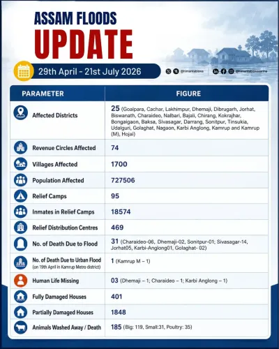
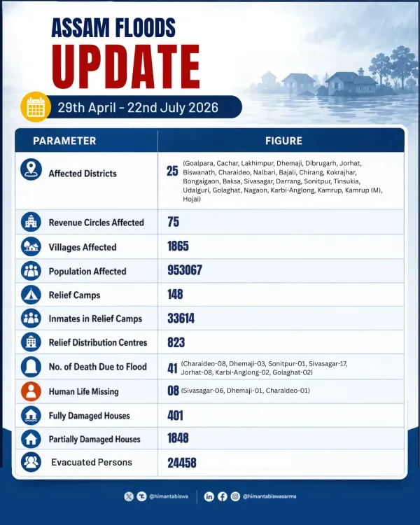
CM Himanta Biswa Sarma issued a public flood update on July 23, 2026 , covering the situation as of July 22, 2026 .
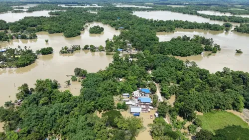
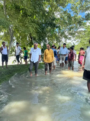
The post included two images documenting flood conditions or relief operations in Assam .
Assam faces recurrent monsoon flooding driven by the Brahmaputra river and its tributaries every June-September season.
The Brahmaputra Board , established in 1980 , is the nodal body for flood control coordination in the valley.
Key stakeholders include agricultural communities , displaced residents in relief camps, and wildlife in areas such as Kaziranga National Park .
Further state government announcements on districts affected, relief camps, and central assistance requests are expected as the season continues.
Assam Chief Minister Himanta Biswa Sarma on Thursday, July 23, 2026, shared a fresh situational update on the ongoing flood crisis across Assam, flagging conditions as recorded on July 22, 2026. The post, accompanied by two images, forms part of the state government's active disaster communication during the peak monsoon season.
Context
Assam is one of India's most flood-prone states, battered every monsoon by the Brahmaputra river and its network of tributaries. The June-to-September flood season routinely inundates agricultural land, displaces communities, and damages road and embankment infrastructure across multiple districts. Chief Minister Himanta Biswa Sarma has maintained a practice of issuing periodic public updates during active flood events, keeping citizens and relief agencies informed of ground conditions.
The July 22 update arrives at a critical phase of the 2026 monsoon season, when river levels across the Brahmaputra valley typically approach or breach danger marks. The two images shared alongside the post are expected to illustrate the extent of inundation or relief operations underway at the time of reporting.
Policy Backdrop
Flood management in Assam operates within a framework that includes the Brahmaputra Board, established in 1980, which coordinates flood control and river management across the Brahmaputra valley. Successive state governments have pursued embankment strengthening, dredging initiatives, and centralised relief distribution to mitigate annual flood damage.
Under current arrangements, the state government coordinates with the National Disaster Response Force (NDRF) and the State Disaster Response Force (SDRF) to run relief camps, rescue stranded residents, and restore essential services. Central assistance through the National Disaster Response Fund (NDRF) supplements state resources when losses cross prescribed thresholds.
Stakeholders and Impact
The communities most directly affected by Assam's annual floods are agricultural households in low-lying districts along the Brahmaputra and its tributaries, where crop loss and livestock deaths compound economic hardship. Embankment breaches can cut off entire villages, forcing residents into relief camps for weeks at a stretch.
Beyond rural communities, urban settlements in districts such as Kamrup, Barpeta, Morigaon, and Nagaon also face periodic inundation, disrupting livelihoods and public health infrastructure. Wildlife in Kaziranga National Park, a UNESCO World Heritage Site, faces heightened risk during severe flood years as animals move onto highway corridors to escape rising waters.
What's Next
Observers will watch for follow-up announcements from the state government on the number of districts affected, persons displaced, and relief camps operational as the monsoon season progresses through August 2026. Any request for enhanced central assistance or deployment of additional NDRF teams will signal the severity of the current flood cycle.
The remainder of the monsoon season is also likely to bring scrutiny of embankment repair tenders and the pace of dredging work on key tributaries — long-standing structural responses to a problem that costs Assam billions of rupees in annual damages and remains one of the state's most persistent governance challenges.
Point of View
Where the chief executive's public feed doubles as an official situation report. For Assam, where flood mismanagement has historically been a political flashpoint, these updates serve both an administrative and a reputational function — demonstrating executive engagement during a crisis. The structural challenge, however, remains unchanged: annual updates signal responsiveness, but the Brahmaputra valley's flood burden will not ease without long-term investments in embankment integrity and river management that successive governments have promised but only partially delivered. How the state translates this season's damage data into actionable infrastructure commitments will be the more consequential story to watch.
NationPress
22 Oct 2026
Frequently Asked Questions
What is the latest update on Assam floods in July 2026?
Assam Chief Minister Himanta Biswa Sarma shared a situational update on July 23, 2026, covering flood conditions as of July 22, 2026, along with two images documenting the ongoing crisis.
Why does Assam flood every year?
Assam floods annually because the Brahmaputra river and its numerous tributaries swell during the June-to-September monsoon season, regularly breaching embankments and inundating low-lying agricultural and residential areas.
What is the Brahmaputra Board and what does it do?
The Brahmaputra Board is a statutory body established in 1980 to coordinate flood control, drainage, and river management across the Brahmaputra valley in northeastern India.
How does the Assam government respond to floods?
The Assam state government deploys NDRF and SDRF teams for rescue operations, runs relief camps for displaced persons, and coordinates with the central government for financial assistance through the National Disaster Response Fund.
Which districts in Assam are most affected by floods?
Districts such as Kamrup, Barpeta, Morigaon, and Nagaon are among the most frequently inundated, along with areas adjoining Kaziranga National Park where wildlife is also at risk during severe flood years.