Has Cyclone Ditwah Weakened, Easing Rainfall Threat for Northern TN?
Synopsis
Cyclone Ditwah has transformed into a deep depression, bringing a sigh of relief to northern Tamil Nadu as heavy rainfall warnings ease. With the cyclone moving parallel to the coast, the meteorological outlook suggests a significant reduction in rainfall threats, making way for a more stable weather pattern.
Key Takeaways
Cyclone Ditwah has weakened significantly.
Heavy rainfall threats for northern Tamil Nadu are easing.
Regions like Karaikal and Sembanarkovil have recorded notable rainfall.
Light to moderate rainfall is predicted to continue.
Fishermen should avoid venturing into rough seas.
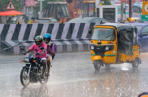
Chennai, Dec 1 (NationPress) Cyclone Ditwah, which emerged over the Southwest Bay of Bengal, has notably diminished into a deep depression, providing relief to the northern districts of Tamil Nadu that were previously alerted to the risk of extremely heavy rainfall.
The Regional Meteorological Centre (RMC) reported that the weather system lost its intensity while moving parallel to the Tamil Nadu-Puducherry coastline. As per the latest 24-hour rainfall statistics recorded on Sunday morning, Karaikal experienced the highest precipitation at 19 cm, closely followed by Sembanarkovil in the Mayiladuthurai district with 17 cm.
Nagapattinam and Mayiladuthurai towns each recorded 15 cm, while Sirkazhi and Tiruvarur regions received 14 cm. Additionally, in the Ramanathapuram district, Thangachimadam and Thondi reported substantial rainfall. Other areas in the delta, such as Tirupoondi in Nagapattinam and Kurungulam in Thanjavur, also noted 13 cm of rain.
Kodiyakarai and Vedaranyam (in Nagapattinam district), along with Nannilam (in Tiruvarur district) and Sethiyathoppu (in Cuddalore district) recorded 12 cm each, indicating consistent rain across coastal areas.
The weakened system, which extended nearly 180 km while progressing northward over the Southwest Bay of Bengal, was located this morning approximately 110 km southeast of Puducherry, 140 km northeast of Vedaranyam, and 180 km south-southeast of Chennai.
Now classified as a deep depression, the cyclone continues to move parallel to the Tamil Nadu coast without making landfall. Meteorologists indicate that as the system further weakens, the distance between it and the Tamil Nadu coastline may decrease to about 30 km, and its reduced force signifies that the risk of widespread heavy rainfall has largely subsided.
The deep depression is anticipated to transition into a well-marked low-pressure area in the upcoming hours.
Looking ahead to Monday, the weather bureau has predicted light to moderate rainfall along with thunderstorms in various parts of Tamil Nadu and Puducherry. Isolated areas in the Tiruvallur district may still experience heavy showers.
Light to moderate rainfall is expected to continue over several regions until December 6. In Chennai and its surrounding areas, the sky is likely to remain predominantly cloudy, with a chance of moderate rain accompanied by thunder and lightning in some locations.
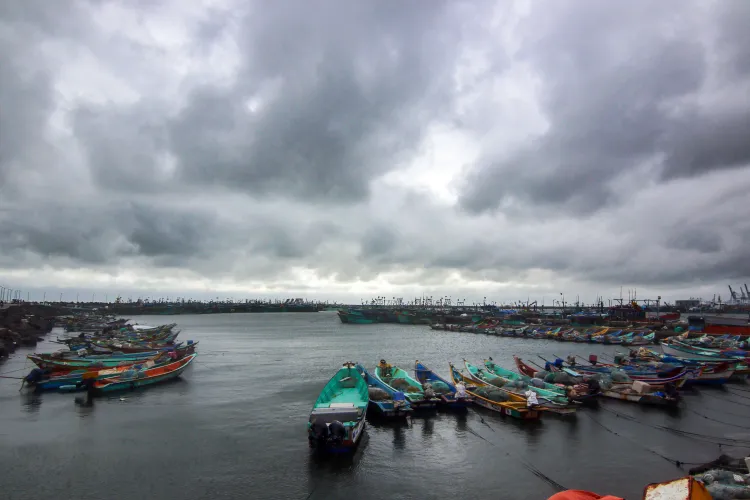
Additionally, strong winds are forecasted over the Gulf of Mannar, Kumari Sea, and parts of the Southwest Bay of Bengal. Fishermen are strongly advised against venturing into these waters due to rough sea conditions and gusty winds associated with the weakening system.
Point of View
My perspective emphasizes the resilience of communities in Tamil Nadu during weather adversities. Cyclone Ditwah's transition to a deep depression demonstrates the effectiveness of meteorological predictions and preparedness, ensuring that the people remain informed and safe.
NationPress
29 Jun 2026
Frequently Asked Questions
What is the current status of Cyclone Ditwah?
Cyclone Ditwah has weakened into a deep depression and is moving parallel to the Tamil Nadu coast, significantly reducing the threat of heavy rainfall.
How much rainfall has Tamil Nadu received?
Karaikal received the highest rainfall of 19 cm, followed by Sembanarkovil with 17 cm, with other regions experiencing substantial rainfall as well.
What can we expect in the coming days?
Light to moderate rainfall with possible thunderstorms is forecasted for various parts of Tamil Nadu and Puducherry until December 6.
Are there any warnings for fishermen?
Yes, fishermen are advised not to venture into the Gulf of Mannar and nearby seas due to rough conditions associated with the weakening system.
Will the rainfall continue in Chennai?
Chennai can expect generally cloudy skies with possible moderate rain and thunderstorms at some locations.