Are Official Figures Ignoring 90% of Farm Fires in Haryana and Punjab? Report Highlights Need for Focus on UP and MP Hotspots

Synopsis
A recent report reveals shocking gaps in the monitoring of farm fires in Punjab and Haryana, indicating that over 90% of these incidents are missed. As farmers adjust their burning schedules, attention needs to shift to emerging hotspots in UP and MP. The findings urge a total overhaul of stubble burning monitoring protocols in India.
Key Takeaways
90% of large farm fires in Punjab and Haryana are missed due to monitoring system limitations.
Farmers have shifted burning times to after 3 pm . iFOREST's report highlights the need for updated monitoring protocols.
Burnt-area analysis shows significant progress in reducing stubble burning.
Immediate reforms are critical to accurately measure and manage air quality impacts.
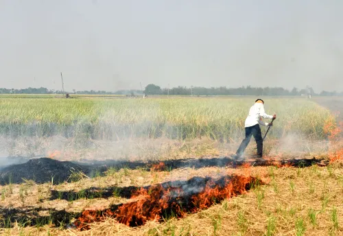
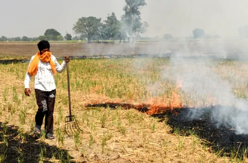
Chandigarh, Dec 8 (NationPress) A recent report has indicated that official statistics overlook over 90% of significant farm fires in Haryana and Punjab due to altered burning schedules by farmers, revealing a significant gap in India's strategy to tackle stubble burning. The report emphasizes the urgency to shift attention toward rising biomass burning hotspots in Uttar Pradesh (UP) and Madhya Pradesh (MP).
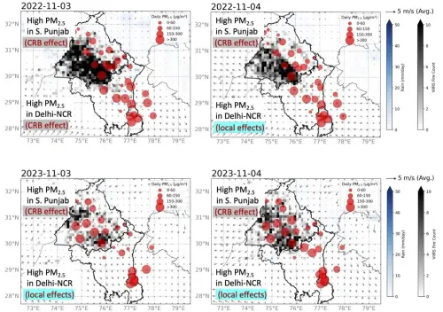
The Stubble Burning Status Report -- 2025 from the International Forum for Environment, Sustainability and Technology (iFOREST) highlights that while government reports claim a dramatic 90% decline in farm fires in Punjab and Haryana, this apparent reduction is mainly due to the inadequacies of the current monitoring system operated by the Consortium for Research on Agroecosystem Monitoring and Modeling from Space (CREAMS) at the Indian Agricultural Research Institute (IARI).
The report unveils India's inaugural multi-satellite, multi-sensor evaluation, integrating MODIS (from Terra and Aqua satellites), VIIRS (from the Suomi-NPP satellite), Sentinel-2 Multispectral Instrument (MSI) for burnt-area mapping, and 15-minute geostationary observations from the Spinning Enhanced Visible and Infrared Imager (SEVIRI) on Meteosat 8 and 9.
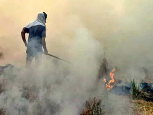
Findings illustrate that the CREAMS monitoring framework, primarily reliant on polar-orbiting satellites (MODIS/VIIRS) that pass over India from 10:30 am to 1:30 pm, miss the majority of large farm fires, which are now occurring later in the afternoon and evening.
Through SEVIRI’s high-frequency insights, the report reveals that in Punjab, over 90% of significant fires in 2024 and 2025 took place after 3 pm, a stark contrast to just 3% in 2021.
In Haryana, most large fires have been reported after 3 pm since 2019, indicating a persistent issue of underreporting.
The report cautions that such data deficiencies are undermining the evidence foundation for policies relating to air quality.
Chandra Bhushan, CEO of iFOREST, stated, “Our analysis provides undeniable proof that India’s existing stubble-burning monitoring framework is fundamentally misaligned with on-ground realities.
“Farmers have altered burning times to late afternoons, while our monitoring depends on satellites capturing active fires within a restricted time frame of 10:30 am to 1:30 pm.
The outcome is a significant underestimation of fires, emissions, and their impact on air pollution in Delhi. We must urgently reform the system.”
Simultaneously, iFOREST's burnt-area analysis indicates real progress in diminishing stubble burning in Punjab and Haryana.
Burnt-area mapping via the Sentinel-2 satellite shows that Punjab's burned area during the Kharif season has plummeted from a peak of 31,447 sq km in 2022 to around 20,000 sq km in 2025, marking a 37% reduction.
In Haryana, the burnt area decreased from a peak of 11,633 sq km in 2019 to 8,812 sq km in 2025, a 25% reduction, albeit without a consistent downward trend.
Commenting on these outcomes, Bhushan remarked, “Burnt area offers a more trustworthy depiction of stubble burning. Our analysis confirms that Punjab and Haryana have successfully reduced burnt areas by 25-35%, which is encouraging and signals that both in-situ and ex-situ stubble management practices are being embraced.
“However, this is not a time to become complacent. Even in 2025, nearly 30,000 sq km of paddy fields were burned in Punjab and Haryana, making them a significant factor in air quality deterioration in Delhi-NCR and the broader Indo-Gangetic region.”
The report urges immediate corrective actions, including updated monitoring methods. CREAMS should start publishing burnt-area data, not merely active fire counts, to create an accurate national overview. Additionally, the decision support system (DSS) utilized by the Indian Institute of Tropical Meteorology (IITM) for managing Delhi’s air quality must modify its methodology to accurately assess the impact of stubble burning.
Regarding future policies, Ishaan Kochhar, Programme Lead at iFOREST, mentioned, “We cannot manage what we do not measure correctly. Policy determinations are currently influenced by incomplete data. To effectively address the stubble-burning challenge in the Indo-Gangetic Plain, the government must promptly reform the monitoring protocols to incorporate burnt-area mapping and geostationary data. Furthermore, we must broaden our attention beyond Punjab and Haryana to emerging hotspots in Uttar Pradesh and Madhya Pradesh.
Point of View
It is essential to recognize that the report highlights significant deficiencies in the current monitoring system of stubble burning in India. Such gaps not only undermine efforts to improve air quality but also call for urgent reforms to ensure accurate data-driven policymaking. The focus must expand to emerging hotspots to tackle environmental challenges effectively.
NationPress
21 Jun 2026
Frequently Asked Questions
Why are farm fires significant?
Farm fires contribute to air pollution, affecting public health and the environment, particularly in densely populated regions like Delhi.
What is the role of iFOREST?
iFOREST is an organization that focuses on environmental sustainability and technology, providing critical analyses and reports on issues like stubble burning.
How can monitoring of farm fires be improved?
Improving monitoring requires integrating advanced satellite technologies and updating protocols to account for changing burning times.
What are the impacts of stubble burning on air quality?
Stubble burning releases pollutants that significantly degrade air quality, leading to health hazards and environmental degradation.
What steps can be taken to manage stubble burning?
Implementing in-situ and ex-situ stubble management practices, revising monitoring systems, and expanding focus to emerging hotspots can help manage stubble burning.