Nagaland University researchers use GIS to map soil erosion in Northeast hills
Synopsis
A Nagaland University study published in a Springer Nature journal has used satellite-based GIS modelling to pinpoint soil erosion hotspots across the Siji watershed in Assam — one of the Northeast's most at-risk zones. The research recommends an Integrated Watershed Management approach combining terracing, contouring, and vegetation cover, and offers a replicable framework for erosion-prone regions across India and beyond.
Key Takeaways
Nagaland University researchers published a GIS and RUSLE-based soil erosion study in a Springer Nature peer-reviewed journal on 6 May .
The study focuses on the Siji watershed in the Gai River Basin, Assam , one of the most erosion-prone areas in Northeast India.
Areas with dense forest cover showed minimal erosion; steep slopes, croplands, and mining zones face extremely high erosion risk.
Researchers recommend an Integrated Watershed Management (IWM) approach including contouring, terracing, and vegetation cover.
The framework is designed to be adaptable to other regions with similar conditions, both within India and globally.
Future work flagged includes flood prediction models and improved environmental monitoring systems for the region.
Researchers at Nagaland University have advocated a geospatial technology-driven approach to combat soil erosion across the hilly regions of Northeast India, the university announced on Wednesday, 6 May. Their study, published in a peer-reviewed Springer Nature journal, uses satellite-based modelling to identify erosion hotspots and recommend targeted conservation measures across the region's vulnerable watersheds.
The Erosion Crisis in the Eastern Himalayas
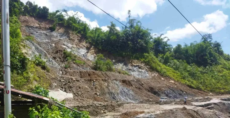
Soil erosion has emerged as a serious environmental and ecological threat across the eastern Himalayan region, degrading agricultural productivity, straining water resources, and disrupting ecological balance. The problem is compounded by steep slopes, high-intensity rainfall, deforestation, and unscientific land use — including shifting cultivation, mining, and rapid infrastructure development. Researchers warn that without structured intervention, land degradation will accelerate as climate pressures and human activity intensify.
What the Study Examined
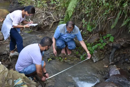
The research focuses on the Siji watershed, located within the Gai River Basin in Assam — one of the most erosion-prone sub-regions in the Northeast. Using the Revised Universal Soil Loss Equation (RUSLE) integrated with GIS-based modelling, the team assessed soil erosion and sediment transport by analysing rainfall intensity, soil characteristics, slope gradients, land use patterns, and conservation practices. The watershed-based approach enables micro-level identification of erosion hotspots, allowing planners to prioritise high-risk zones rather than applying uniform solutions.
The research paper was co-authored by Prof. M. S. Rawat, Department of Geography, School of Sciences, Nagaland University, alongside research scholar Tulumoni Gogoi and Dr Pradeep Kumar Rawat, Consultant Professor, Asian International University, Manipur.
Key Findings
The findings reveal that areas with dense forest cover and gentle slopes experience minimal erosion, while regions with steep slopes, croplands, barren land, and human disturbances — such as road construction and mining — face significantly higher risk. In some zones, erosion rates were found to be extremely high, posing serious threats to land stability and local ecosystems. The spatial data layers integrated into the model can also quantify soil loss across micro-level units within the watershed, making prioritisation of interventions far more precise.
What the Researchers Recommend
Elaborating on the study's proposed solutions, Prof. Rawat said: "We recommend an Integrated Watershed Management (IWM) approach. This includes developing sustainable land use plans and implementing mechanical and biological measures such as contouring, terracing, and vegetation cover to reduce soil loss and improve water management." The model is also designed to guide policymakers in making informed decisions on land use and conservation. The researchers note that the framework can be adapted for other regions with similar geographical and environmental conditions, both within India and globally.
Institutional Backing and the Road Ahead
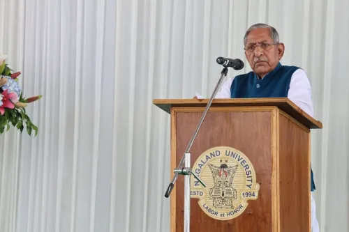
Nagaland University Vice Chancellor Prof. Jagadish K. Patnaik described the study as "a significant step towards addressing one of the most pressing environmental challenges in Northeast India." He said integrating geospatial technology can effectively guide conservation efforts, reduce soil degradation, and promote sustainable land use. The research also flags the need for future work, including flood prediction models and improved monitoring systems. Given the growing impact of climate-related factors and human activity, the team stressed that timely intervention is crucial to prevent further environmental degradation across the region.
Point of View
But the Nagaland University study deserves attention beyond academic circles. The Northeast's erosion crisis is not merely ecological — it directly undermines agricultural livelihoods and water security for millions in a region already stressed by climate variability and infrastructure expansion. The use of RUSLE-GIS integration to move from broad assessments to micro-level hotspot mapping is methodologically significant; it shifts the policy conversation from awareness to actionable prioritisation. The real challenge now is whether state governments and the Centre will use such frameworks to drive land-use policy, or whether this joins a growing library of well-researched studies that never reach the planning table.
NationPress
24 Jun 2026
Frequently Asked Questions
What did the Nagaland University soil erosion study find?
The study found that areas with dense forest cover and gentle slopes experience minimal erosion, while steep slopes, croplands, barren land, and zones affected by road construction and mining face extremely high erosion risk. It used RUSLE integrated with GIS modelling to map erosion hotspots across the Siji watershed in Assam.
What is the RUSLE method used in the study?
RUSLE stands for Revised Universal Soil Loss Equation, a scientific model that estimates soil erosion by analysing factors such as rainfall intensity, soil characteristics, slope, land use patterns, and conservation practices. When integrated with GIS, it allows researchers to map erosion risk at a micro-watershed level.
Which area did the Nagaland University study focus on?
The study focused on the Siji watershed, part of the Gai River Basin in Assam, identified as one of the most erosion-prone sub-regions in Northeast India.
What solutions do the researchers recommend to tackle soil erosion in Northeast India?
The researchers recommend an Integrated Watershed Management approach that includes developing sustainable land use plans and implementing mechanical and biological measures such as contouring, terracing, and increasing vegetation cover to reduce soil loss and improve water management.
Where was the Nagaland University soil erosion research published?
The research was published in a peer-reviewed journal under Springer Nature, which focuses on monitoring, assessment, and management of environmental quality. It was co-authored by Prof. M. S. Rawat, research scholar Tulumoni Gogoi, and Dr Pradeep Kumar Rawat of Asian International University, Manipur.