IMD warns of heavy rain in Assam for 5 more days from July 13

Synopsis
The IMD has put Assam on a five-day heavy-rain alert from 13 July, with intensity peaking mid-week as a monsoon trough and Bay of Bengal cyclonic circulations combine. Barpeta district already logged 15 cm in a single day — and the worst may not yet have arrived.
Key Takeaways
The IMD has forecast heavy to very heavy rainfall across Assam for five days starting 13 July .
The highest rainfall in the past 24 hours was 15 cm at Beki Road Bridge, Barpeta ; Pandu, Kamrup (Metro) recorded 14 cm .
Intensity is expected to peak on Tuesday and Wednesday , with heavy to very heavy rain at isolated locations.
Conditions are forecast to persist through 18 July with no significant change in maximum temperatures.
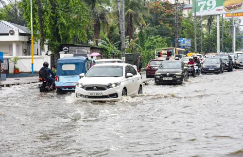
Risks include waterlogging, disruption to road, rail and ferry services, possible power outages, and damage to weak structures.
A monsoon trough extending from Sri Ganganagar to Manipur and upper-air circulations over the Bay of Bengal are driving the prolonged rainfall.
The India Meteorological Department (IMD) has forecast heavy to very heavy rainfall across Assam for five consecutive days starting 13 July, warning of thunderstorms and lightning at isolated locations even as the southwest monsoon remains vigorously active over the state. Officials issued the advisory on Monday, urging residents to stay alert.
Rainfall Recorded in the Past 24 Hours
According to the Regional Meteorological Centre (RMC), Guwahati, light to moderate rainfall occurred at most places across Assam during the previous 24 hours, with isolated heavy to very heavy showers in several districts. The highest single-station rainfall was recorded at Beki Road Bridge in Barpeta district at 15 cm, followed by Pandu in Kamrup (Metro) at 14 cm, Manas NH Crossing in Barpeta at 12 cm, and Dhupdhara in Goalpara at 11 cm. Barpeta town received 10 cm of rainfall.
What Is Driving the Weather System
The IMD noted that the monsoon trough currently stretches from Sri Ganganagar through northern India to Manipur. Upper-air cyclonic circulations over Bangladesh and the adjoining Bay of Bengal are amplifying moisture incursion into the Northeast, sustaining widespread rainfall activity across the region. This combination of a deep trough and offshore circulation is a classic driver of prolonged heavy-rain episodes in Assam during peak monsoon months.
Five-Day Forecast: Intensity to Peak Mid-Week
The weather office expects thunderstorms accompanied by lightning at isolated places on Monday. Intensity is set to rise sharply on Tuesday and Wednesday, with heavy to very heavy rainfall likely at isolated locations. Similar conditions are forecast to persist through 18 July, with moderate rainfall expected at many places and no significant change in maximum temperatures during this period.
Risks and Advisories for Residents
The IMD has cautioned that thunderstorms may uproot trees and damage vulnerable structures, while sustained heavy rain could trigger waterlogging in low-lying areas, disrupt road and rail traffic, affect ferry services, and cause temporary power outages. Residents have been advised to avoid sheltering under trees or weak structures during thunderstorms and to follow official weather advisories closely. This comes amid Assam's recurring vulnerability to monsoon-related flooding and landslides, which have historically displaced hundreds of thousands of people in the state each year.
Point of View
But the combination of a deep monsoon trough and active Bay of Bengal circulations raises the stakes. Assam's flood infrastructure remains chronically underprepared — drainage systems in low-lying districts like Barpeta and Goalpara are routinely overwhelmed even by moderate rainfall events. The IMD's advisory is timely, but the real test is whether district administrations translate a weather alert into pre-emptive evacuation and relief pre-positioning, rather than reactive response after damage is done.
NationPress
12 Oct 2026
Frequently Asked Questions
What has the IMD forecast for Assam from 13 July?
The IMD has forecast heavy to very heavy rainfall at isolated places across Assam for five days starting 13 July, accompanied by thunderstorms and lightning. Intensity is expected to peak on Tuesday and Wednesday before persisting at moderate levels through 18 July.
Which districts in Assam recorded the highest rainfall?
Barpeta district recorded the highest rainfall, with Beki Road Bridge logging 15 cm and Manas NH Crossing recording 12 cm. Pandu in Kamrup (Metro) received 14 cm, Dhupdhara in Goalpara received 11 cm, and Barpeta town received 10 cm in the past 24 hours.
What is causing the heavy rain in Assam?
The IMD attributes the prolonged rainfall to a monsoon trough extending from Sri Ganganagar through northern India to Manipur, reinforced by upper-air cyclonic circulations over Bangladesh and the Bay of Bengal. This system is sustaining widespread rainfall activity across the Northeast.
What are the risks associated with the forecast?
The IMD has warned of potential uprooting of trees, damage to vulnerable structures, waterlogging in low-lying areas, disruption to road, rail and ferry services, and temporary power outages. Residents are advised to avoid sheltering under trees or weak structures during thunderstorms.
When will the heavy rain in Assam subside?
According to the IMD forecast, conditions are expected to persist through 18 July, with moderate rainfall at many places. No significant change in maximum temperatures is anticipated during this period.