IMD yellow alert: 70 kmph winds, thunderstorms forecast for Rajasthan
Synopsis
The IMD has put Rajasthan on yellow alert as winds of up to 70 kmph and thunderstorms bear down on multiple districts. While eastern Rajasthan gets a rare cool break — with Srimadhopur recording 48 mm of rain — western districts like Phalodi are still baking at 44.8°C, painting a stark two-halves picture of the state's weather crisis.
Key Takeaways
IMD Jaipur issued a yellow alert on 4 May for thunderstorms and rain across several Rajasthan districts.
Strong winds of up to 70 kmph are expected during the alert period.
Highest rainfall in the last 24 hours: 48 mm at Srimadhopur .
Western Rajasthan continues to face intense heat — Phalodi recorded 44.8°C , the state's highest maximum temperature.
A fallen tree near Hawa Mahal, Jaipur and a blockage on the Jaipur-Agra National Highway caused localised traffic disruptions.
Weather is expected to remain unstable over the next few days, with intermittent rain and gusty winds forecast.
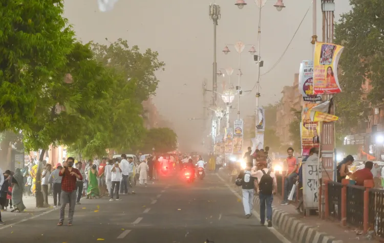
The India Meteorological Department's (IMD) Jaipur Meteorological Centre on Monday, 4 May issued a yellow alert for thunderstorms and rain across several districts of Rajasthan, warning of strong winds reaching up to 70 kmph. The alert follows a turbulent 24-hour period during which storms, rain, and gusty winds lashed multiple parts of the state.
Recent Weather Activity
In the preceding 24 hours, light to moderate rainfall accompanied by thunderstorms and squalls was recorded at isolated locations across Rajasthan. The highest rainfall during this period was logged at Srimadhopur at 48 mm. Districts including Sikar, Dausa, Kotputli-Behror, Alwar, and Hanumangarh witnessed heavy rain alongside thunderstorms and hailstorms on Sunday, with strong winds uprooting trees and damaging temporary structures in several areas.
Temperature Trends Across the State
Maximum temperatures have declined across most regions and are now hovering between 39 degrees Celsius and 41 degrees Celsius — below normal for this time of year. The sudden weather shift has pushed temperatures in most cities below 40 degrees Celsius, offering noticeable relief to residents. The lowest minimum temperature of 19.0 degrees Celsius was recorded in Alwar.
However, intense heat persisted in western Rajasthan. Phalodi recorded the highest maximum temperature at 44.8 degrees Celsius, followed by Jaisalmer at 42.8 degrees Celsius, Bikaner at 42.2 degrees Celsius, and Barmer at 41.7 degrees Celsius. Churu received 17.7 mm of rainfall, providing partial relief to the otherwise heat-struck western belt.
Ground-Level Disruptions
The extreme weather caused localised disruption across the state. In Manpur (Dausa district), intense rain and hailstorms lashed the area for nearly an hour, with a fallen tree near the Jaipur-Agra National Highway blocking traffic for approximately 40 minutes. In Jaipur, a tree fell near the iconic Hawa Mahal, temporarily disrupting traffic movement in the area.
Outlook for Coming Days
According to the IMD, weather conditions are expected to remain unstable over the next few days. Fluctuations in temperature will continue, with chances of light rainfall and gusty winds in several parts of the state, providing intermittent relief from the heat. Residents in affected districts have been advised to remain cautious during thunderstorm activity.
Point of View
A furnace in the west — is becoming an annual May pattern, yet state disaster preparedness remains reactive rather than anticipatory. The Hawa Mahal tree-fall and the Jaipur-Agra highway blockage are minor incidents today, but they underscore how urban infrastructure in Jaipur is ill-equipped for the increasingly intense pre-monsoon squalls that climate data suggests are growing stronger. The IMD yellow alert system works as a warning tool, but its value is only as good as the last-mile communication reaching rural households in vulnerable districts like Dausa and Hanumangarh.
NationPress
5 Jul 2026
Frequently Asked Questions
What is the IMD yellow alert issued for Rajasthan on 4 May?
The India Meteorological Department's Jaipur Meteorological Centre issued a yellow alert on 4 May warning of thunderstorms, rain, and strong winds reaching up to 70 kmph across several Rajasthan districts. A yellow alert advises residents to stay updated and take precautionary measures.
Which districts in Rajasthan were most affected by the storms?
Districts including Sikar, Dausa, Kotputli-Behror, Alwar, and Hanumangarh witnessed heavy rain, thunderstorms, and hailstorms. Strong winds uprooted trees and damaged temporary structures in several of these areas.
What was the highest rainfall recorded in Rajasthan in the last 24 hours?
The highest rainfall in the 24-hour period was recorded at Srimadhopur at 48 mm. Churu in western Rajasthan also received 17.7 mm, providing partial relief from the heat.
Why is western Rajasthan still experiencing extreme heat despite the storms?
Western districts like Phalodi, Jaisalmer, Bikaner, and Barmer received little to no rainfall, leaving them exposed to intense heat. Phalodi recorded the highest maximum temperature in the state at 44.8 degrees Celsius.
What disruptions did the storms cause in Jaipur?
In Jaipur, a tree fell near the iconic Hawa Mahal, disrupting traffic movement. In Manpur in Dausa district, a fallen tree near the Jaipur-Agra National Highway blocked traffic for approximately 40 minutes during heavy rain and hailstorms.