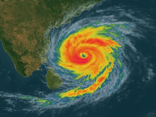
Bay of Bengal cyclonic storm likely by Oct 26, Andhra Pradesh and Odisha on alert

Synopsis
A low-pressure system over the Bay of Bengal is on course to become a cyclonic storm by 26 October, with North Andhra Pradesh and South Odisha in its projected path. With fishermen warned back to shore and rainfall alerts already active across Rayalaseema, the next 48 hours will be critical as the system intensifies rapidly through successive stages.
Key Takeaways
A low-pressure area has formed over the east-central and southeastern Bay of Bengal as of 23 October .
It is expected to intensify into a cyclonic storm over the west-central Bay of Bengal by 26 October morning , according to APSDMA and IMD .
The storm is projected to move towards North Andhra Pradesh and South Odisha coasts within two days of forming.
Gusty winds of 60–70 kmph are expected along the coast; widespread rainfall anticipated from 26 October .
Fishermen at sea have been urged to return to shore immediately ; farmers and coastal residents advised to take precautionary measures.
A low-pressure area has formed over the east-central and southeastern Bay of Bengal, and is expected to intensify into a cyclonic storm by 26 October, the India Meteorological Department (IMD) and the Andhra Pradesh State Disaster Management Authority (APSDMA) warned on Friday, 23 October. The development has prompted advisories for fishermen, farmers, and coastal residents across Andhra Pradesh and Odisha.
Intensification Timeline
According to APSDMA, the system is expected to deepen into a depression over the same region by 24 October, and further into a deep depression by 25 October. Prakhar Jain, Managing Director of the State Disaster Management Authority, stated that by the morning of 26 October, it is likely to strengthen into a cyclonic storm over the west-central Bay of Bengal.
The IMD corroborated this trajectory, noting that the system originated from an upper-air cyclonic circulation over the Southeast and adjoining East-Central Bay of Bengal on Thursday. It is most likely to move west-northwestwards, intensifying progressively over the coming days.
Projected Path and Coastal Impact
Over the two days following 26 October, the system is projected to track towards the coast of North Andhra Pradesh and adjoining South Odisha. Widespread rainfall is anticipated across Andhra Pradesh under the storm's influence, with heavy rainfall likely in isolated areas. Strong gusty winds reaching 60–70 kmph are expected along the coast.
This comes at a time when the Rayalaseema region of Andhra Pradesh is already experiencing scattered heavy rains due to a separate low-pressure influence over Tamil Nadu and Kerala. Light to moderate rainfall with lightning is expected on 24 and 25 October before the more widespread precipitation begins from 26 October onward.
Warnings Issued for Fishermen and Farmers
Authorities have urged fishermen currently at sea to return to shore immediately. The general public and the farming community have been advised to take precautionary measures ahead of the storm's anticipated landfall window. Officials have not yet specified a precise landfall location, as the system's exact track will depend on its intensification rate over the next 48–72 hours.
What to Watch Next
Disaster management agencies in both Andhra Pradesh and Odisha are expected to heighten preparedness protocols as the system strengthens. The IMD is likely to issue updated bulletins through the weekend. The storm's eventual landfall intensity and precise coastal strike point remain critical variables to monitor, with the next 24 hours considered decisive for the system's trajectory.
Point of View
And while disaster management infrastructure has improved, fishing communities and agricultural holdings in low-lying coastal belts remain acutely vulnerable. The absence of a confirmed landfall point this early is standard, but authorities issuing fishermen advisories three days out signals genuine concern about the system's strength. The real test will be the overnight bulletins of 24–25 October, when track models typically converge.
NationPress
23 Oct 2026
Frequently Asked Questions
What is the current status of the Bay of Bengal low-pressure area?
As of 23 October, a low-pressure area has formed over the east-central and southeastern Bay of Bengal. It is expected to intensify into a depression by 24 October, a deep depression by 25 October, and a cyclonic storm by 26 October morning, according to IMD and APSDMA.
Which states are likely to be affected by the cyclone?
North Andhra Pradesh and South Odisha are in the storm's projected path. Widespread rainfall, gusty coastal winds of 60–70 kmph, and heavy isolated rainfall are expected across Andhra Pradesh from 26 October onward.
What precautions have been advised for fishermen?
Fishermen currently at sea have been urged by APSDMA to return to shore immediately. The advisory was issued on 23 October given the rapid intensification expected over the coming days.
When is the cyclone expected to make landfall?
Authorities have not yet confirmed a precise landfall location or time. The system is projected to move towards the North Andhra Pradesh and South Odisha coasts during the two days following 26 October, making the landfall window approximately 27–28 October, subject to IMD updates.
What weather is Andhra Pradesh experiencing ahead of the cyclone?
Even before the cyclonic storm forms, Andhra Pradesh's Rayalaseema region is seeing scattered heavy rains due to a separate low-pressure influence over Tamil Nadu and Kerala. Light to moderate rainfall with lightning is forecast for 24 and 25 October across the state.