Indonesia earthquake: 6.7-magnitude quake in Central Sulawesi kills 3, injures 108

Synopsis
A 6.7-magnitude earthquake has struck Central Sulawesi — one of Indonesia's most seismically active zones — killing three, injuring over 100, and displacing thousands. With 13 aftershocks recorded and emergency status in force until 23 June, the disaster lands as Indonesia was already on tsunami alert from a 7.8-magnitude Philippines quake earlier this month.
Key Takeaways
A 6.7-magnitude earthquake struck Central Sulawesi, Indonesia on 17 June at 11:27 am local time , with its epicentre 42 km southeast of Palu City .
The death toll has risen to three , with 17 seriously injured and 91 with minor injuries — 108 total casualties .
6,412 people across 2,012 households have been affected; Sigi regency is the worst-hit area.
The provincial government declared a disaster emergency status effective until 23 June .
At least 13 aftershocks have been recorded; residents are warned to avoid damaged buildings.
The quake did not trigger a tsunami, but the region was already on alert following a 7.8-magnitude Philippines earthquake on 8 June .
A 6.7-magnitude earthquake that struck Central Sulawesi province in Indonesia on Tuesday, 17 June has killed three people and left 17 others seriously injured, the country's National Disaster Management Agency (BNPB) confirmed on Thursday. A further 91 people sustained minor injuries, while 6,412 residents have been affected by the disaster, according to the agency.
Key Developments
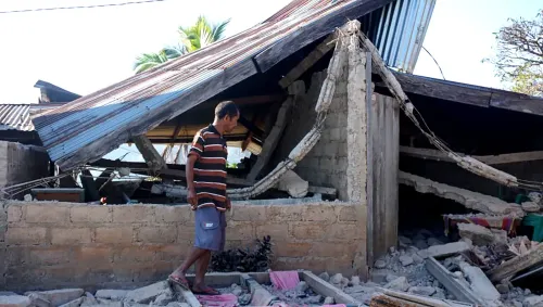
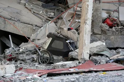
The tectonic earthquake struck at 11:27 am local time, with its epicentre located on land approximately 42 km southeast of Palu City at a shallow depth of 10 km. Authorities confirmed the quake did not trigger a tsunami. Sigi regency emerged as the worst-hit area, with damage reported across several villages. The disaster affected 2,012 households, predominantly in Sigi.
At least 13 aftershocks have been recorded since the main quake. Residents have been urged by authorities to stay away from damaged structures until buildings are formally declared safe.
Emergency Status and Relief Operations
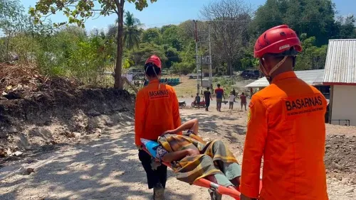
The Central Sulawesi provincial government declared a disaster emergency status on Wednesday, which will remain in force until 23 June to accelerate relief and assessment operations. Emergency supplies — including tents, food packages, mattresses, and blankets — have been dispatched to affected communities, with rescue teams continuing ground-level assessments.
Broader Regional Context
This comes amid an already heightened state of alert across the Indonesian archipelago. Earlier this month, on 8 June, the BNPB had urged coastal residents in northern Indonesia to evacuate to higher ground following a powerful 7.8-magnitude earthquake in the southern Philippines. Minor tsunami waves were detected at several coastal monitoring stations in northern Indonesia at the time, prompting warnings for provinces including North Sulawesi and Gorontalo. The Philippines quake had already caused widespread panic among residents in northeastern coastal areas of Indonesia.
Notably, Central Sulawesi has a documented history of seismic vulnerability — the province was devastated by the 2018 Palu earthquake and tsunami, which killed more than 4,300 people. The recurrence of significant seismic activity in the region underscores persistent risks for communities along the island's fault lines.
What Happens Next
The emergency status is set to run through 23 June, giving authorities a structured window for relief disbursement and damage assessment. The BNPB has indicated that ongoing aftershock monitoring will determine whether the emergency period is extended. Residents in affected villages, particularly in Sigi regency, are expected to remain in temporary shelters until structural safety checks are completed.
Point of View
In one sense, a relief — but the 6,412 people displaced and 108 injured tell a more sobering story about infrastructure fragility in Sigi regency. Central Sulawesi's seismic exposure is not new: the 2018 Palu disaster exposed catastrophic gaps in early warning and evacuation systems, and the region has never fully rebuilt. The fact that a 6.7-magnitude quake at 10 km depth — shallow enough to maximise surface damage — did not trigger a tsunami is fortunate, not a sign of reduced risk. With a 7.8-magnitude Philippines quake still reverberating through regional alert systems, Indonesian disaster authorities are managing compounding pressures across multiple provinces simultaneously. Whether the 23 June emergency window is sufficient for Sigi's damaged households is the question mainstream coverage is not asking.
NationPress
18 Sept 2026
Frequently Asked Questions
How strong was the earthquake that hit Central Sulawesi, Indonesia?
The earthquake measured 6.7 magnitude and struck on 17 June at 11:27 am local time , with its epicentre approximately 42 km southeast of Palu City at a depth of 10 km . Authorities confirmed it did not generate a tsunami.
What is the current death toll from the Central Sulawesi earthquake?
As of Thursday, 19 June , the National Disaster Management Agency (BNPB) confirmed three deaths , 17 serious injuries , and 91 minor injuries . A total of 6,412 people have been affected by the disaster.
Which area was worst hit by the earthquake?
Sigi regency was the most severely affected area, with damage reported across multiple villages. The disaster impacted 2,012 households , the majority of them in Sigi.
How long will the disaster emergency status last in Central Sulawesi?
The provincial government declared a disaster emergency status on Wednesday, 18 June , which is set to remain in effect until 23 June . The status was declared to speed up relief distribution and damage assessment operations.
Is there a risk of further earthquakes or tsunamis in the region?
Authorities have recorded at least 13 aftershocks following the main quake and have urged residents to avoid damaged buildings. The region was already on heightened alert after a 7.8-magnitude earthquake in the southern Philippines on 8 June prompted tsunami warnings along northern Indonesia's coastline.