7.0 magnitude earthquake strikes Tibet weeks after deadly flash floods

Synopsis
Tibet has been struck by a 7.0-magnitude earthquake — just weeks after a glacial avalanche triggered flash floods that killed over 1,455 people in Nepal and left hundreds missing on the Tibetan side. With the quake hitting at 173 km depth near Lhasa, experts warn the plateau is caught in an accelerating cycle of compounding disasters driven by climate change.
Key Takeaways
A 7.0 magnitude earthquake struck Tibet at 8:03 pm on 22 October , with the epicentre approximately 400 km from Lhasa .
The quake struck at a depth of 173 kilometres , according to India's National Centre for Seismology (NCS) .
The region is still recovering from flash floods triggered by an ice-rock avalanche near the Nepal-Tibet border on 26 August .
In Nepal , at least 1,455 people were killed and 5,285 remain missing; recovery is estimated to cost nearly $5 billion .
Chinese state media reported 43 deaths and over 500 missing on the Tibetan side of the border after the floods.
A previous 6.8-magnitude earthquake in January 2025 killed more than 120 people in the same region.
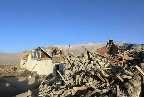
A powerful earthquake measuring 7.0 on the Richter scale struck Tibet at approximately 8:03 pm on Thursday, 22 October, raising fresh concerns about the region's compounding disaster burden — just weeks after catastrophic flash floods devastated communities along the Nepal-Tibet border.
According to India's National Centre for Seismology (NCS), the quake occurred at a depth of 173 kilometres below the Earth's surface, with the epicentre located roughly 400 kilometres from Lhasa, the Tibetan capital.
A Region Stacked With Recent Disasters
The latest seismic event compounds an already grim recent history for the Qinghai-Tibet Plateau. On 3 September, a magnitude 5.0 earthquake struck Tibet at a depth of approximately 14 kilometres. Before that, in January 2025, a major 6.8-magnitude earthquake — according to the China Earthquake Networks Centre — killed more than 120 people and injured hundreds more across the region.
Experts have warned that rising temperatures, retreating glaciers, and increasingly extreme weather events are heightening natural disaster risks across the plateau. The latest earthquake has, according to researchers, renewed urgent attention on the region's structural vulnerability as communities continue to grapple with the aftermath of successive crises.
The August Flash Floods and Their Devastating Toll
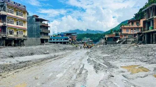
The earthquake follows by only weeks an ice-rock avalanche near the Nepal-Tibet border on 26 August, which triggered catastrophic flash floods. The floods swept away homes, roads, and bridges, damaged hydropower projects, and left thousands of people missing across the affected areas.
In Nepal, at least 1,455 people were killed, while 5,285 remained missing when authorities formally ended search and rescue operations. The Nepali government has estimated that nearly $5 billion will be required for early recovery and rehabilitation efforts to support the thousands displaced by the disaster.
Casualties on the Tibetan Side
On the Tibetan side of the border, Chinese state media reported 43 deaths and more than 500 people missing in connection with the floods. Earlier reports had placed the number of missing at 558, including 260 foreign nationals. However, the full extent of the destruction remains difficult to establish independently, given limited information emerging from the affected areas.
What Scientists Are Watching
Experts say the pattern of disasters — seismic activity, glacial avalanches, and flash floods occurring in rapid succession — is consistent with climate-driven amplification of natural hazard risks in high-altitude zones. The deep focal depth of Thursday's quake, at 173 kilometres, may have limited surface damage compared to shallower earthquakes of similar magnitude, though authorities had not issued a detailed damage assessment at the time of this report. All eyes remain on whether this latest tremor triggers secondary risks, including landslides or disruptions to glacial lakes already stressed by the August floods.
Point of View
Where seismic risk, glacial instability, and climate-driven extreme weather are converging. The January 2025 quake, the August avalanche-floods, and now a 7.0 tremor in October all point to a region under compounding stress that international disaster frameworks are not adequately equipped to monitor, given Beijing's restrictions on independent access. Nepal's $5 billion recovery bill — for a country with a GDP of roughly $40 billion — underscores how asymmetrically these disasters fall on smaller, less-resourced nations downstream. The opacity around Tibetan casualty figures is itself a geopolitical issue that humanitarian agencies have repeatedly flagged.
NationPress
22 Oct 2026
Frequently Asked Questions
How strong was the Tibet earthquake on 22 October 2026?
The earthquake measured 7.0 on the Richter scale and struck Tibet at approximately 8:03 pm on Thursday, 22 October . According to India's National Centre for Seismology, it occurred at a depth of 173 kilometres, with the epicentre about 400 kilometres from Lhasa.
What were the flash floods that hit Nepal and Tibet before this earthquake?
An ice-rock avalanche near the Nepal-Tibet border on 26 August triggered catastrophic flash floods that swept away homes, roads, and bridges. In Nepal alone, at least 1,455 people were killed and 5,285 remained missing after search and rescue operations were concluded.
How much will Nepal need to recover from the 2026 floods?
Nepal has estimated that nearly $5 billion will be needed for early recovery and rehabilitation efforts following the August floods. The disaster displaced thousands of people and caused widespread destruction of infrastructure, including hydropower projects.
Has Tibet experienced other major earthquakes recently?
Yes. A magnitude 5.0 earthquake struck Tibet on 3 September at a depth of approximately 14 kilometres. Before that, a 6.8-magnitude earthquake in January 2025 killed more than 120 people and injured hundreds, according to the China Earthquake Networks Centre.
Why is Tibet considered a high-risk zone for natural disasters?
Experts warn that rising temperatures, retreating glaciers, and increasingly extreme weather events are amplifying natural disaster risks across the Qinghai-Tibet Plateau. The combination of seismic activity and climate-driven glacial instability makes the region particularly vulnerable to cascading disasters.