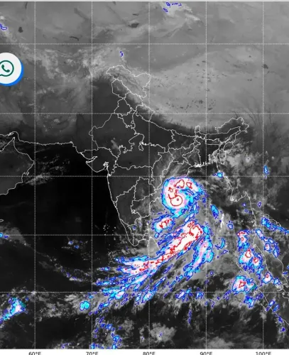
Cyclone Arnab landfall: 135 kmph winds lash Andhra Pradesh and Yanam coasts

Synopsis
Cyclone Arnab is making landfall right now along the Andhra Pradesh and Yanam coasts with winds up to 135 kmph and gusts of 150 kmph — and its reach extends far beyond the shoreline. A red alert is in force, multiple districts are bracing for extreme rainfall, and the storm's spiral bands are already pushing inland across Odisha, Telangana, and Jharkhand.
Key Takeaways
Very Severe Cyclonic Storm Arnab began landfall on 28 October 2026 along the Andhra Pradesh and Yanam coasts.
Maximum sustained wind speeds stand at 125–135 kmph , with gusts up to 150 kmph .
The cyclone is crossing the coast between Bapatla and Visakhapatnam , close to the south of Yanam .
The IMD has issued a red warning for extremely heavy rainfall in parts of Andhra Pradesh.
Heavy to very heavy rainfall is also forecast for south Odisha , eastern Telangana , and Jharkhand on 28–29 October.
The storm is being monitored by the Doppler Weather Radar at Machilipatnam ; APSDMA confirms landfall is ongoing.
Very Severe Cyclonic Storm Arnab began its landfall process early Wednesday, 28 October along the Andhra Pradesh and Yanam coasts, packing maximum sustained wind speeds of 125–135 kmph with gusts reaching 150 kmph, the India Meteorological Department (IMD) confirmed. The storm is crossing the coastline between Bapatla and Visakhapatnam, close to the south of Yanam, as conditions deteriorate rapidly across the region.
Position and Projected Track
As of 11:30 pm IST on Tuesday, the cyclone was centred over the west-central Bay of Bengal near latitude 16.3°N and longitude 82.1°E. It was positioned approximately 50 km east-southeast of Narsapur, 70 km south of Kakinada, 100 km east of Machilipatnam, 180 km east-northeast of Bapatla, and 200 km south-southwest of Visakhapatnam.
The IMD said the system was likely to move slowly northwestwards initially before recurving north-northwestwards. By the time of landfall, the cyclone's centre had closed to around 30 km from Narsapur and 55 km from Yanam, according to Prakhar Jain, Managing Director of the Andhra Pradesh State Disaster Management Authority (APSDMA). The storm is being continuously tracked by the Doppler Weather Radar stationed at Machilipatnam.
Districts on High Alert
Jain warned that Kakinada, Konaseema, and West Godavari districts faced gusty winds of 125–135 kmph over the hours immediately following the warning. The IMD noted that the storm's spiral band in its northern sector had already extended further inland, signalling that the cyclone was actively interacting with the land surface even before the core made contact.
A red warning for extremely heavy rainfall has been issued for parts of Andhra Pradesh and adjoining regions, with the IMD cautioning that the storm's impact would not be confined to the immediate coast.
Rainfall Forecast Across Multiple States
The IMD has forecast heavy to very heavy rainfall at a few places on 28 October, with extremely heavy rainfall at isolated locations in south Odisha. North Odisha may experience heavy to very heavy rainfall at isolated places, and interior Odisha could receive heavy rain on 29 October. Eastern Telangana is forecast to receive heavy to very heavy rainfall at isolated places on 28 October, while Jharkhand is expected to receive heavy rainfall on 28 October, intensifying to heavy-to-very-heavy at isolated spots on 29 October.
This is a significant multi-state weather event — cyclonic systems originating in the Bay of Bengal have historically caused prolonged inland flooding well after landfall, as moisture-laden remnants sweep northward through Odisha and into central India.
Disaster Response and Monitoring
The APSDMA has confirmed that the landfall process is actively continuing. Authorities across the affected districts are on high alert, with evacuation and relief operations under way in the most exposed coastal zones. The IMD has urged continuous monitoring of the evolving system as its effects spread across Andhra Pradesh and neighbouring states. All residents in the warned districts are advised to remain indoors and follow official guidance until the storm fully crosses the coast.
Point of View
Dense with population and agriculture — and its multi-state rainfall footprint means the damage accounting cannot stop at the Andhra shore. The IMD's red alert and APSDMA's active coordination suggest lesson absorption from past storms like Titli and Fani, where inland flooding killed more people than the initial landfall winds. The real test in the hours ahead is whether evacuation completeness and drainage infrastructure in Kakinada and Konaseema match the early warning quality that, to its credit, India has steadily improved over the last decade.
NationPress
28 Oct 2026
Frequently Asked Questions
Where is Cyclone Arnab making landfall?
Cyclone Arnab is making landfall along the Andhra Pradesh and Yanam coasts, crossing between Bapatla and Visakhapatnam, close to the south of Yanam, according to the IMD. The landfall process began early Wednesday, 28 October 2026.
What are the wind speeds of Cyclone Arnab?
The cyclone is packing maximum sustained wind speeds of 125–135 kmph, with gusts reaching up to 150 kmph at the time of landfall. Districts including Kakinada, Konaseema, and West Godavari are expected to face the brunt of these winds.
Which states are affected by Cyclone Arnab?
The primary impact zone is Andhra Pradesh, but the IMD has forecast heavy to very heavy rainfall across south and north Odisha, eastern Telangana, and Jharkhand on 28–29 October 2026. A red warning for extremely heavy rainfall is in force for parts of Andhra Pradesh.
What is the IMD's current warning for Cyclone Arnab?
The India Meteorological Department has issued a red warning for extremely heavy rainfall in parts of Andhra Pradesh and adjoining regions. The storm is being continuously monitored by the Doppler Weather Radar at Machilipatnam, and authorities have been advised to track the system closely as it moves inland.
What direction is Cyclone Arnab expected to move after landfall?
After landfall, the IMD expects Cyclone Arnab to move slowly northwestwards initially before recurving north-northwestwards. This track is likely to carry the remnant system's heavy rainfall deep into Odisha and central India over the following day.