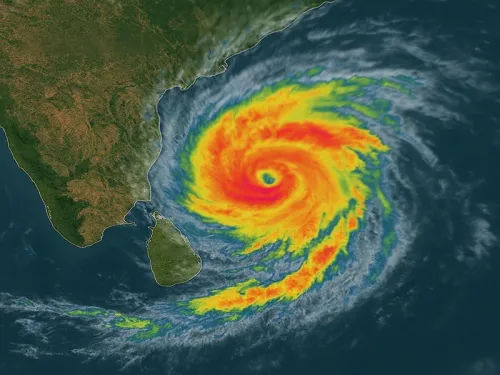
Cyclone Arnab: No direct Bengal hit, but heavy rain from Oct 27

Synopsis
Cyclone Arnab is not headed for West Bengal — but it is headed for Andhra Pradesh, and at extreme severity. With landfall forecast between Bapatla and Visakhapatnam by Wednesday afternoon and wind gusts up to 140 km/h, the storm is a serious coastal threat. Bengal will feel its edges through heavy rain, rough seas, and a fishermen's advisory from Tuesday.
Key Takeaways
Cyclone Arnab will not make direct landfall in West Bengal , confirms RMC Kolkata on 26 October 2025 .
The system is expected to intensify into an extremely severe cyclone and strike the Andhra Pradesh coast between Bapatla and Visakhapatnam by Wednesday afternoon .
Wind speeds at landfall projected at 115–125 km/h , with gusts up to 140 km/h .
Fishermen along the West Bengal coast have been advised to return to shore before Tuesday ; coastal winds of 35–55 km/h expected from Tuesday.
Heavy rain forecast in South 24 Parganas , East and West Midnapore , and Jhargram on Wednesday and Thursday .
Kolkata's minimum temperature on Sunday was 23.4°C ; a drop of 2–3 degrees expected after the storm passes.
The Regional Meteorological Centre (RMC), Kolkata confirmed on Sunday, 26 October 2025 that Cyclone 'Arnab' will not make direct landfall in West Bengal, but its influence will trigger scattered rain and thunderstorms across multiple districts from 27 to 30 October. The storm system, currently a depression over the east-central and adjacent southeast Bay of Bengal, is expected to intensify sharply in the coming days before striking the Andhra Pradesh coast.
Storm Track and Intensity
As of 11:30 pm on Saturday, the depression was positioned 470 kilometres north-northwest of Srivijayapuram in the Andaman Islands, 860 kilometres east-southeast of Visakhapatnam, and over 1,130 kilometres east of Bapatla in Andhra Pradesh. The system was moving southeast at 8 kilometres per hour.
According to the meteorological office, the depression will gradually move southward on Sunday before turning west-north-westward over the east-central Bay of Bengal. It is expected to intensify into a cyclone by Monday morning, at which point it will be formally named 'Arnab'. The system is forecast to further strengthen into a severe cyclone by Tuesday morning and a very severe cyclone thereafter, as it continues gathering energy over warm sea waters.
Landfall is projected on the Andhra Pradesh coast between Bapatla and Visakhapatnam by Wednesday afternoon, in an 'extremely severe' form. At landfall, wind speeds are expected to range between 115 and 125 kilometres per hour, with gusts potentially reaching 140 kilometres per hour.
Alert and Advisory for West Bengal
Although West Bengal is not in the direct path of the cyclone, the RMC Kolkata has issued a coastal alert effective from Tuesday. Fishermen have been advised to stay away from the sea after Tuesday; those already at sea have been instructed to return to shore before that deadline. Wind speeds of 35 to 55 kilometres per hour are expected along the West Bengal coast from Tuesday onwards, with seas turning rough under the influence of the low-pressure system.
District-Wise Rainfall Forecast for West Bengal
Heavy rain is likely in South 24 Parganas, East Midnapore, West Midnapore, and Jhargram on Wednesday and Thursday. Purulia and Bankura are also expected to receive heavy rainfall on Thursday. Scattered rain, thunderstorms, and lightning are forecast for Kolkata, Howrah, and Hooghly on Wednesday and Thursday, with conditions persisting in North 24 Parganas, East Burdwan, West Burdwan, Birbhum, Murshidabad, and Nadia from Wednesday through Saturday.
In North Bengal, heavy rain is likely in Darjeeling, Kalimpong, Jalpaiguri, and Alipurduar from Thursday, with scattered showers and thunderstorms expected across the remaining northern districts as well.
Temperature Outlook for Kolkata
The minimum temperature in Kolkata on Sunday morning was recorded at 23.4 degrees Celsius, marginally 0.4 degrees above normal. The maximum temperature on Saturday stood at 31.2 degrees Celsius, 0.5 degrees below normal. No major temperature change is expected over the next three days; however, the mercury could dip by two to three degrees thereafter, as the cyclone's aftermath pulls cooler air into the region.
With the system still intensifying at sea, residents of coastal Andhra Pradesh face the primary threat, while West Bengal should brace for disruptive rain and high winds from mid-week onward.
Point of View
And the advisory lag for fishermen in Bengal deserves attention. Historically, even indirect cyclone effects have caused flooding in low-lying South Bengal districts like South 24 Parganas. Authorities and residents should treat this as more than a weather footnote.
NationPress
25 Oct 2026
Frequently Asked Questions
Will Cyclone Arnab directly hit West Bengal?
No. The Regional Meteorological Centre in Kolkata has confirmed that Cyclone Arnab will not make direct landfall in West Bengal. However, its influence will bring scattered rain and thunderstorms to several districts between 27 and 30 October.
Where is Cyclone Arnab expected to make landfall?
Cyclone Arnab is forecast to make landfall on the Andhra Pradesh coast between Bapatla and Visakhapatnam by Wednesday afternoon in an 'extremely severe' form. Wind speeds at the time of landfall are expected to be between 115 and 125 km/h, with gusts up to 140 km/h.
Which districts of West Bengal will be most affected by Cyclone Arnab?
South 24 Parganas, East Midnapore, West Midnapore, and Jhargram are expected to receive heavy rain on Wednesday and Thursday. Purulia and Bankura will also see heavy rainfall on Thursday, while Kolkata, Howrah, and Hooghly face scattered thunderstorms from Wednesday.
What advisory has been issued for fishermen in West Bengal?
Fishermen along the West Bengal coast have been advised to stay away from the sea after Tuesday. Those already at sea have been instructed to return to shore before Tuesday. Coastal wind speeds of 35 to 55 km/h are expected from Tuesday onward.
When will Cyclone Arnab be officially named?
The depression over the Bay of Bengal is expected to intensify into a cyclone by Monday morning, at which point it will be officially named 'Arnab'. It is projected to further strengthen into a severe cyclone by Tuesday morning.