Cyclone Arnab: IMD red alert for Andhra coast, landfall near Yanam by Wednesday morning

Synopsis
Cyclone Arnab is hours from landfall on the Andhra Pradesh coast — and the warning signs are already visible. Trees down in Visakhapatnam, seawater on roads in Kakinada, and an IMD red alert covering five districts signal that the window for evacuation is closing fast. With winds forecast at up to 150 kmph, the next 12 hours are critical.
Key Takeaways
Very severe cyclonic storm Arnab is expected to make landfall between Bapatla and Visakhapatnam around 1130 IST on 28 October 2026 .
IMD has issued a red alert for Andhra Pradesh ; sustained winds of 125–135 kmph , gusting to 150 kmph , are forecast at landfall.
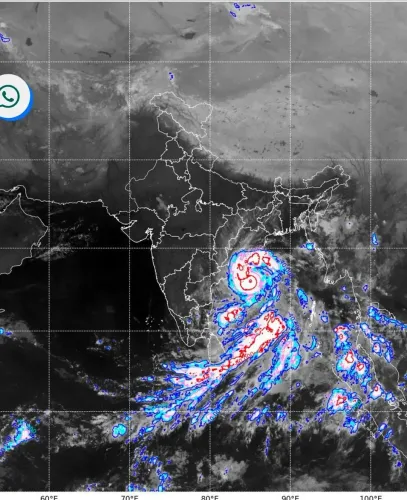
The storm was centred 140 km southeast of Kakinada and 170 km south of Visakhapatnam as of 1430 IST on 27 October .
Heavy to very heavy rainfall is expected in East Godavari , West Godavari , Kakinada , Konaseema , and Anakapalli districts through Wednesday morning.
Chandrababu Naidu has ordered full deployment of NDRF and SDRF teams and directed rehabilitation camps to be stocked with food and drinking water.
Fishermen have been evacuated from coastal villages; residents in huts and low-lying areas urged to move to relief shelters immediately.
Very severe cyclonic storm Arnab moved steadily closer to the Andhra Pradesh coast on Tuesday, 27 October 2026, prompting the India Meteorological Department (IMD) to issue a red alert for the state as it braces for landfall between Bapatla and Visakhapatnam on Wednesday. The storm, centred over the west-central Bay of Bengal, was tracking 140 km southeast of Kakinada at 1430 IST, and is expected to cross the Andhra Pradesh and Yanam coasts close to south of Yanam as a very severe cyclonic storm packing sustained winds of 125–135 kmph, gusting to 150 kmph, by around 1130 IST on 28 October 2026.
IMD Forecast and Storm Track
According to the latest IMD bulletin, Arnab moved west-northwestwards at 18 kmph over the past six hours and lay centred approximately 170 km south of Visakhapatnam, 230 km east of Machilipatnam, 300 km east-northeast of Bapatla, and 380 km south-southwest of Gopalpur in Odisha. The storm is forecast to continue moving nearly west-northwestwards before curving northwestwards ahead of the landfall event. Residents in its projected path have been urged to stay indoors and move to designated relief shelters.
Early Impact Along Coastal Andhra
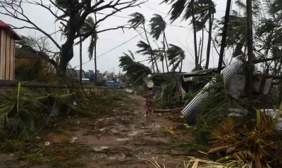
Coastal districts have already begun experiencing Arnab's outer bands. In Visakhapatnam, trees and electric poles were uprooted at several locations, and a few cars were damaged after a tree collapsed at MVP Sector 3. The Old Gajuwaka area was reported inundated. In Kakinada and Konaseema districts, massive waves crashed along the shoreline, with seawater breaching sand barriers and spilling onto roads. Gusty winds of 30–60 kmph were recorded along the coast. Fishermen from coastal villages were evacuated to safer locations as a precaution.
Administration on High Alert
Andhra Pradesh State Disaster Management Authority (APSDMA) Managing Director Prakhar Jain warned that heavy to very heavy rainfall is likely in East Godavari, West Godavari, Kakinada, Konaseema, and Anakapalli districts until Wednesday morning. 'The next 12 hours require utmost vigilance,' Jain said, adding that winds of 100–140 kmph are possible, and urged those living in huts and temporary shelters to immediately relocate to the nearest rehabilitation centres.
Kakinada Collector Harindhira Prasad and Superintendent of Police Bindu Madhav reviewed ground conditions at Talarevu. Control rooms have been activated across coastal districts to enable real-time monitoring by field officials.
Chief Minister Naidu Reviews Preparedness
Chief Minister N. Chandrababu Naidu held a teleconference with collectors of all coastal districts to take stock of the situation. He directed that all precautions be taken to prevent loss of life and property, and instructed officials to restore power supply as quickly as possible in case of disruptions. Naidu also ordered that food, drinking water, and other essentials be stocked at all rehabilitation camps, and emphasised relocating residents from low-lying areas to safe zones. He called for the full deployment of pre-positioned National Disaster Response Force (NDRF) and State Disaster Response Force (SDRF) teams.
What to Expect Next
With landfall expected in the early hours of Wednesday, 28 October 2026, conditions along the north Andhra coast are set to deteriorate sharply overnight. Post-landfall, heavy rainfall is expected to spread inland, and flash flooding remains a significant risk in low-lying and riverine areas. Authorities have cautioned that power outages and infrastructure disruption are likely, and have asked residents to follow official advisories closely until the storm weakens.
Point of View
Raising questions about the pace of permanent coastal infrastructure hardening relative to the speed of disaster response mobilisation. The state administration's teleconference model under Chandrababu Naidu is a visible improvement over past response timelines, but the recurring destruction of electric poles and inundation of the same low-lying localities in Visakhapatnam and Kakinada suggests that last-mile infrastructure resilience remains the unresolved gap. Early evacuation compliance — particularly among fishing communities — will determine the human cost more than any command-room directive. The next credible measure of institutional readiness will be how quickly power is restored post-landfall, a metric that past cyclone recoveries on this coast have repeatedly struggled to meet.
NationPress
27 Oct 2026
Frequently Asked Questions
When and where will Cyclone Arnab make landfall?
Cyclone Arnab is expected to cross the Andhra Pradesh and Yanam coasts between Bapatla and Visakhapatnam, close to south of Yanam, around 1130 IST on 28 October 2026. The IMD has categorised it as a very severe cyclonic storm at the time of landfall.
What wind speeds are forecast during Cyclone Arnab's landfall?
The IMD forecasts maximum sustained wind speeds of 125–135 kmph, with gusts reaching up to 150 kmph at the time of landfall. Coastal districts between Bapatla and Visakhapatnam face the highest wind risk.
Which districts are under red alert due to Cyclone Arnab?
The IMD has issued a red alert for Andhra Pradesh, with heavy to very heavy rainfall specifically expected in East Godavari, West Godavari, Kakinada, Konaseema, and Anakapalli districts through Wednesday morning, 28 October 2026.
What steps has the Andhra Pradesh government taken ahead of the cyclone?
Chief Minister N. Chandrababu Naidu held a teleconference with all coastal district collectors, directing full deployment of NDRF and SDRF teams and ensuring rehabilitation camps are stocked with food and water. Fishermen have been evacuated from coastal villages, and residents in huts and low-lying areas have been asked to move to the nearest relief shelters immediately.
What impact has Cyclone Arnab already caused before landfall?
Ahead of landfall, Visakhapatnam has seen trees and electric poles uprooted, car damage near MVP Sector 3, and inundation in Old Gajuwaka. In Kakinada and Konaseema, high waves have breached sand barriers and flooded coastal roads. Gusty winds of 30–60 kmph have been recorded along the coast.