Is Cyclone 'Ditwah' Bringing Heavy Rain to TN Tomorrow?

Synopsis
As Cyclone Ditwah approaches, Tamil Nadu braces for heavy rainfall. Meteorologists forecast significant weather changes, especially from Friday onwards. The public is urged to prepare for potential storm impacts. Stay informed!
Key Takeaways
Cyclone Ditwah is intensifying and expected to bring heavy rains.
Regions in north Tamil Nadu , Puducherry , and south Andhra Pradesh should prepare.
Storm warning signals are advised at key ports.
Residents should stay updated on weather alerts.
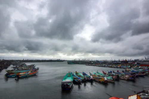
Chennai, Nov 27 (NationPress) A weather system developing over the southwest Bay of Bengal and the nearby Sri Lankan coast has evolved into a deep depression as of Thursday. Meteorologists have alerted that it could escalate into a cyclonic storm by Thursday evening.
The Regional Meteorological Centre (RMC) predicts that this system will head northwest across the southwest Bay and the Sri Lankan coastline, targeting north Tamil Nadu, Puducherry, and the adjacent south Andhra Pradesh coast by Saturday.
Once it gains cyclonic strength, it will be designated as Cyclone Ditwah, a name provided by Yemen as part of the tropical cyclone naming list established by the World Meteorological Organisation (WMO) and the UN Economic and Social Commission for Asia and the Pacific (UN-ESCAP).
The RMC has reiterated its predictions of heavy rainfall for south Tamil Nadu and the delta regions on Thursday, with a significant increase in rainfall expected across the state from Friday onwards.
Heavy to very heavy downpours are anticipated in the delta and surrounding areas on Friday, while north Tamil Nadu districts should brace for heavy rain on Saturday as the weather system progresses along the coast.
After a prolonged period of rainfall in the southern districts, the rain intensity diminished considerably on Wednesday.
During the 24 hours leading up to 8:30 a.m. on Thursday, only sporadic light showers were recorded.
Thangachimadam in the Ramanathapuram district reported the highest rainfall at 3 cm, while Oothu in Tirunelveli, which faced severe flooding earlier this week, noted 1 cm. In light of the expected intensification, the RMC has recommended the hoisting of storm warning signals at major ports, including Chennai, Cuddalore, Ennore, Thoothukudi, Nagapattinam, and Karaikal.
Mariners have been warned against venturing into the southwest Bay of Bengal and surrounding waters until further notice.
The latest forecast suggests isolated light rain over Kanniyakumari, Thoothukudi, and Tirunelveli districts as the deep depression continues to develop over the ocean.
Meanwhile, Cyclone Senyar, currently located over the coastal regions of northeast Indonesia and the adjacent Strait of Malacca, is projected to move eastward while maintaining its cyclonic storm status.
The RMC has confirmed that Senyar poses no threat to Tamil Nadu and will not affect weather patterns in the state.
Point of View
It's crucial to remain informed about Cyclone Ditwah's developments. As we anticipate heavy rains in Tamil Nadu, our responsibility is to ensure that all necessary precautions are communicated effectively to the public. The focus should be on safety and preparedness, and we must stand united with affected communities.
NationPress
8 Jul 2026
Frequently Asked Questions
What regions will be affected by Cyclone Ditwah?
Cyclone Ditwah is expected to impact north Tamil Nadu, Puducherry, and the adjacent south Andhra Pradesh coast.
When is the heavy rainfall expected?
Heavy rainfall is forecasted to begin on Friday, with increased intensity across the state.
Is there a warning for mariners?
Yes, mariners are advised against venturing into the southwest Bay of Bengal and surrounding areas due to potential storm conditions.