

Cyclone Murasu crosses Andhra coast near Ongole, winds gust to 120 kmph
Synopsis
Cyclone Murasu slammed into the Andhra Pradesh coast near Ongole in the early hours of Tuesday, with winds gusting to 120 kmph. Ten districts — from Nellore to West Godavari — are now on heavy-rain alert, and disaster authorities are urging residents to stay vigilant as conditions are expected to remain severe through the day.
Key Takeaways
Severe Cyclonic Storm Murasu crossed the Andhra Pradesh coast near Ongole between 3:30 am and 5:30 am IST on 3 November 2026 .
Winds were sustained at 100–110 kmph , gusting up to 120 kmph , at the time of landfall.
The storm was moving north-northwestward at 9 kmph during the preceding six hours.
Heavy rainfall alerts issued for West Godavari, Eluru, Krishna, NTR, Guntur, Bapatla, Palnadu, Markapuram, Prakasam and Nellore districts.
APSDMA and RTGS have urged residents in affected districts to remain on high alert and follow official advisories.
Severe Cyclonic Storm Murasu crossed the south Andhra Pradesh coast between Nellore and Narsapur, close to Ongole, in the early hours of Tuesday, 3 November 2026, packing sustained winds of 100–110 kmph gusting up to 120 kmph, the India Meteorological Department (IMD) confirmed. The crossing, which occurred between 3:30 am and 5:30 am IST, triggered heavy rainfall alerts across multiple districts in the state.
How the Cyclone Moved
According to the IMD, the storm moved in a north-northwestward direction and made landfall near Latitude 15.53°N, Longitude 80.22°E — close to Ongole. The cyclone was advancing at approximately 9 kmph during the six hours preceding landfall, according to the update issued by the Real Time Governance Society (RTGS) and the Andhra Pradesh State Disaster Management Authority (APSDMA).
At the time of the advisory, Murasu was centred approximately 20 km from Ongole, 60 km from Bapatla, 70 km from Kavali, 110 km from Nellore, and 130 km from Machilipatnam. The full landfall process was expected to take an additional two hours to complete from the time of the advisory.
Districts on High Alert
Prakhar Jain, Managing Director of the State Disaster Management Authority (SDMA) and CEO of RTGS, said isolated heavy rainfall was likely across West Godavari, Eluru, Krishna, NTR, and Guntur districts. Similar conditions were also forecast for Bapatla, Palnadu, Markapuram, Prakasam, and Nellore districts.
Authorities have urged residents across the affected belt to remain on high alert, warning that strong winds and heavy rain could persist well after the cyclone's passage over the coastline.
What Disaster Authorities Are Saying
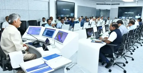
The APSDMA advised residents to take weather warnings seriously and stay indoors during the period of peak impact. Strong winds ranging from 100 to 120 kmph were expected to continue through the landfall process. This comes as the state government has pre-positioned disaster response teams across vulnerable coastal districts.
Broader Context and What Comes Next
The Andhra Pradesh coastline has historically been among the most cyclone-prone stretches in India, with the Bay of Bengal generating severe systems almost every pre- and post-monsoon season. Cyclone Murasu follows a pattern of late-October and early-November Bay of Bengal storms that have repeatedly tested the state's disaster preparedness infrastructure.
Residents in the affected districts have been advised to avoid coastal areas, secure loose structures, and follow official advisories as conditions are expected to remain severe in the hours ahead.
Point of View
Not a one-off crisis. The state has visibly improved its early-warning and evacuation infrastructure over the past decade, but the real measure is whether pre-positioned disaster teams translate into zero preventable casualties this time. The clustering of alerts across ten districts — spanning the Godavari delta down to Nellore — signals a wide damage corridor that will strain district-level response capacity simultaneously. National and state authorities should be tracking not just wind speed, but the hours after landfall, when flooding and infrastructure damage typically peak.
NationPress
3 Nov 2026
Frequently Asked Questions
Where did Cyclone Murasu make landfall?
Cyclone Murasu crossed the south Andhra Pradesh coast between Nellore and Narsapur, close to Ongole, on 3 November 2026. The IMD confirmed the crossing took place between 3:30 am and 5:30 am IST.
What wind speeds did Cyclone Murasu bring at landfall?
The storm packed sustained winds of 100–110 kmph, gusting up to 120 kmph, at the time of landfall. The cyclone was classified as a Severe Cyclonic Storm by the IMD.
Which Andhra Pradesh districts are on heavy-rain alert due to Cyclone Murasu?
Ten districts are under heavy-rainfall alerts: West Godavari, Eluru, Krishna, NTR, Guntur, Bapatla, Palnadu, Markapuram, Prakasam, and Nellore. Residents have been urged to stay alert and heed official warnings.
How fast was Cyclone Murasu moving at landfall?
According to RTGS and APSDMA, Murasu was moving at approximately 9 kmph in a north-northwestward direction during the six hours preceding its coastal crossing near Ongole.
What should residents in affected districts do during Cyclone Murasu?
Authorities have advised residents to remain indoors, avoid coastal areas, secure loose structures, and follow updates from the APSDMA and district administrations. Strong winds and heavy rainfall are expected to persist through and after the cyclone's landfall passage.