Cyclone warning signal No. 1 hoisted at 9 Tamil Nadu, Puducherry ports

Synopsis
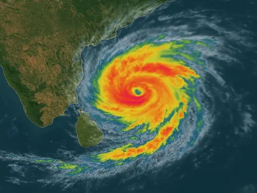
A Bay of Bengal weather system is on track to become a cyclone by Monday, prompting authorities to hoist warning signal No. 1 at nine ports across Tamil Nadu and Puducherry. The IMD forecasts landfall near Andhra Pradesh on the morning of 28 October — giving coastal communities and port operators a narrow window to prepare.
Key Takeaways
Cyclone warning signal No.
1 has been hoisted at nine ports across Tamil Nadu and Puducherry on 25 October 2026 .
Ports under alert: Chennai, Ennore, Kattupalli, Cuddalore, Thoothukudi, Pamban, Nagapattinam, Puducherry, and Karaikal .
The IMD expects the Bay of Bengal system to become a cyclone by Monday , after passing through depression and deep-depression stages over the weekend.
The system is forecast to cross the coast near Andhra Pradesh on the morning of 28 October .
1 is a preliminary alert — it does not indicate a direct threat to the ports displaying it, but signals conditions favourable for cyclone formation.
Cyclone warning signal No. 1 has been hoisted at nine ports across Tamil Nadu and Puducherry on 25 October 2026 as a weather system intensifying over the Bay of Bengal is expected to develop into a cyclone by Monday, according to officials. The India Meteorological Department (IMD) is closely tracking the system's westward movement toward the Andhra Pradesh coast.
Ports Under Warning
The nine ports placed under the preliminary warning are Chennai, Ennore, Kattupalli, Cuddalore, Thoothukudi, Pamban, Nagapattinam, Puducherry, and Karaikal. The alert applies to vessels and maritime operations along a significant stretch of India's southeastern coastline.
IMD's Intensification Forecast
According to the IMD, a low-pressure area over the central and adjoining southeast Bay of Bengal intensified into a well-marked low-pressure area on Saturday. The system is expected to strengthen into a depression and subsequently a deep depression by Sunday, before developing into a full cyclone on Monday while continuing to move west-northwestwards.
The weather system is forecast to cross the coast near Andhra Pradesh on the morning of 28 October. Its projected path keeps it over the central-west Bay of Bengal, though the precise timing and landfall location remain subject to further monitoring.
What Signal No. 1 Means
Signal No. 1 represents the earliest stage in India's port warning system. It indicates the presence of a weather disturbance with conditions favourable for cyclone formation — it does not signal an immediate or direct threat to the harbour displaying it. The distinction is critical: the warning communicates a developing situation to vessels and port users rather than an imminent strike.
Ports use a numbered warning system ranging from 1 to 11 to convey escalating levels of weather-related danger. Display methods vary: during daylight hours, cone-shaped bamboo structures are used to show the designated signal number, while coloured lights take over after dark.
What to Watch Next
With the system forecast to intensify through the weekend, authorities and residents along the Tamil Nadu, Andhra Pradesh, and Puducherry coastlines should track IMD updates closely. Strong winds are expected in the vicinity of the weather system, and higher-numbered signals could be hoisted at affected ports as the cyclone forms and its track becomes clearer ahead of the projected 28 October landfall.
Point of View
But its low number can lull coastal communities into a false sense of security. The IMD's compressed timeline — low pressure to potential cyclone in roughly 48 hours — leaves limited room for preparation, particularly for fishing communities and small vessel operators. Andhra Pradesh's coast has borne the brunt of late-October Bay of Bengal cyclones before; the question now is whether state disaster machinery activates early enough to matter, or waits for higher-numbered signals before mobilising.
NationPress
25 Oct 2026
Frequently Asked Questions
Which ports have been placed under cyclone warning signal No. 1?
Nine ports have been placed under cyclone warning signal No. 1: Chennai, Ennore, Kattupalli, Cuddalore, Thoothukudi, Pamban, Nagapattinam, Puducherry, and Karaikal. The alert covers a large stretch of Tamil Nadu and Puducherry's southeastern coastline.
When is the Bay of Bengal system expected to develop into a cyclone?
The IMD expects the weather system to intensify into a depression on Sunday and further develop into a cyclone by Monday. It is tracking a west-northwestward trajectory over the Bay of Bengal.
Where is the cyclone expected to make landfall?
The system is forecast to cross the coast near Andhra Pradesh on the morning of 28 October. The precise landfall location and timing remain subject to ongoing IMD monitoring and could shift as the storm develops.
What does cyclone warning signal No. 1 mean for ports?
Signal No. 1 is the earliest stage of India's port warning system, indicating a weather disturbance with conditions favourable for cyclone formation. It does not mean the port displaying it will be directly hit — it serves as a preliminary communication to vessels and port users about a developing situation.
How does the port warning signal system work?
India's port warning system uses numbered signals from 1 to 11 to convey escalating levels of weather danger. During the day, cone-shaped bamboo structures display the designated signal number; after dark, coloured lights are used instead. Higher numbers indicate greater severity and more immediate threat.