Jitendra Singh: Geospatial sector now a strategic national asset
Synopsis
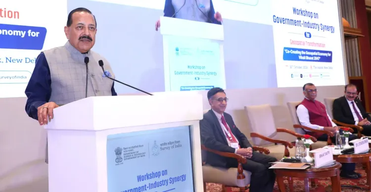
Union Minister Dr. Jitendra Singh, at a New Delhi workshop on 30 October 2026, declared geospatial data a strategic national asset, outlined a 12-13 year reform arc at Survey of India, and called for stronger public-private partnerships and geospatial AI adoption to power Viksit Bharat 2047.
Key Takeaways
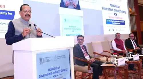
Jitendra Singh keynoted the workshop on 'Government and Industry Synergy for Geospatial Transformation' in New Delhi on 30 October 2026 .
He said 12 to 13 years of reforms have transformed the Survey of India from a labour-intensive mapping body to one using satellite, drone, and computer-based technologies.
The National Geospatial Policy 2022 provides an open framework that explicitly accommodates geospatial artificial intelligence.
The minister outlined an 'enable, invest and adopt' three-step roadmap for geospatial economic growth.
Startups and MSMEs are identified as key drivers of a commercial geospatial ecosystem through stronger public-private partnerships.
PM Modi's flagship agriculture and housing programmes are cited as priority sectors for geospatial solution adoption.
India's maps are no longer just paper — they are pipelines for economic growth. Delivering his keynote address at a high-level workshop on 'Government and Industry Synergy for Geospatial Transformation: Co-Creating the Geospatial Economy for Viksit Bharat 2047' in New Delhi on Friday, 30 October 2026, Union Science and Technology Minister Dr. Jitendra Singh declared that the geospatial sector has evolved from a purely technical mapping function into a 'strategic national asset for economic growth.'
From transit tables to satellite swarms: Survey of India's overhaul
The minister did not mince words about how far India's oldest scientific organisation has travelled. He told the audience that over the past 12 to 13 years, 'far-reaching geospatial reforms' have been undertaken and the 'work culture in the Survey of India has been totally overhauled.' The result: an institution once synonymous with labour-intensive field surveying now adapts satellite-based mapping, drones, and computer-based technologies as its primary instruments.
That transformation has an institutional anchor — the National Geospatial Policy 2022, which Dr. Singh described as an 'open framework' capable of accommodating emerging technologies, explicitly naming geospatial artificial intelligence. The policy built on the liberalisation of geospatial data guidelines introduced in February 2021, which stripped away layers of licensing restrictions that had long kept private players on the sidelines. Treating geospatial information as an economic multiplier rather than a restricted government function became the animating principle of both moves.
The 'enable, invest, adopt' playbook for Viksit Bharat 2047
Dr. Singh laid out a three-verb roadmap for the sector's next chapter: 'enable, invest and adopt.' Enabling, he explained, is about building confidence across government and industry. Investing means developing capability — in infrastructure, skills, and data assets. Adopting means deploying geospatial solutions at scale to generate measurable economic outcomes.
The minister pointed to Prime Minister Narendra Modi's flagship programmes in agriculture and housing as the most immediate terrain for this adoption push. Both sectors are data-hungry, spatially complex, and carry enormous policy weight — making them natural proving grounds for geospatial AI tools, drone surveys, and precision-mapping applications.
Startups and MSMEs as the growth engine
Perhaps the sharpest commercial signal of the keynote was Dr. Singh's call for 'stronger public-private partnerships to expand markets, develop viable business models and encourage startups and MSMEs.' The framing is deliberate: the government is signalling that geospatial data, once a closely guarded state resource, must now generate a commercial ecosystem. Startups and smaller enterprises are explicitly named as beneficiaries — and, implicitly, as the innovators expected to translate open data into market-ready products.
India's broader Digital India and Atmanirbhar Bharat programmes have consistently pushed geospatial modernisation since 2014, but the combination of the 2022 policy, a restructured Survey of India, and this renewed industry-engagement push marks a visible step-up in ambition. The next markers to watch: concrete public-private partnership models, pilot projects in agriculture and housing, and whether follow-up budget allocations emerge for geospatial AI development.
Point of View
PM Modi's agriculture schemes, and the startup ecosystem in a single address, the minister is explicitly linking geospatial reform to three of the current government's most visible political commitments — a choice that elevates the sector's budgetary and policy priority. Whether the PPP call translates into procurement frameworks and regulatory clarity for geospatial AI will determine if the ambition outlasts the keynote.
NationPress
30 Oct 2026
Frequently Asked Questions
What is the National Geospatial Policy 2022?
The National Geospatial Policy 2022 is an Indian government framework that liberalised access to geospatial data, removed earlier licensing restrictions on private players, and created an open architecture for emerging technologies including geospatial artificial intelligence.
What did Dr. Jitendra Singh say about geospatial sector reforms?
Dr. Singh said that over the past 12 to 13 years, far-reaching reforms have been undertaken, the work culture of the Survey of India has been overhauled, and the organisation has shifted from traditional surveying to satellite-based mapping, drones, and computer-based technologies.
What is Viksit Bharat 2047 and how does geospatial technology fit in?
Viksit Bharat 2047 is the Indian government's vision for India to become a developed nation by the centenary of independence in 2047. Dr. Singh linked geospatial transformation directly to this goal, arguing that adopting geospatial solutions in sectors like agriculture and housing will generate the economic growth required.
How are startups and MSMEs involved in India's geospatial sector?
Dr. Singh called for stronger public-private partnerships to help startups and MSMEs expand geospatial markets and develop viable business models, positioning smaller enterprises as key innovators in converting open geospatial data into commercial products.
What is the 'enable, invest and adopt' framework Dr. Jitendra Singh proposed?
Dr. Singh's three-verb roadmap means: enabling the ecosystem to build confidence in geospatial tools, investing to develop capability in infrastructure and skills, and adopting geospatial solutions at scale to generate measurable economic growth, particularly in agriculture and housing.