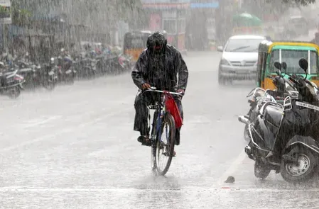
Tamil Nadu rain forecast: 12 districts on alert Sunday, north to stay warmer

Synopsis
Tamil Nadu is split in two by its own weather this weekend — twelve southern and western districts brace for rain and heavy hill showers from a Gulf of Mannar circulation, while the northern interiors face daytime temperatures sitting 3°C above normal through Wednesday. A textbook monsoon-transition divergence, but one with real risk of flooding in the Nilgiris and Theni hill belt.
Key Takeaways
The IMD has forecast rain across 12 Tamil Nadu districts on Sunday, 12 October , driven by a cyclonic circulation over the Gulf of Mannar .
Districts include Nilgiris , Coimbatore , Dindigul , Madurai , Thoothukudi , Tirunelveli , and Kanniyakumari , among others.
Heavy rain is specifically flagged for hilly areas of Coimbatore , Nilgiris , and Theni .
Monday's forecast covers seven districts , with Erode added and several Sunday districts dropped.
Northern interior Tamil Nadu faces maximum temperatures 3°C above normal through at least Wednesday, 15 October .
The India Meteorological Department (IMD) has forecast rain across 12 districts in Tamil Nadu on Sunday, 12 October 2025, driven by an upper-air cyclonic circulation persisting over the Gulf of Mannar and the adjoining southern Tamil Nadu coast. The system is positioned approximately 0.9 kilometres above mean sea level and is influencing weather conditions across the state's western, southern, and coastal belts.
Districts in the Rain Zone
The districts identified for Sunday's showers include Nilgiris, Coimbatore, Dindigul, Virudhunagar, Madurai, Sivaganga, Ramanathapuram, Thoothukudi, Theni, Tenkasi, Tirunelveli, and Kanniyakumari. Residents in these areas can expect moderate spells of rain accompanied by strong winds, according to the weather department.
The IMD has separately flagged the possibility of heavy rain in the hilly areas of Coimbatore district and in the Nilgiris and Theni districts, placing special emphasis on the western hill belt where intensity could exceed moderate levels elsewhere.
Monday Outlook: Seven Districts Remain Affected
For Monday, 13 October, the forecast narrows to seven districts — Nilgiris, Coimbatore, Erode, Kanniyakumari, Tirunelveli, Thoothukudi, and Tenkasi — all within the western belt and southern tip of the state. Notably, Erode enters Monday's list while several districts from Sunday's forecast, including Madurai, Sivaganga, and Ramanathapuram, are not included.
Northern Interiors Brace for Above-Normal Heat
In contrast to the wet conditions expected in the south and west, northern interior Tamil Nadu faces a different challenge. The IMD has warned that maximum daytime temperatures in these areas could remain three degrees Celsius above normal until at least Wednesday, 15 October. The temperature alert applies specifically to daytime maximums and does not signal a uniform statewide rise.
Why the Divergence Matters
The simultaneous rain-and-heat alert reflects Tamil Nadu's complex micro-climatic geography. The state's western ghats and coastal zones routinely receive the first influence of weather systems forming over the Bay of Bengal and the Gulf of Mannar, while the northern plains often remain dry and warmer under different pressure gradients. This comes amid the transition between the southwest and northeast monsoon seasons, a period when such split weather patterns are common across peninsular India. Residents in rain-flagged districts — particularly those in hill areas — are advised to remain alert to the possibility of localised flooding or landslides during heavy spells.
Point of View
Above-normal heat in the north — is a reminder that Tamil Nadu's weather governance challenge is structural, not seasonal. IMD advisories correctly flag the divergence, but district-level disaster preparedness in the Nilgiris and Theni hill belt remains the weak link: landslide-prone areas need real-time alerts, not just daily bulletins. The temperature warning for the northern interior also deserves more public-health communication than it typically receives, since heat-related illness peaks precisely when attention is focused on flood risk elsewhere in the same state.
NationPress
11 Oct 2026
Frequently Asked Questions
Which Tamil Nadu districts are forecast to receive rain on Sunday?
Twelve districts are in the rain forecast for Sunday, 12 October: Nilgiris, Coimbatore, Dindigul, Virudhunagar, Madurai, Sivaganga, Ramanathapuram, Thoothukudi, Theni, Tenkasi, Tirunelveli, and Kanniyakumari. The IMD attributes the showers to a cyclonic circulation over the Gulf of Mannar.
Is heavy rain expected anywhere in Tamil Nadu this weekend?
Yes. The IMD has specifically warned of heavy rain in the hilly areas of Coimbatore district and in the Nilgiris and Theni districts. These areas in the western hill belt are expected to receive more intense rainfall than the moderate showers forecast for the broader group of 12 districts.
What is causing the rain in southern and western Tamil Nadu?
An upper-air cyclonic circulation persisting over the Gulf of Mannar and the adjoining southern Tamil Nadu coast — located about 0.9 kilometres above mean sea level — is the primary driver. This kind of system is common during the transition between the southwest and northeast monsoon seasons.
Why are northern interior districts of Tamil Nadu expected to be warmer?
Northern interior Tamil Nadu sits under a different pressure gradient from the Gulf of Mannar system, leaving it largely dry. The IMD has warned that maximum daytime temperatures in these areas could remain 3°C above normal until at least Wednesday, 15 October.
Which districts feature in Monday's rain forecast?
Monday's forecast covers seven districts: Nilgiris, Coimbatore, Erode, Kanniyakumari, Tirunelveli, Thoothukudi, and Tenkasi. Erode is newly included, while several districts from Sunday's list — such as Madurai, Sivaganga, and Ramanathapuram — are not in the Monday outlook.