Super El Niño 2026: China warns 'prelude' already rivals 1997-98 disaster

Synopsis
China's chief El Niño forecaster warns the 2026 event already rivals the catastrophic 1997-98 super El Niño in intensity — and the worst impacts are expected to hit in 2027, not this year.
Key Takeaways
Jiang Hua , chief El Niño forecaster at the National Marine Environmental Forecasting Centre , stated on July 22, 2026 that the current event could rival the super El Niño of 1997-98 in intensity.
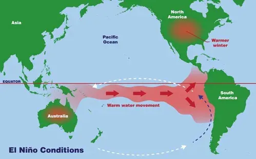
The tropical Pacific is exhibiting extreme warm-water conditions, described by Jiang as 'like a pot of boiling soup.' In March 2026 , researchers detected large anomalously warm water masses beneath the surface of both the Pacific and Indian Ocean .
Scientists warn that the most severe impacts of a super El Niño typically occur in the following year , meaning 2027 could be significantly worse.
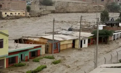
China has already experienced massive typhoons, severe flooding across major river systems, and extreme heat as part of this year's 'prelude' phase.
China is bracing for what climate scientists describe as a potential 'super' El Niño — a phenomenon whose most destructive phase may still lie ahead, even as 2026's early impacts already rival some of the worst climate disasters on record. Extreme typhoons, severe flooding, and scorching heatwaves have battered the country in rapid succession, with researchers pointing to an accelerating warm-water anomaly in the tropical Pacific as the driving force.
A 'Pot of Boiling Soup' in the Pacific
Jiang Hua, chief El Niño forecaster at the National Marine Environmental Forecasting Centre, issued a stark assessment in an interview with the Global Times on July 22. 'The entire tropical Pacific is like a pot of boiling soup,' she said, adding that in terms of intensity, 'this year's El Niño could already rival the historically recognised super El Niño of 1997-98.'
The 1997-98 super El Niño remains one of the most devastating climate events in modern history, responsible for widespread droughts, floods, and economic losses across multiple continents. That this year's event is already drawing comparisons to it — before reaching its peak — has alarmed forecasters.
Why It Matters: The Prelude Is Already Destructive
Jiang warned that although the most severe impacts of a super El Niño typically manifest in the following year, the current 'prelude' had already demonstrated 'extreme destructive power.' Rivers including the Yangtze, Pearl, and Songhua have seen abnormal water levels, while regions such as Hunan, Guizhou, and Inner Mongolia have reported acute weather stress.
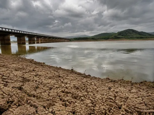
Scientists note that super El Niño events do not confine their damage to China — their reach extends across the Asia-Pacific, affecting monsoon patterns, agricultural output, and energy demand on a global scale.
The Science Behind the Surge
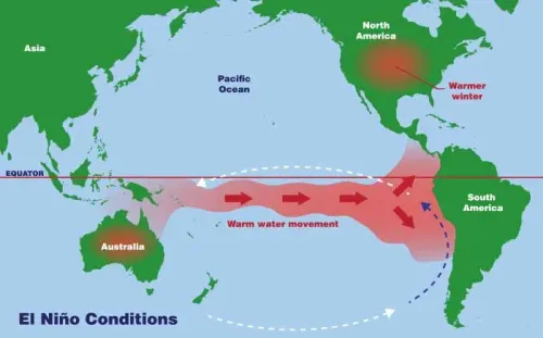
In March, Jiang and her team detected large volumes of anomalously warm water beneath the surface across tropical regions of both the northern and southern Pacific and the Indian Ocean. These warm-water anomalies, according to the researchers, are converging toward the central and eastern equatorial Pacific, accelerating the event's development.
The convergence pattern is consistent with the early-stage signatures observed before previous super El Niño cycles, lending credibility to the forecasters' concern that conditions could intensify significantly through the remainder of 2026 and into 2027.
Competitive Backdrop: Global Climate Models Under Pressure
The warning from the National Marine Environmental Forecasting Centre comes as meteorological agencies worldwide are under scrutiny for the accuracy of their El Niño intensity predictions. Early-detection failures ahead of the 1997-98 event cost governments critical preparation time, and the scientific community has since invested heavily in subsurface ocean monitoring.
Whether those investments translate into timely policy responses — particularly across vulnerable Asia-Pacific economies — remains an open question as the event continues to develop.
What's Next
Forecasters at the National Marine Environmental Forecasting Centre are monitoring whether the subsurface warm-water mass continues its eastward migration, which would confirm a full super El Niño classification. Governments across Southeast Asia, South Asia, and the broader Pacific basin are being urged to activate contingency plans for flooding, drought, and heatwave scenarios simultaneously. The critical window to watch is the transition from late 2026 into the first half of 2027, when historical precedent suggests peak destructive impact.
Point of View
Which historically is where preparedness gaps are most costly. Mainstream coverage tends to focus on current damage tallies, but the more consequential story is the subsurface ocean data from March that forecasters say is tracking ahead of the 1997-98 trajectory. That event caused an estimated $45 billion in global economic damage; a comparable or stronger event hitting a far more interconnected, infrastructure-dense Asia-Pacific in 2027 carries substantially higher exposure. The warning also puts pressure on international climate monitoring bodies to demonstrate that decades of investment in Pacific buoy networks and satellite oceanography can actually translate into actionable early-warning timelines.
NationPress
23 Oct 2026
Frequently Asked Questions
What is a super El Niño and how does it differ from a regular El Niño?
A super El Niño is an exceptionally intense warming of the central and eastern tropical Pacific Ocean that drives severe, widespread climate disruptions globally. It differs from a standard El Niño in the scale of sea-surface temperature anomalies and the geographic breadth of its impacts, including extreme floods, droughts, and heatwaves across multiple continents simultaneously.
How does the 2026 El Niño compare to the 1997-98 event?
According to Jiang Hua of the National Marine Environmental Forecasting Centre , the 2026 event could already rival the 1997-98 super El Niño in intensity. The 1997-98 event is considered one of the most destructive climate episodes of the 20th century, causing tens of billions of dollars in damage worldwide.
Why might 2027 be worse than 2026 for El Niño impacts?
Scientists explain that the most severe consequences of a super El Niño typically emerge in the year following its peak development phase. Since the current event is still intensifying as of mid-2026, the full force of its disruptions — including extreme flooding, agricultural failures, and heatwaves — is expected to materialise through 2027.
Which parts of China are already being affected by the 2026 El Niño?
Regions including Hunan , Guizhou , and Inner Mongolia have faced acute weather stress, while major river systems such as the Yangtze , Pearl , and Songhua rivers have recorded abnormal conditions. The country has simultaneously dealt with massive typhoons, severe flooding, and scorching heat.
What early warning signs did scientists detect in March 2026?
In March 2026 , Jiang Hua and her team identified large volumes of anomalously warm water beneath the surface across tropical regions of both the northern and southern Pacific and the Indian Ocean . These subsurface anomalies are now converging toward the central and eastern equatorial Pacific, accelerating the event's development.