Xinjiang floods expose infrastructure risk as Taklamakan rains surge
Synopsis
Two major floods struck China's Taklamakan Desert margins in June 2026 — a region whose roads, farms, and facilities were built for arid conditions. Experts warn the land simply cannot absorb sudden heavy rain, and the damage signals a structural mismatch between existing infrastructure and a rapidly changing climate.
Key Takeaways
Two major flood events struck the margins of the Taklamakan Desert in June 2026 , according to the China Weather Network .
Xu Xiaofeng , president of the China Meteorological Service Association and former deputy head of the CMA , warned that arid-zone land has limited capacity to absorb heavy rainfall.
Infrastructure across Xinjiang 's desert and Gobi zones was designed for low rainfall, strong winds, and large temperature swings — not intense precipitation events.
Warmer, wetter decades had previously made agriculture viable in Xinjiang , boosting food security, but extreme rainfall now threatens those gains.
Broader atmospheric shifts linked to warming over the Tibetan Plateau are driving anomalous moisture from the Indian Ocean and Arabian Sea deep into Central Asia .
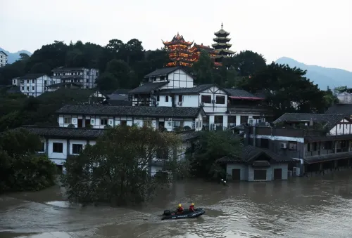
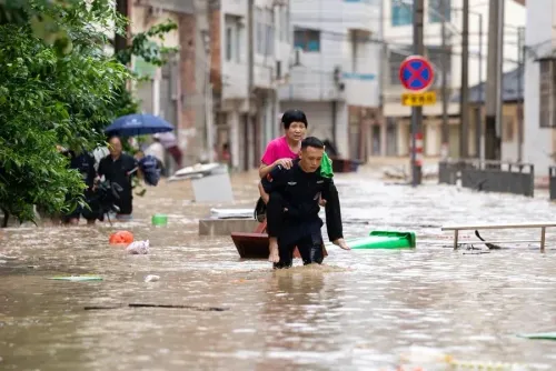
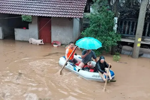
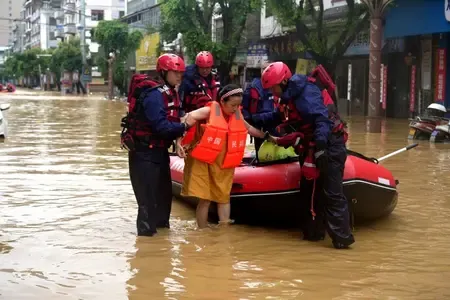
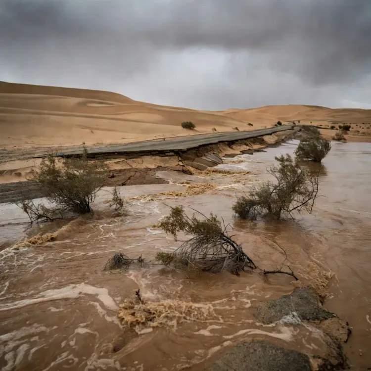
Xinjiang, China's vast northwestern region, is grappling with an unprecedented flooding crisis after rare but intense rainfall struck the margins of the Taklamakan Desert in June 2026, damaging roads and farmland and raising urgent questions about the resilience of infrastructure built for arid conditions.
Two major flood events in a single month
According to the China Weather Network, the public information platform of the China Meteorological Administration (CMA), two significant flood events have struck the edges of the Taklamakan Desert this month alone. The Taklamakan, long considered one of the world's most inhospitable desert environments, sits within the broader Tarim Basin and has historically received minimal rainfall. The back-to-back events mark a striking departure from historical norms.
Why it matters
Over recent decades, warmer and wetter conditions have gradually made agriculture viable in parts of Xinjiang that were previously too harsh for cultivation, contributing to China's food security goals. However, experts warn that more extreme and frequent rainfall now threatens to reverse those gains, eroding fragile ecosystems and overwhelming infrastructure that was never engineered to handle such volumes of water.
Xu Xiaofeng, president of the China Meteorological Service Association and former deputy head of the CMA, said the region faces compounding vulnerabilities. 'These regions have long been arid, with fewer rivers, lakes or ponds. That means the land has limited capacity to absorb heavy rainfall, making roads more vulnerable to washouts and farmland more susceptible to flooding,' he said.
Infrastructure built for the wrong climate
Xu further noted that facilities across Xinjiang's desert zones and the adjacent Gobi were designed specifically for arid conditions — accounting for low rainfall, strong winds, and large diurnal temperature swings — and have adapted to that environment over time. Sudden shifts in precipitation patterns mean these structures face stress loads they were never intended to withstand. Roads, irrigation channels, and agricultural installations in areas such as Hotan are among the most exposed assets.
The competitive backdrop: climate shifts reshaping Central Asia
The flooding is consistent with broader atmospheric changes affecting Central Asia and the Eurasian interior, where moisture from the Arabian Sea and the Indian Ocean is increasingly penetrating deep inland. Scientists have linked these shifts to accelerating warming over the Tibetan Plateau and Tibet, which alters jet-stream patterns and draws anomalous precipitation into historically dry zones. The trend poses long-term planning challenges for governments and infrastructure developers across the region.
What's next
Authorities and climate scientists are expected to reassess design standards for infrastructure in Xinjiang and similar arid-zone regions as extreme weather events become more frequent. The dual pressure of protecting newly cultivated agricultural land while retrofitting existing infrastructure for wetter conditions will test both engineering capacity and public investment budgets. How quickly China adapts its northwest development strategy to account for climate volatility will be closely watched by regional planners and international observers alike.
Point of View
But the deeper issue is that design standards for roads, irrigation, and settlements across the Tarim Basin may need to be overhauled at significant cost. As Indian Ocean moisture penetration into Central Asia intensifies, every nation with arid-zone infrastructure — from Kazakhstan to Iran — faces a version of the same reckoning.
NationPress
24 Jun 2026
Frequently Asked Questions
What caused the flooding in Xinjiang's Taklamakan Desert in 2026?
Rare but intense rainfall struck the margins of the Taklamakan Desert in June 2026, triggering two major flood events, according to the China Weather Network. Scientists link such anomalous precipitation to broader atmospheric shifts driven by warming over the Tibetan Plateau, which draws moisture from the Indian Ocean and Arabian Sea deep into Central Asia.
Why is Xinjiang's infrastructure particularly vulnerable to flooding?
Xinjiang's roads, farms, and facilities were engineered for arid conditions — low rainfall, strong winds, and large temperature swings — not intense rainfall events. Xu Xiaofeng, president of the China Meteorological Service Association, noted that the region has fewer rivers, lakes, or ponds, giving the land limited capacity to absorb sudden heavy rain.
How does extreme rainfall affect agriculture in Xinjiang?
While gradual warming and increased moisture over recent decades made agriculture viable in previously inhospitable parts of Xinjiang, extreme rainfall events now threaten to flood farmland and erode the ecological gains that underpinned that expansion. The dual risk — too little water historically, now too much at once — complicates long-term food security planning.
Who is Xu Xiaofeng and what did he say about the Xinjiang floods?
Xu Xiaofeng is the president of the China Meteorological Service Association and a former deputy head of the China Meteorological Administration (CMA). He warned that northwest China's ecosystems and infrastructure face greater climate risk than other regions because arid land cannot absorb heavy rainfall efficiently, making roads prone to washouts and farmland susceptible to flooding.
What broader climate trend does the Xinjiang flooding reflect?
The flooding is part of a wider pattern of increasing moisture penetration into Central Asia and the Eurasian interior, linked to warming over the Tibetan Plateau altering jet-stream dynamics. This trend affects arid-zone nations across the region and signals that infrastructure design standards built on historical climate data may be dangerously outdated.