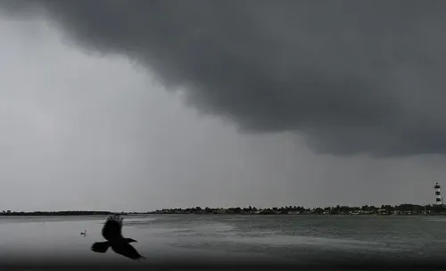


Cyclone Akvan: Heavy rain alert for Tamil Nadu on November 23-24

Synopsis
Cyclone Akvan has intensified into a very severe cyclonic storm and is set to make landfall between Narsapur and Puri on Friday with winds up to 110 kmph. Though Tamil Nadu escapes a direct hit, 14 of its southern and coastal districts — including the agriculturally critical Cauvery delta — are on alert for heavy rain on November 23 and 24.
Key Takeaways
Cyclone Akvan has intensified into a very severe cyclonic storm over the Bay of Bengal .
Landfall is expected between Narsapur, Andhra Pradesh and Puri, Odisha on Friday afternoon , with wind speeds up to 110 kmph .
Tamil Nadu will not see a direct landfall, but 14 southern and coastal districts face heavy rain alerts on 23 November .
Rainfall activity continues on 24 November , affecting Cuddalore , Thanjavur , Tiruvarur , Nagapattinam , and Pudukkottai .
Chennai is expected to remain largely dry on Thursday; Western Ghats districts may receive light rainfall.
The Cauvery delta farming belt stands to benefit from the anticipated fresh spell of rain linked to northeast monsoon activity.
Cyclone Akvan, which has intensified into a very severe cyclonic storm over the Bay of Bengal, is expected to make landfall between Narsapur in Andhra Pradesh and Puri in Odisha on Friday, even as Tamil Nadu's southern and coastal districts brace for heavy rainfall on 23 and 24 November. Wind speeds of up to 110 kmph are forecast at the time of landfall, according to the Meteorological Department.
Cyclone Track and Landfall Details
The cyclonic system developed over the central parts of the southern Bay of Bengal before undergoing a change in its trajectory and intensifying. The latest forecast indicates it will move in a north-northwestward direction, making landfall along the eastern coast on Friday afternoon. The projected landfall zone stretches between Narsapur, Andhra Pradesh and Puri, Odisha, placing the system well north of Tamil Nadu's coastline.
Notably, Cyclone Akvan is not expected to make landfall along the Tamil Nadu coast. Despite this, the broader atmospheric disturbance is forecast to trigger significant rainfall activity across the state from 23 November onwards.
Districts Facing Heavy Rain on November 23
The India Meteorological Department has issued a heavy rain forecast for isolated places across 14 districts on 23 November. These include Cuddalore, Thanjavur, Tiruvarur, Nagapattinam, Pudukkottai, Sivaganga, Ramanathapuram, Madurai, Virudhunagar, Theni, Tenkasi, Thoothukudi, Tirunelveli, and Kanyakumari.
Rainfall activity is set to persist on 24 November, with Cuddalore, Thanjavur, Tiruvarur, Nagapattinam, and Pudukkottai districts likely to receive continued heavy showers. The forecast represents a fresh spell of rain after a prolonged dry phase across large parts of Tamil Nadu.
Chennai and Western Ghats Outlook
Chennai is expected to remain largely dry on Thursday, 19 November, with the immediate impact of the cyclonic system concentrated farther north along the eastern coastline. Districts situated along the Western Ghats could receive light rainfall, but no heavy rain alert has been issued for those areas in the near term.
The weather department has cautioned that rainfall distribution and intensity could shift depending on atmospheric developments, and urged residents in affected districts to closely track subsequent weather bulletins.
Significance for the Cauvery Delta Region
The forecast carries particular relevance for the Cauvery delta region, where farming operations are closely tied to northeast monsoon activity. A fresh spell of rainfall at this stage of the agricultural calendar could benefit crops in an area that had been experiencing predominantly dry conditions. This comes amid broader concerns about the northeast monsoon's performance across Tamil Nadu this season.
The movement and intensity of Cyclone Akvan in the hours before and after landfall will remain the key variable shaping subsequent weather conditions across the region.
Point of View
Yet its atmospheric tail will deliver meaningful rainfall to districts that have seen a prolonged dry stretch — a reminder of how indirectly a Bay of Bengal system can reshape ground conditions hundreds of kilometres from the landfall zone. The more significant angle is agricultural: the Cauvery delta's northeast monsoon window is narrow, and a timely rain spell at this stage could ease distress in a farming belt already under stress. However, the same moisture surge that benefits crops can overwhelm drainage in coastal towns, and the rapid trajectory shift the system has already shown warrants caution about forecast certainty over the next 48 hours.
NationPress
19 Nov 2026
Frequently Asked Questions
Where will Cyclone Akvan make landfall?
Cyclone Akvan is expected to make landfall between Narsapur in Andhra Pradesh and Puri in Odisha on Friday afternoon, with wind speeds likely reaching 110 kmph. The cyclone is not forecast to make landfall along the Tamil Nadu coast.
Which districts in Tamil Nadu will receive heavy rain due to Cyclone Akvan?
On 23 November, heavy rain is forecast at isolated places in 14 districts: Cuddalore, Thanjavur, Tiruvarur, Nagapattinam, Pudukkottai, Sivaganga, Ramanathapuram, Madurai, Virudhunagar, Theni, Tenkasi, Thoothukudi, Tirunelveli, and Kanyakumari. Rainfall is expected to continue on 24 November, particularly in Cuddalore, Thanjavur, Tiruvarur, Nagapattinam, and Pudukkottai.
Will Chennai be affected by Cyclone Akvan?
Chennai is expected to remain largely dry on Thursday, 19 November, with the cyclone's immediate impact concentrated farther north along the eastern coastline. The city is not currently under a heavy rain alert for the coming days.
How intense is Cyclone Akvan?
The Meteorological Department has classified Cyclone Akvan as a very severe cyclonic storm. It developed over the central parts of the southern Bay of Bengal and has undergone a trajectory change while intensifying, with landfall wind speeds forecast at up to 110 kmph.
Why does the Tamil Nadu rain forecast matter for agriculture?
The anticipated rainfall is significant for the Cauvery delta region, where farming operations are closely linked to northeast monsoon activity. A fresh spell of rain after the prevailing dry conditions could benefit crop cycles in this agriculturally important belt of Tamil Nadu.