Delhi-NCR thunderstorms on 28 May bring relief from 44°C heatwave

Synopsis
After days pinned above 44°C, Delhi-NCR's heatwave broke on 28 May as thunderstorms driven by a Western Disturbance swept the capital and its satellite cities. The IMD now forecasts temperatures falling to the mid-30s by the weekend — and the pre-monsoon burst may be the earliest sign that the Southwest Monsoon's advance is on track.
Key Takeaways
Delhi-NCR received thunderstorm-driven rainfall on the evening of 28 May , ending a heatwave with temperatures above 44°C .
Winds gusted up to 80 kmph ; showers were reported across all zones of Delhi and in Gurugram, Noida, Ghaziabad, and Faridabad .
The IMD attributed the activity to a Western Disturbance and an upper-air cyclonic circulation.
Maximum temperatures are forecast to drop to 34–37°C on Friday and 34–36°C on Saturday; minimums to 22–25°C .
Thunderstorm activity with light to moderate rain is expected to continue over the next 3–4 days .
The IMD warned of possible damage to trees and power lines; residents advised to stay indoors during peak activity.
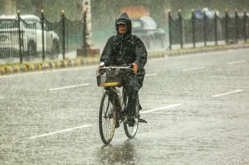
Delhi-NCR received long-awaited rainfall on Thursday, 28 May, as thunderstorms accompanied by light to moderate showers swept across the national capital and surrounding areas during the evening, snapping a prolonged heatwave that had pushed temperatures above 44 degrees Celsius. The India Meteorological Department (IMD) attributed the activity to a Western Disturbance and an upper-air cyclonic circulation.
What the IMD Forecast and What Happened
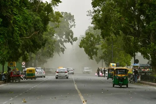
The Regional Meteorological Centre had predicted partly cloudy skies turning generally cloudy by the evening of 28 May, with very light to light rain, thunderstorms, lightning, and strong winds reaching 60–70 kmph, gusting up to 80 kmph. The forecast proved accurate, with scattered showers reported across North, South, East, West, and Central Delhi, as well as Gurugram, Noida, Ghaziabad, and Faridabad. A hailstorm was also likely at isolated places, according to the IMD.
Temperature Impact and Cooling Ahead
Maximum temperatures on Thursday had initially remained elevated at 40–42 degrees Celsius before dropping noticeably after the rain arrived. The IMD has forecast further cooling over the coming days, with maximum temperatures expected to settle between 34 and 37 degrees Celsius on Friday and between 34 and 36 degrees Celsius on Saturday. Minimum temperatures are projected to fall to 22–25 degrees Celsius, offering residents considerably more comfortable conditions after an extremely hot May.
Warnings and Safety Advisories
The strong winds and lightning accompanying the storms prompted the IMD to issue warnings about possible damage to trees, power lines, and vulnerable structures. Residents were advised to stay indoors during peak thunderstorm activity, avoid standing under trees, and unplug electrical appliances. Local authorities also urged citizens to remain cautious of waterlogging in low-lying areas and to follow traffic advisories.
Broader Significance: Monsoon Signals and Agricultural Outlook
The pre-monsoon activity is being seen as an early signal of the advancing Southwest Monsoon, which has already progressed over parts of the Arabian Sea and the Bay of Bengal. The IMD expects continued thunderstorm activity with light to moderate rainfall over Delhi-NCR during the next three to four days. The rains have also boosted hopes for improved agricultural prospects in surrounding regions. This comes amid one of the most intense pre-monsoon heat spells the capital has seen in recent years, making the relief all the more significant for its approximately 3 crore residents.
Point of View
And a single thunderstorm cannot substitute for structural urban-heat mitigation. The IMD's forecast of a return to the mid-30s is welcome, but the capital's heat-island effect means even those figures will feel harsher at street level than the numbers suggest. The real question is whether the Southwest Monsoon arrives on schedule or retreats, as it has in some recent years, leaving the city in a prolonged grey zone of humidity without rain.
NationPress
11 Oct 2026
Frequently Asked Questions
Why did Delhi-NCR receive rain on 28 May 2025?
The rainfall was triggered by a Western Disturbance and an upper-air cyclonic circulation, according to the IMD. These systems brought thunderstorms, lightning, and strong winds to the national capital and surrounding areas on the evening of 28 May.
How much did temperatures drop after the Delhi rain?
Maximum temperatures, which had been at 40–42°C earlier on Thursday, dropped noticeably after the evening showers. The IMD forecasts further cooling to 34–37°C on Friday and 34–36°C on Saturday, with minimums falling to 22–25°C.
Which areas of Delhi-NCR received rainfall?
Showers were reported across North, South, East, West, and Central Delhi, as well as the satellite cities of Gurugram, Noida, Ghaziabad, and Faridabad.
Is the Delhi rain linked to the Southwest Monsoon?
The IMD describes the activity as early pre-rainy season weather, noting that the Southwest Monsoon has already advanced over parts of the Arabian Sea and the Bay of Bengal. However, this specific spell was driven by a Western Disturbance, not the monsoon itself.
What safety precautions did authorities issue for the thunderstorms?
The IMD warned of possible damage to trees, power lines, and vulnerable structures due to strong winds and lightning. Residents were advised to stay indoors during peak thunderstorm activity, avoid standing under trees, unplug electrical appliances, and watch for waterlogging in low-lying areas.