What happened during the recent floods and landslides in Indonesia?
Click to start listening
Synopsis
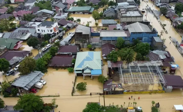
The catastrophic floods and landslides in Indonesia have led to a staggering loss of life, with hundreds affected. Rescue operations are underway, but many areas remain difficult to access. This devastating event underscores the region's vulnerability to natural disasters, prompting authorities to take immediate action.
Key Takeaways
- The floods and landslides in Indonesia have resulted in 174 fatalities.
- 79 individuals are currently missing.
- Rescue operations are hindered by inaccessible areas.
- Approximately 3,900 households have been displaced.
- A 6.3-magnitude earthquake struck the region as well.
Jakarta, Nov 28 (NationPress) The toll from the devastating floods and landslides that impacted Indonesia's Aceh, North Sumatra, and West Sumatra has tragically increased to 174 fatalities, with 79 individuals still unaccounted for and 12 others sustaining injuries, as reported by the National Disaster Management Agency (BNPB) on Friday.
BNPB Chief Suharyanto disclosed in a press briefing that North Sumatra bears the highest casualty count, with 116 deaths and 42 missing. Many affected regions are still unreachable due to compromised roads and persistent landslides, hampering rescue efforts.
“More victims may be trapped in landslide areas that are currently inaccessible,” Suharyanto stated, as reported by Xinhua news agency. In Aceh Province, 35 lives have been confirmed lost, with 25 individuals still missing and eight others injured.
West Sumatra reported 23 fatalities, with 12 missing and 4 injuries reported. Flooding and landslides have caused significant damage to roads and bridges across several districts, leading to approximately 3,900 households being displaced and seeking refuge in temporary shelters.
To mitigate further risks, the BNPB has initiated simultaneous Weather Modification Operations in the three affected provinces, aimed at redirecting rain clouds from high-risk areas.
Additionally, a 6.3-magnitude earthquake was recorded off the coast of Indonesia's Aceh province on Thursday morning, according to the country's meteorology and geophysics agency BMKG. The quake struck at 11:56 am local time, with an epicenter positioned 62 km northwest of Sinabang town on the eastern coast of Simeulue Island, occurring at a depth of 10 km.
A shakemap provided by BMKG indicated light to moderate shaking in parts of Simeulue Island and nearby areas, but there were no immediate reports of casualties or damage.
Indonesia is situated on the Pacific 'Ring of Fire', a region characterized by its frequent seismic activity due to the convergence of multiple tectonic plates.
Point of View
I emphasize our commitment to delivering accurate news about the ongoing crisis in Indonesia. The loss of life and ongoing struggles of the affected communities demand our attention and support. We stand dedicated to providing factual information and updates as the situation unfolds.
NationPress
28/11/2025
Frequently Asked Questions
What caused the floods and landslides in Indonesia?
The floods and landslides were triggered by heavy rainfall in the region, which is prone to such natural disasters.
How many people are missing after the disaster?
As of the latest reports, 79 individuals are still unaccounted for following the floods and landslides.
What measures are being taken for rescue operations?
Authorities have initiated rescue operations but face challenges due to damaged infrastructure and ongoing landslides.
What is the response from the BNPB?
The BNPB has launched Weather Modification Operations to divert rain clouds from high-risk areas to prevent further disasters.
Is there any earthquake activity in the region?
Yes, a 6.3-magnitude earthquake struck off the coast of Aceh province shortly after the floods and landslides.