Typhoon Saudel makes third landfall in Fujian, China with 23 m/s winds

Synopsis
Typhoon Saudel has now struck China's eastern coast three times — twice in Zhejiang on 28 August with Force 12 winds, and again in Fujian on Thursday morning. Nearly 250,000 residents were evacuated and over 80,000 emergency personnel mobilised, underlining the scale of a storm that refused to dissipate quickly.
Key Takeaways
Typhoon Saudel , the 18th typhoon of 2024, made its third landfall in Zhangpu County, Fujian at 6:30 am Thursday with winds of 23 m/s .
The storm first struck Zhejiang Province on 28 August with maximum winds of 35 m/s (Force 12) , followed by a second landfall near Wenzhou at 33 m/s .
Approximately 247,700 residents were evacuated from high-risk areas in Fujian by 7 am on 28 August .
More than 80,000 emergency personnel and 80,000 pieces of equipment were on standby in Fujian.
564 geological experts were deployed to 73 counties in Zhejiang; over 19,000 patrols were conducted at 7,200+ hazard sites.
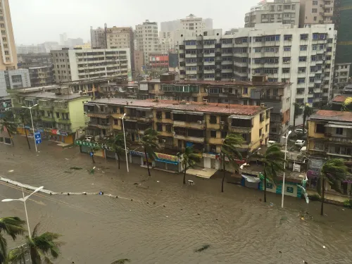
Typhoon Saudel, the 18th typhoon of the year, made its third landfall along the coast of Fujian Province in east China on Thursday morning, packing maximum sustained winds of 23 metres per second near its centre, according to the provincial meteorological observatory. The storm came ashore along the coast of Zhangpu County in Zhangzhou city at approximately 6:30 am.
A Storm That Has Struck Three Times
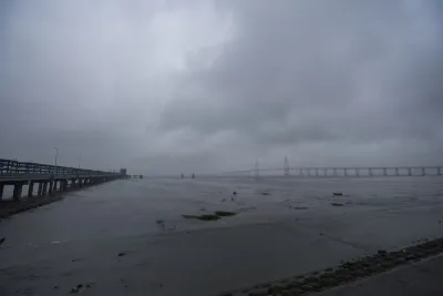
Saudel's destructive track began on 28 August, when it made its first landfall along the coast of Zhejiang Province at around 8:05 am, with maximum sustained winds of 35 metres per second — equivalent to Force 12 on the Beaufort scale. Less than 70 minutes later, at around 9:10 am, the typhoon struck again, making its second landfall along the coast of Wenzhou City in Zhejiang with winds of 33 metres per second. By the time it reached Fujian on Thursday, the storm had weakened but remained capable of causing significant disruption.
Emergency Response and Evacuations
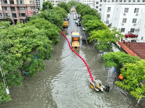
Authorities mounted a large-scale response ahead of the storm's arrival. Zhejiang Province raised its typhoon emergency response to Level I — the highest tier — on 27 August, enforcing a complete ban on people, vessels, and activities at sea. In Fujian, approximately 247,700 residents in high-risk areas had been evacuated by 7 am on 28 August, with more than 80,000 emergency personnel and 80,000 pieces of equipment placed on standby, according to the provincial flood control and drought relief headquarters.
Geological Risk Monitoring
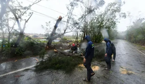
Zhejiang conducted extensive pre-landfall risk assessments. More than 4,000 monitoring personnel carried out over 19,000 patrols across more than 7,200 geological hazard sites and risk zones. Additionally, 564 geological experts were deployed to 73 counties to assist local authorities in identifying and managing ground-level risks — a scale of preparedness reflecting lessons from past typhoon seasons in the region.
National Alert and Forecast
The National Meteorological Centre issued a typhoon alert on the morning of 28 August, forecasting that Saudel would move southwest at 20 to 25 kilometres per hour and gradually weaken. The centre's projections proved broadly accurate, with the storm's wind speeds declining from 35 m/s at first landfall to 23 m/s by its third. Authorities are continuing to monitor the storm's trajectory as it moves further inland and dissipates.
Point of View
000 residents and the deployment of geological experts to 73 counties signal that Chinese authorities have institutionalised a high-tempo disaster response, but the real test will come in the damage and casualty assessment once the storm fully dissipates. Repeated landfalls from a single system are relatively rare and deserve closer scrutiny in regional climate trend analyses.
NationPress
3 Sept 2026
Frequently Asked Questions
Where did Typhoon Saudel make its third landfall?
Typhoon Saudel made its third landfall along the coast of Zhangpu County in Zhangzhou city, Fujian Province, east China, at approximately 6:30 am on Thursday. At that point, maximum sustained winds near the centre were recorded at 23 metres per second.
How many times did Typhoon Saudel make landfall in China?
Typhoon Saudel made landfall three times. It first struck Zhejiang Province on 28 August with Force 12 winds of 35 m/s, made a second landfall near Wenzhou in Zhejiang about an hour later at 33 m/s, and then came ashore a third time in Fujian on Thursday morning.
How many people were evacuated ahead of Typhoon Saudel?
Approximately 247,700 residents in high-risk areas of Fujian had been evacuated by 7 am on 28 August, according to the provincial flood control and drought relief headquarters. More than 80,000 emergency personnel and 80,000 pieces of equipment were also placed on standby.
What emergency level did Zhejiang raise ahead of the typhoon?
Zhejiang raised its typhoon emergency response to Level I — the highest level — on 27 August, enforcing a complete ban on people, vessels, and activities remaining at sea ahead of Saudel's arrival.
What is the forecast for Typhoon Saudel after its Fujian landfall?
The National Meteorological Centre had forecast that Saudel would move southwest at 20 to 25 kilometres per hour and gradually weaken. The storm's wind speeds had already declined from 35 m/s at first landfall to 23 m/s by its third strike, consistent with that projection.