CM Samrat Choudhary Reviews Bihar Flood Hazard Atlas 2026
Synopsis
Bihar Chief Minister Samrat Choudhary reviewed the Flood Hazard Zonation Atlas-2026 on 6 August 2026, a scientific mapping exercise by the Disaster Management Department to identify flood-prone zones and strengthen the state's pre-disaster preparedness and risk-reduction strategies.
Key Takeaways
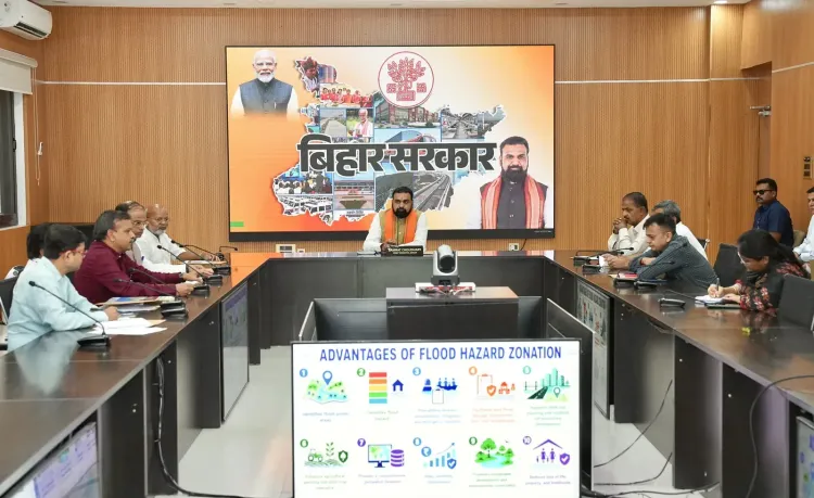
Bihar CM Samrat Choudhary reviewed the Flood Hazard Zonation Atlas-2026 on 6 August 2026 at Lok Sevak Aawas, Patna.
The atlas is designed to scientifically identify flood-prone zones across Bihar using modern technology and precise data.
The exercise is organised by the Bihar Disaster Management Department and aligns with national NDMA guidelines on GIS-based hazard mapping.
Bihar is particularly vulnerable to floods from the Ganges, Kosi, and Gandak river systems, with the 2008 Kosi floods a landmark disaster in the state's history.
The atlas is intended to strengthen early preparation, risk minimisation, and coordinated disaster response strategies at the district level.
Every monsoon, Bihar braces for a familiar reckoning — swollen rivers, submerged villages, and communities cut off for weeks. On Thursday, 6 August 2026, Bihar Chief Minister Samrat Choudhary took a step aimed at changing that cycle, chairing a review of the Flood Hazard Zonation Atlas-2026 at Sankalpan Sabhagar, Lok Sevak Aawas, organised by the state's Disaster Management Department.
The atlas, as described by the Chief Minister, uses scientific methods to identify flood-prone zones across the state — a foundation for sharper pre-disaster preparation, risk reduction, and coordinated response. In his post, Choudhary stated that the exercise will 'baadhh sambhavit kshetron ki vaigyanik pahchaan' (scientifically identify flood-prone areas) and strengthen disaster management strategies with precise data.
Why Bihar Needs a Flood Map More Than Most
Bihar sits at the confluence of some of the subcontinent's most volatile river systems — the Ganges, the Kosi, and the Gandak among them. The 2008 Kosi floods, triggered by a breach in Nepal, displaced millions and remain one of independent India's worst flood disasters. That catastrophe accelerated Bihar's investment in embankment works and periodic vulnerability assessments, but the gap between mapping and action has long frustrated planners.
The Disaster Management Act, 2005 gave states a legal mandate for hazard mapping and established state disaster management authorities. Since then, the National Disaster Management Authority has pushed states toward GIS-based atlases that shift the focus from post-disaster relief to pre-disaster risk reduction. Bihar's Flood Hazard Zonation Atlas-2026 is the state's latest contribution to that national pivot.
From Atlas to Action: What the Review Signals
Choudhary framed the atlas as a tool for three interlocking goals: scientific zone identification, effective early preparation, and risk minimisation. The state government, he said, is 'continuously working' — 'nirantar karyarat' — to make Bihar more disaster-resilient through modern technology, accurate data, and coordinated effort.
The immediate test will be whether the atlas findings feed into district disaster management plans, update early warning systems, and inform decisions on embankment reinforcement ahead of the monsoon peak. That integration — not the atlas itself — is where the real risk-reduction work happens.
Bihar's flood-prone communities have heard promises of better preparedness before. The atlas gives planners a sharper map. Whether it translates into fewer families on rooftops come August is the question that matters.
Point of View
The exercise also carries political weight: flood management is an annual credibility test for any Bihar government, given the state's near-certain monsoon exposure. The real policy signal to watch is whether the atlas findings are institutionalised into district plans and early warning infrastructure, or remain a mapping exercise on paper. If integrated effectively, it could mark a meaningful upgrade in how Bihar's most vulnerable communities experience the monsoon season.
NationPress
6 Aug 2026
Frequently Asked Questions
What is the Bihar Flood Hazard Zonation Atlas-2026?
It is a scientific mapping document prepared by Bihar's Disaster Management Department to identify flood-prone zones across the state, enabling better pre-disaster planning, risk reduction, and coordinated emergency response.
Why is Bihar so vulnerable to floods?
Bihar lies in the floodplains of major rivers including the Ganges, Kosi, and Gandak. These rivers, fed by Himalayan snowmelt and heavy monsoon rains, frequently breach banks or embankments, inundating large parts of the state every year.
What did CM Samrat Choudhary do on 6 August 2026?
Chief Minister Samrat Choudhary chaired a review meeting of the Flood Hazard Zonation Atlas-2026 at Sankalpan Sabhagar, Lok Sevak Aawas, Patna, organised by the Bihar Disaster Management Department.
How does the Flood Hazard Zonation Atlas help Bihar communities?
By scientifically identifying which areas face the highest flood risk, the atlas allows authorities to prioritise early warning systems, embankment reinforcement, and evacuation planning — reducing harm to flood-prone communities before disaster strikes.
What is India's national policy on flood hazard mapping?
Under the Disaster Management Act, 2005, and National Disaster Management Authority guidelines, Indian states are encouraged to develop GIS-based hazard atlases to shift disaster policy from post-event relief to pre-event risk reduction.