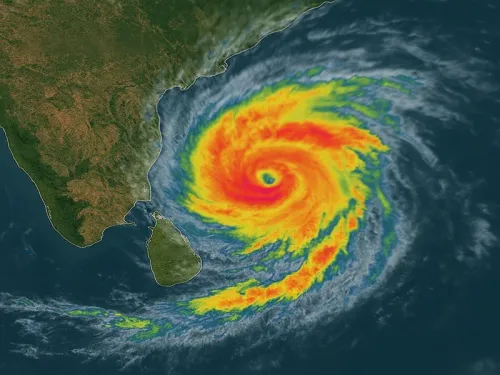
Cyclone Arnab likely to intensify today; heavy rain alert for TN, Andhra

Synopsis
A Bay of Bengal deep depression is set to become Cyclone Arnab by Monday, with landfall likely between Bapatla and Visakhapatnam on October 28. Tamil Nadu's southern and delta districts are already under heavy rain and thunderstorm warnings. The system could reach very severe cyclonic storm intensity before hitting the coast — making the next 48 hours critical.
Key Takeaways
A deep depression over the Bay of Bengal is expected to strengthen into Cyclone Arnab on Monday, 27 October , according to the India Meteorological Department .
The storm could intensify into a very severe cyclonic storm before making landfall between Bapatla and Visakhapatnam by the forenoon of 28 October .
The name Arnab was proposed by Bangladesh under the regional tropical cyclone naming arrangement for the northern Indian Ocean.
Heavy rain, thunderstorms, and winds of 40–50 kmph are forecast across multiple Tamil Nadu districts including Madurai , Nagapattinam , Tiruchirappalli , and Kanyakumari .
Exact track and intensity remain subject to evolving conditions; updated IMD bulletins over the next 48 hours will be crucial.
A deep depression over the Bay of Bengal is expected to strengthen into Cyclone Arnab on Monday, 27 October 2025, before intensifying further as it tracks toward the Andhra Pradesh coast, while several districts across Tamil Nadu brace for heavy rain, thunderstorms, and gusty winds. The India Meteorological Department (IMD) confirmed that the system had already intensified into a deep depression by Sunday and further escalation into a cyclonic storm was forecast within 24 hours.
Track and Projected Landfall
According to IMD, the system developed over the east-central and adjoining southeast Bay of Bengal before deepening. The storm is expected to move toward the Andhra Pradesh coast and could strengthen into a very severe cyclonic storm ahead of landfall. Forecasts indicate a possible coastal crossing between Bapatla and Visakhapatnam by the forenoon of 28 October, although officials caution that its exact track and intensity remain subject to subsequent weather bulletins as it evolves over the next two days.
What's in a Name: Arnab
The system will officially be designated Cyclone Arnab once it reaches cyclonic storm intensity. The name was proposed by Bangladesh under the regional naming arrangement for tropical cyclones over the northern Indian Ocean — a rotation system managed by the World Meteorological Organisation among member nations bordering the Bay of Bengal.
Tamil Nadu Districts on Alert
The IMD has forecast heavy rain at isolated places across a broad swathe of Tamil Nadu. Pudukkottai, Sivaganga, and Ramanathapuram are under warning for heavy showers accompanied by thunderstorms, lightning, and winds reaching 40–50 kmph. Similar conditions have been flagged for Kanyakumari, Tirunelveli, Thoothukudi, Tenkasi, Virudhunagar, and Madurai. Inland districts including Theni, Dindigul, Karur, and Tiruchirappalli are also expected to receive heavy rainfall with lightning and strong gusts.
In the Cauvery delta region, Thanjavur, Tiruvarur, and Nagapattinam could see heavy showers at one or two locations, accompanied by thunderstorms and gusty winds. The IMD notes that conditions could vary considerably within individual districts, with brief intense downpours and sudden gusts affecting some pockets more sharply than others. Warnings currently cover southern, central, and delta districts, placing a wide stretch of Tamil Nadu under the possibility of unsettled weather.
What Comes Next
The system's eventual severity and precise landfall point will depend on how it develops over the next 48 hours. Notably, the northeast coast of Andhra Pradesh — spanning Bapatla to Visakhapatnam — has historically been vulnerable to very severe cyclonic storms in late October and early November, a period that sits at the peak of the Bay of Bengal's cyclone season. Authorities in both Andhra Pradesh and Tamil Nadu are expected to activate disaster response protocols as updated IMD bulletins are issued. Citizens and fishing communities along the coast have been urged to track official advisories closely given the rapidly evolving nature of the system.
Point of View
And Arnab fits a pattern of systems that intensify rapidly in the final 48 hours before landfall — leaving a dangerously short preparation window. The stretch between Bapatla and Visakhapatnam is densely populated and includes critical port infrastructure; a very severe cyclone making landfall there would have outsized economic consequences beyond the immediate humanitarian risk. What mainstream coverage often underplays is the variability risk inside Tamil Nadu: the district-level warnings can mask hyper-local downpour spikes that overwhelm urban drainage. The IMD's own hedging on track and intensity is the honest signal here — this system still has room to surprise, in either direction.
NationPress
26 Oct 2026
Frequently Asked Questions
What is Cyclone Arnab and where did it form?
Cyclone Arnab is the name that will be assigned to a deep depression currently over the east-central and adjoining southeast Bay of Bengal once it reaches cyclonic storm intensity. The IMD reported that the system deepened into a deep depression on Sunday and is expected to become a cyclonic storm by Monday, 27 October.
Where is Cyclone Arnab expected to make landfall?
According to IMD forecasts, the storm could cross the Andhra Pradesh coast between Bapatla and Visakhapatnam by the forenoon of 28 October. However, its exact landfall point remains subject to further weather bulletins as the system continues to develop.
Why is the storm named Arnab?
The name Arnab was proposed by Bangladesh under the regional naming arrangement for tropical cyclones over the northern Indian Ocean, coordinated by the World Meteorological Organisation among Bay of Bengal member nations. Names are assigned in a pre-agreed rotation once a system reaches cyclonic storm intensity.
Which Tamil Nadu districts are under heavy rain alert?
The IMD has issued warnings covering a wide stretch of Tamil Nadu, including Pudukkottai, Sivaganga, Ramanathapuram, Kanyakumari, Tirunelveli, Thoothukudi, Tenkasi, Virudhunagar, Madurai, Theni, Dindigul, Karur, Tiruchirappalli, Thanjavur, Tiruvarur, and Nagapattinam, with heavy rain, thunderstorms, lightning, and winds of 40–50 kmph forecast.
How severe could Cyclone Arnab become?
The IMD has projected that the system could intensify into a very severe cyclonic storm before making landfall on the Andhra Pradesh coast. The final intensity will depend on conditions over the next 48 hours, and officials have urged reliance on updated official bulletins rather than preliminary estimates.