What Extensive Work is Underway Under Jal Shakti Abhiyan?

Synopsis
BJP MP Madan Rathore addresses crucial issues in water management and conservation, urging detailed insights from the Ministry of Jal Shakti on ongoing initiatives. The government’s commitment to digital monitoring and community engagement aims to enhance groundwater sustainability across India.
Key Takeaways
Community involvement is crucial for effective water management.
Digital monitoring systems enhance the efficiency of resource management.
The Atal Bhujal Yojana aims to improve groundwater sustainability.
Technological advancements are transforming the water management sector.
The government is committed to ensuring every state is self-reliant in water conservation.
Jaipur, Dec 2 (NationPress) BJP Rajya Sabha MP Madan Rathore highlighted a significant public interest matter during the proceedings of the House concerning water management, groundwater conservation, and the implementation of digital monitoring systems.
He requested comprehensive and explicit information from the Ministry of Jal Shakti regarding the current status of various water conservation initiatives being executed nationwide and their tangible effects on the populace.
MP Rathore particularly inquired about the advancements of the Atal Ground Water Scheme and the present condition of states and gram panchayats involved in it.
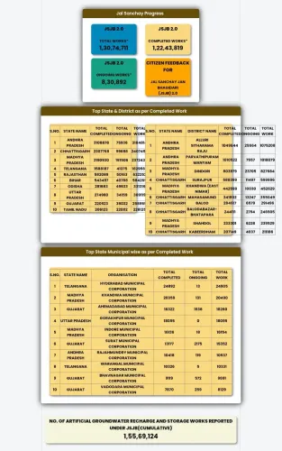
In response, Minister of State for Jal Shakti, Raj Bhushan Chaudhary, revealed that the Atal Bhujal Yojana (Atal Groundwater Scheme) is a community-driven program being rolled out in 8,203 Gram Panchayats across seven states—Gujarat, Haryana, Karnataka, Madhya Pradesh, Maharashtra, Rajasthan, and Uttar Pradesh—regions that have historically faced acute water shortages.
The Minister articulated that the primary aim of the initiative is to enhance groundwater levels, engage communities in water management, and reinforce demand-side regulations.
This scheme has markedly elevated awareness and involvement in responsible water usage throughout thousands of villages. He further noted that extensive efforts are ongoing across the nation under the Jal Shakti Abhiyan – Catch the Rain initiative.
The Geo-Mandal GIS platform and digital dashboard created by the Ministry of Jal Shakti serve as the foundation of this campaign. These platforms amalgamate real-time data from diverse states, thereby streamlining monitoring, evaluation, and assessment processes.
Moreover, the inclusion of geo-tagged data with the National Groundwater Information System (NAGIS) is equipping states with outstanding decision-making assistance.
Minister Chaudhary also emphasized that following November 2023, the piezometer network will be broadened to enhance groundwater monitoring. The quantity of groundwater observation wells has increased, and the digital water information system has undergone substantial upgrades. These measures are designed to ensure that water conservation activities are grounded in scientific, precise, and timely data. Under the National Groundwater Metering Program, IoT-based devices, groundwater sensors, and digital modules are utilized for the collection of high-resolution groundwater data, enabling the early detection of irregularities.
A national network of around 23,000 digital water level reporting stations has been established to continuously monitor groundwater patterns, diminishing reservoir capacities, and recharge rates—directly aiding states in crafting scientifically sound and effective water policies.
The Minister underlined that the National Water Informatics Centre now acts as the country’s central water data repository, aggregating vital information on topography, aquifer structure, flood analysis, and water quality, thereby furnishing a reliable technical foundation for the government.
In a similar vein, through a web-based Water Resources Information Management System developed by the Central Water Commission, reservoir levels and monthly water quality samples are being scrutinized at 592 dams throughout India. The nation’s water management sector is swiftly progressing toward digitalization, scientific accuracy, and transparency.
Combining community involvement with advanced technology and real-time data utilization is bolstering the country's ability to tackle future water challenges. The government's goal is to ensure that every state achieves self-sufficiency and technological empowerment in water conservation, groundwater management, and sustainable water use.
Point of View
It is imperative to recognize the government's proactive measures in addressing water scarcity. The integration of technology and community participation through the Jal Shakti Abhiyan reflects a significant commitment to sustainable development and resource management. It is crucial for every state to be empowered in these efforts.
NationPress
21 Jun 2026
Frequently Asked Questions
What is the Jal Shakti Abhiyan?
The Jal Shakti Abhiyan is a government initiative aimed at promoting water conservation and groundwater management across India.
How many states are involved in the Atal Ground Water Scheme?
The Atal Ground Water Scheme is being implemented in seven states: Gujarat, Haryana, Karnataka, Madhya Pradesh, Maharashtra, Rajasthan, and Uttar Pradesh.
What technology is being used for groundwater monitoring?
The government is utilizing IoT-based devices, groundwater sensors, and a national network of digital water level reporting stations to enhance groundwater monitoring.
What is the goal of the Atal Bhujal Yojana?
The primary goal of the Atal Bhujal Yojana is to improve groundwater levels and engage communities in effective water management.
How does the digital dashboard aid in water management?
The digital dashboard integrates real-time data from various states, facilitating effective monitoring and assessment of water resources.