CM Pema Khandu Uses Siang River to Signal Resilience Amid China Water Concerns
Synopsis
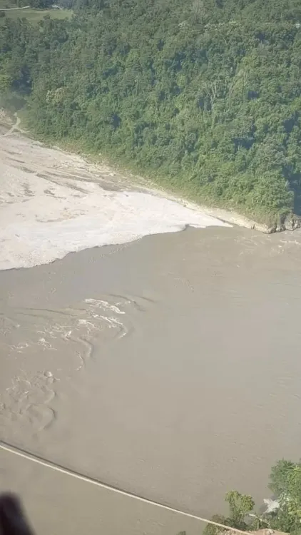
CM Pema Khandu posted a video contrasting the muddy, Tibet-fed Siang river with a clean local tributary, using the image to call for resilience-building over India's limited upstream control of the transboundary waterway.
Key Takeaways
Arunachal Pradesh CM Pema Khandu posted a video on 29 September 2026 contrasting the muddy Siang river — fed from Tibet — with a clean local tributary.
The Siang is the Indian reach of the Yarlung Tsangpo , which originates in Tibet and enters India through Arunachal Pradesh before becoming the Brahmaputra .
India and China established an Expert Level Mechanism in 2006 for sharing flood-season hydrological data on the Brahmaputra basin.
The Brahmaputra Board has coordinated flood and erosion management in the northeast since 1980 , but has no authority over upstream conditions in China.
Khandu framed the visual contrast as a call to 'prepare, strengthen and build resilience' on India's side of the watershed.
Downstream communities in Assam are also directly exposed to any deterioration in water quality or flow patterns from upstream.
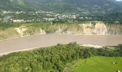
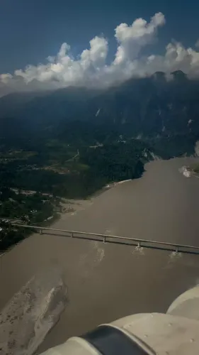
Two rivers tell a story that no diplomat needs to translate. Arunachal Pradesh Chief Minister Pema Khandu stood before the Siang river on Tuesday, 29 September 2026, and let the water speak first — muddy, sediment-heavy, carrying whatever Tibet sent downstream — before pointing to a clean, clear tributary rising entirely from Indian soil.
'We may not have control over what the Siang brings to us from upstream,' Khandu wrote. 'But we do have control over what we do on our side. We must prepare, strengthen and build resilience, so that what we cannot control does not overwhelm us.'
Where the Siang Comes From — and Why That Matters
The Siang is no ordinary river. It enters Arunachal Pradesh as the lower course of the Yarlung Tsangpo, which begins in Tibet and descends through one of the deepest gorges on Earth before crossing into India. By the time it reaches the state, it carries not just water but sediment, pollutants, and — critically — whatever upstream engineering China chooses to impose. India has limited legal recourse over what flows across that border.
The discolouration Khandu filmed is a visible, recurring symptom of this asymmetry. India and China established an Expert Level Mechanism in 2006 to share flood-season hydrological data on the Brahmaputra basin — of which the Siang is the Arunachal stretch — but critics have long argued the arrangement is too thin for a river system that drains the livelihoods of millions. The Brahmaputra Board, constituted in 1980, coordinates flood and erosion management across the northeast, yet the upstream variable remains outside its reach.
A Clean Tributary as Political Counter-Argument
The rhetorical move Khandu made is precise. By juxtaposing the murky Siang against a clear local tributary, he shifted the conversation from complaint to agency. The subtext is pointed: Arunachal Pradesh can protect its own waterways, manage its own side of the basin, and refuse to be defined by what arrives uninvited from across the border.
That framing resonates well beyond the environment beat. Arunachal Pradesh sits at the intersection of India's most sensitive territorial and strategic concerns — a state that China officially disputes, whose rivers feed Assam and the broader northeast, and whose communities are the first to absorb any upstream shock. Successive state governments have linked local resilience work to strategic preparedness, and Khandu's post follows that exact thread.
What 'Resilience' Looks Like on the Ground
Downstream communities in Assam — who receive the Siang after it widens into the Brahmaputra — are equally exposed. Seasonal flooding and erosion already displace hundreds of thousands every monsoon. A degraded water quality signal from the Tibetan plateau compounds that vulnerability. Khandu's call to 'prepare, strengthen and build resilience' is, in practical terms, a call for embankment reinforcement, early-warning systems, and stricter controls on the Indian side of the watershed.
The next round of India-China Expert Level Mechanism talks on transboundary rivers will be a telling indicator of whether New Delhi can extract stronger data-sharing commitments — or whether states like Arunachal Pradesh must continue building their defences largely on their own terms.
The Siang's muddy current is not a new problem. But a chief minister holding the camera to it — and naming the lesson plainly — is a reminder that some geopolitical realities flow whether or not anyone is watching.
Point of View
Giving the Centre political cover while also pressing for stronger bilateral data-sharing. The timing matters: as India-China relations navigate a delicate post-Galwan normalisation, a chief minister highlighting upstream water asymmetry keeps pressure on New Delhi to extract more from the Expert Level Mechanism without escalating the diplomatic register. If the post spurs a concrete state announcement on Siang basin management, it will mark a shift from symbolism to policy.
NationPress
29 Sept 2026
Frequently Asked Questions
Why is the Siang river muddy in Arunachal Pradesh?
The Siang carries heavy sediment loads from its Tibetan source as the Yarlung Tsangpo, including material disturbed by upstream activity in China, before entering Arunachal Pradesh. India has limited control over upstream conditions.
What is the Yarlung Tsangpo and how is it connected to the Brahmaputra?
The Yarlung Tsangpo originates in Tibet and descends through a deep gorge into Arunachal Pradesh, where it is called the Siang. It then flows into Assam, where it becomes the Brahmaputra, one of the largest river systems in Asia.
Does India have a water-sharing agreement with China on the Brahmaputra?
India and China established an Expert Level Mechanism in 2006 for sharing hydrological data during the flood season on the Brahmaputra basin, but there is no comprehensive water-sharing treaty governing upstream use.
What is the Brahmaputra Board and what does it do?
The Brahmaputra Board was constituted in 1980 to coordinate flood control, erosion management, and water resource development across the northeastern river basins, though its jurisdiction covers only the Indian side of the watershed.
What did CM Pema Khandu say about the Siang river?
Khandu posted a video contrasting the muddy, upstream-fed Siang with a clean local tributary and called for resilience-building, saying India may not control what arrives from upstream but must 'prepare, strengthen' on its own side.