Tamil Nadu to Utilize Drones and AI for Mapping Blue Carbon Ecosystems
Synopsis
Tamil Nadu is pioneering a groundbreaking initiative to map its coastal blue carbon ecosystems using advanced technologies such as drones and AI. This project aims to create a detailed Blue Carbon Atlas, enhancing the state's ability to engage in global carbon markets while contributing to conservation efforts.
Key Takeaways
Tamil Nadu is leveraging drones and AI for accurate mapping of blue carbon ecosystems.
A comprehensive Blue Carbon Atlas will be developed to support conservation efforts.
High-resolution data will enhance participation in global carbon markets.
The project aims to identify and restore degraded mangrove areas.
Collaboration with Microsoft and MSSRF showcases innovative approaches to environmental challenges.
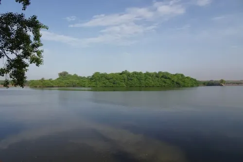
Chennai, March 5 (NationPress) Tamil Nadu is embarking on a remarkable scientific journey to accurately chart its coastal blue carbon ecosystems, which comprise mangroves, seagrass meadows, and tidal marshlands, through the utilization of drones, Artificial Intelligence, and cloud computing.
This initiative is designed to produce high-resolution data on the carbon stored in these ecosystems and to create a comprehensive Blue Carbon Atlas for Tamil Nadu, potentially positioning the state to engage in global carbon markets. Current estimates indicate that Tamil Nadu encompasses approximately 90 sq km of mangroves, 800 sq km of seagrass beds, and around 64 sq km of tidal marshlands. Nevertheless, scientists express concern over the reliability of these figures, as comprehensive mapping of these ecosystems has yet to be performed.
The existing data primarily relies on extrapolated findings from limited field samples scattered across extensive coastal regions, leading to discrepancies between state and national estimates. Researchers emphasize that precise measurements are essential for the scientific validation and potential trading of carbon stored in these ecosystems within international carbon markets.
To bridge this gap, scientists from the M.S. Swaminathan Research Foundation (MSSRF), in collaboration with the Tamil Nadu Forest Department and with technical backing from Microsoft, have initiated a project to map these ecosystems with unprecedented accuracy.
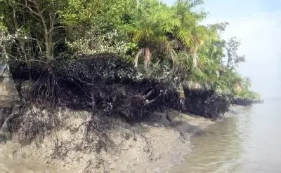
“Mangroves sequester nearly five times more carbon than terrestrial forests,” stated R. Nagarajan, who heads GIS and remote sensing at MSSRF and is spearheading the project. “This initiative will assist us in determining the precise extent of mangroves, as well as identifying degraded regions that can be rehabilitated, thus enabling the government to allocate resources for conservation and restoration efforts more effectively.”
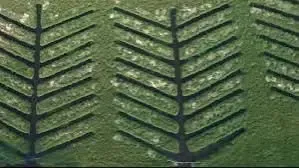
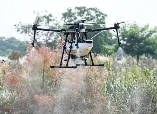
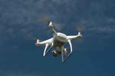
The mapping endeavor will employ military-grade drones outfitted with multispectral sensors, which can capture images with a resolution of 2-5 centimeters, significantly enhancing the clarity compared to previous satellite-based mapping that typically achieves around 10-meter resolution.
The sensors will empower scientists to analyze vegetation characteristics and accurately classify different mangrove species. Additionally, Light Detection and Ranging (LiDAR) technology will be utilized to assess canopy height, a vital factor in estimating forest biomass.
Data obtained from drones will be merged with satellite imagery and verified using ground-based field samples.
Ultimately, each pixel in the mapped imagery will be assigned a specific carbon value, allowing for precise calculations of both above-ground and below-ground carbon stocks in mangrove ecosystems.
The study will also encompass the mapping of tidal marshlands adjacent to mangrove habitats. Mapping seagrass meadows introduces further challenges, as drones operating at 15 meters above the surface can only identify vegetation up to approximately five meters underwater.
Nonetheless, critical marine regions such as the Gulf of Mannar and Palk Bay, which are home to extensive seagrass beds and support endangered dugongs under a national conservation initiative, will be included in the survey.
Scientists assert that this project will culminate in both digital and printed editions of the Blue Carbon Atlas, providing policymakers and conservationists with a vital resource for safeguarding coastal ecosystems while investigating climate finance opportunities.
Point of View
This initiative by Tamil Nadu reflects a proactive approach to environmental conservation and climate change mitigation. By leveraging advanced technologies, the state not only aims to enhance its ecological data but also to engage in global climate finance, setting a precedent for other regions.
NationPress
3 Jul 2026
Frequently Asked Questions
What are blue carbon ecosystems?
Blue carbon ecosystems include mangroves, seagrass meadows, and tidal marshlands that capture and store carbon, playing a critical role in mitigating climate change.
How will drones be used in this project?
Drones equipped with advanced sensors will collect high-resolution imagery to map the extent and health of blue carbon ecosystems in Tamil Nadu.
What is the significance of the Blue Carbon Atlas?
The Blue Carbon Atlas will provide essential data for conservation efforts and enable Tamil Nadu to participate in global carbon markets, enhancing its climate finance opportunities.
Why is precise mapping important?
Accurate mapping is crucial for validating carbon storage estimates and ensuring effective conservation strategies and potential trading in carbon markets.
What areas will be covered in the mapping project?
The project will cover mangroves, tidal marshlands, and seagrass meadows, particularly focusing on critical regions like the Gulf of Mannar and Palk Bay.