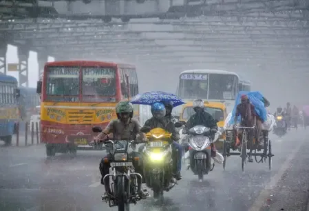
Heavy rain alert for North Bengal till Aug 5; South Bengal also on watch

Synopsis
A low-pressure system and an active monsoon axis are together directing heavy to very heavy rainfall into North Bengal through 5 August, with five districts — including Darjeeling and Jalpaiguri — set to receive up to 20 cm. South Bengal is simultaneously bracing for thunderstorms and 40 km/h gusts, making this one of the more widespread monsoon spells to hit the state this season.
Key Takeaways
The Meteorological Department has forecast heavy to very heavy rain in North Bengal through Wednesday, 5 August .
Darjeeling , Kalimpong , Jalpaiguri , Alipurduar , and Cooch Behar may receive 7 to 20 cm of rainfall.
South Bengal districts face thunderstorms with gusty winds of 30–40 km/h ; heavy rain warning issued for North 24 Parganas , Nadia , and Murshidabad on 3 August .
The trigger is a low-pressure area and active southwest monsoon axis near Rajasthan drawing Bay of Bengal moisture into the state.
Kolkata recorded a maximum temperature of 32.07°C and humidity peaking at 94% on Saturday.
The Meteorological Department on Sunday, 2 August issued a forecast of heavy to very heavy rainfall across several districts of North Bengal through Wednesday, 5 August, driven by a low-pressure area and an active southwest monsoon axis positioned southeast of Rajasthan. The system is drawing sustained moisture from the Bay of Bengal into the state, according to a Met Department official.
Districts Under Heavy Rain Warning
Five North Bengal districts — Darjeeling, Kalimpong, Jalpaiguri, Alipurduar, and Cooch Behar — are expected to receive between 7 and 20 centimetres of rainfall in the coming days. North Dinajpur district has also been placed under a heavy rain alert for a few days.
On Thursday, 6 August, heavy rainfall is likely to continue in Jalpaiguri, Alipurduar, and Cooch Behar. By Friday, 7 August, the intensity is expected to ease to scattered showers across all North Bengal districts.
South Bengal: Thunderstorms and Gusty Winds
Favourable monsoon conditions are simultaneously active across South Bengal. Thunderstorms accompanied by gusty winds — reaching speeds of 30 to 40 kilometres per hour — are forecast for South 24 Parganas, East Midnapore, West Midnapore, Bankura, East Burdwan, West Burdwan, Murshidabad, and Birbhum over the next few days.
A heavy rain warning has been issued for North 24 Parganas, Nadia, and Murshidabad on Monday, 3 August. On Wednesday, 5 August, heavy rain is likely in Birbhum, Murshidabad, and East Burdwan. The forecast for Friday, 7 August includes heavy rain in South 24 Parganas, East Midnapore, West Midnapore, Jhargram, Bankura, and Purulia.
Kolkata Temperature and Humidity
In Kolkata and its surrounding areas, the maximum temperature on Saturday stood at 32.07 degrees Celsius — marginally 0.02 degrees above normal. The minimum temperature was recorded at 28 degrees Celsius, which is 1.04 degrees above normal. Relative humidity ranged between a high of 94 per cent and a low of 71 per cent, reflecting the heavy monsoon moisture load over the city.
What Is Driving the Rainfall
The Met Department attributed the spell to the convergence of a low-pressure area and an active southwest monsoon trough near Rajasthan, which is channelling deep moisture from the Bay of Bengal into West Bengal. This comes amid the peak monsoon period, when such synoptic systems routinely amplify rainfall across the sub-Himalayan foothills and the Gangetic plains of Bengal. Notably, districts in the Dooars and Terai belt — including Jalpaiguri and Alipurduar — are particularly vulnerable to flash floods and landslides during spells of this intensity.
Residents in the affected districts have been advised to stay alert to local administration advisories as the weather system evolves through the week.
Point of View
Alipurduar, Cooch Behar — sit in the Dooars-Terai corridor, where rainfall of 7–20 cm within a short window historically raises flash flood and landslide risk rather than just waterlogging. The Met alert covers the forecast well, but the downstream question — whether district administrations have activated early-warning and evacuation protocols — is what will determine outcomes on the ground. South Bengal's thunderstorm watch, layered on top of already elevated humidity, also signals disruption risk for urban Kolkata that the temperature-and-humidity data quietly corroborates.
NationPress
16 Sept 2026
Frequently Asked Questions
Which districts in North Bengal are under heavy rain warning till 5 August?
Five districts — Darjeeling, Kalimpong, Jalpaiguri, Alipurduar, and Cooch Behar — are under a heavy rain warning through Wednesday, 5 August, with expected rainfall of 7 to 20 centimetres. North Dinajpur has also been placed on alert for heavy rain over the same period.
What is causing the heavy rainfall in West Bengal right now?
According to the Met Department, a low-pressure area combined with an active southwest monsoon axis located southeast of Rajasthan is drawing sustained moisture from the Bay of Bengal into West Bengal. This synoptic setup is intensifying rainfall across both North and South Bengal.
Will South Bengal also be affected by heavy rain?
Yes. South Bengal districts including South 24 Parganas, East Midnapore, West Midnapore, Bankura, Murshidabad, and Birbhum are forecast to receive thunderstorms with gusty winds of 30–40 km/h. Heavy rain warnings have been issued for specific dates through 7 August.
What is the weather situation in Kolkata?
Kolkata recorded a maximum temperature of 32.07 degrees Celsius — slightly above normal — and a minimum of 28 degrees Celsius on Saturday. Humidity peaked at 94 per cent, reflecting the intense monsoon moisture over the city.
When will the heavy rain spell ease in North Bengal?
The heaviest rainfall is expected through Wednesday, 5 August. Intensity is forecast to reduce from Thursday, 6 August, with only scattered showers likely across North Bengal by Friday, 7 August.